

Enigma
-
Posts
304 -
Joined
-
Last visited
Content Type
Profiles
Blogs
Forums
American Weather
Media Demo
Store
Gallery
Posts posted by Enigma
-
-
32 minutes ago, NYCweatherNOW said:
I was just showing that the eps has a favorable track. If this takes a benchmark track and it’s a bit stronger than some of the models are showing it will snow down to the coast.
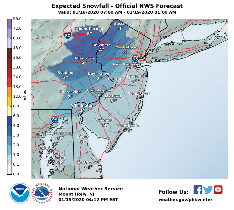
EPS is not a benchmark track. SLP heads from DC,to PHL to NYC. Tidbits image grossly misrepresents reality.
-
 2
2
-
 4
4
-
 1
1
-
-
43 minutes ago, NYCweatherNOW said:
Eps is much better to a snowstorm. Low right off the coast off Maryland parked south of long island


EPS is a nothing burger. Takes the SLP into PHL. Coastal plan gets inundated with wind and high surf.
-
3
-
1
-
 1
1
-
-
State College/PSU special. About on par for this season.
-
 1
1
-
-
SN+ in Hunterdon County. Instantly sticking to all surfaces. Healthy dendritic growth.
-
4
-
-
-
57 minutes ago, qg_omega said:
Disagree, this isn’t a storm coming in from the south where we thump ahead of a warm front, it’s a SWFE cutter. Southerly winds get going early before the precip arrives. The BL will warm quickly for anyone East of the Hudson River, decent chance it starts off as rain and may only go to White rain before we lose the dew point depression on the warm advection
Adamantly disagree with your limited assessment.
-
4 minutes ago, HVSnowLover said:
Yea where I am I might be able to hang on to 33-35 Snow for a little while, once it's above 35 it's complete white rain or just rain. Either way looks like a NW of I287 storm again only this time at least for those areas it will be snow instead of ice
Synoptics. Get a handle on it already. This is NOT a 287 event. Everyone snows heavily for 2-4 hours with 1-1.5 in per hour rates. It turns to some rain. Everyone on the board accumulates.
-
3
-
-
3 minutes ago, PB-99 said:
Doesn`t this originating out of the 4 corners and focusing it`s snow via WAA put it in that category ?
I just don`t see a secondary, so I thought the flow through the OHV puts it in that category
SWFE are classically overrunning events with precipitation developing over the gradient/baroclinic zone. Very different than a warm front running squarely into a CAD signature.
-
3
-
-
2 hours ago, Allsnow said:
We can’t have it that amped out in the Midwest. One thing to look for is how Chicago makes out. If they remain all snow it’s better for us.
Absolutely incorrect. Completely different setups. Coastal snow will breakout with isentropic lift from advancing warm front running into a very decent CAD signature. Chicago is none of that.
22 minutes ago, jm1220 said:This isn’t going to be all snow. This is a fairly typical SWFE that will change over but hopefully with a strong enough high to make the front end be snow.
This isn't a SWFE or gradient type system.
-
2
-
-
1 minute ago, Snow88 said:
It does eventually change to rain on every model
Synoptics please. Likely I said yesterday, textbook thump 2-5 area wide, then sleet, quickly to rain.
-
2
-
-
Uptown Afd is a perfect example of professionals not utilizing synoptic experience and common sense. Friday evening is text book quick hitting 2-5 type event, no questions asked.
-
3
-
1
-
-
I think we can write off the next 2 weeks.
-
1
-
1
-
-
Non event for the board. Even ACY will have mixing issues.
-
1
-
-
1/4 inch of snow in Hunterdon County
-
1
-
-
This feels identical to 97-98. Early season threats Nov into early dec that never materialized, followed by a complete lack of winter until one minor March event.
-
2
-
2
-
1
-
-
1 hour ago, psv88 said:
We do have proof because its happening now. Each year is warmer than the last (essentially).
I will be direct. Why deny? What is the motivation? Is it simply because it is a cause supported by liberals? Is there something else? I really dont understand why people deny, unless they work for the fossil fuel industry.
We deny because 1. we've had warming like this before and 2. It's not manmade. There's no reason to change our lifestyles or act as if we'll change the outcome. People need to stop being hysterical.
-
2 hours ago, psv88 said:
Yea. Agreed, climate change is simply poor countries trying to shake down rich countries. It's incredible how poor countries have managed to employ tens of thousands of scientists and alter data in their favor to try and squeeze a few bucks out of the rich countries.
Unless...you are completely wrong and the chosen remedy is not a transfer of wealth. It is self-regulation by individual countries, closing coal power plants, etc. Just this week, a court in the netherlands (where my family is from) ordered the country to cut emissions, on the basis of human rights.
https://www.bbc.com/news/world-europe-50864569
No transfer of wealth there.
But, who needs facts when they have Tucker, am i right?
Blah blah blah. We've heard this tired story before. It's a hoax. Paris Agreement would have taken American dollars to foreign countries. Meanwhile, China and India profit, and don't cut their emissions? Cmon. Liberal millionaires purchasing real estate at water's edge? Cmon.
-
 1
1
-
-
In the past 5 years, we've become too reliant on algorithm based products. Fundamentally sound forecasting through use of experience and avoidance of fantasy, has gone out the window.
-
Real ice events begin with ST's in the 20s and DP's in the single digits. Non-event for majority of this board.
Hunterdon County. 32F. Light PL and ZR
-
2
-
-
15 minutes ago, binbisso said:
Looking over 2meter temperatures on today's 12z Global's so far it looks like we will be below freezing from about 21 Z Wednesday through 18z Sunday. This is not way out in Fantasyland either starting in about 4 days. that would be a pretty impressive cold for this time of year
Not impressive by any means. Below average. Yes.
-
Just now, Ericjcrash said:
Fantasy range storm is a southern slider on the 0z GFS. Mid range is a rainout.
210 hr is not fantasy by any stretch of the imagination. This is a real threat. Important panels begin as early as 168 hr out.
-
1
-
-
1 minute ago, Snow88 said:
Yep at least there is a storm signal
The changes between runs could not be more extreme. HP over Upper MW on 12z. HP moving off the EC on 18z.
-
1
-
-
Just now, Brasiluvsnow said:
Enigma where exactly is Hunterdon ? I am in New City
Western County of NJ.
-
1
-
-
Moderate snow. Everything snow covered with 1/2 inch, except roads. Hunterdon County
-
1
-


Wet snowstorm potential Jan 25-26, mainly high terrain northwest of NYC
in New York City Metro
Posted
IF we were to snow along I-95, we'd be relying entirely on rapid SLP intensification coupled with very heavy precip. Could be elevation driven. This reminds me of April Fools storm 1997.