Doramo
-
Posts
236 -
Joined
-
Last visited
Content Type
Profiles
Blogs
Forums
American Weather
Media Demo
Store
Gallery
Everything posted by Doramo
-
MO/KS/AR/OK 2019-2020 Winter Wonderland Discussion
Doramo replied to JoMo's topic in Central/Western States
Freezing rain and sleet here . Forecast sez some snow showers this afternoon . Nice break from what it has been recently . -
MO/KS/AR/OK 2019-2020 Winter Wonderland Discussion
Doramo replied to JoMo's topic in Central/Western States
nice ! -
MO/KS/AR/OK 2019-2020 Winter Wonderland Discussion
Doramo replied to JoMo's topic in Central/Western States
the southward trend gives a tiny bit of hope....which is much better than nutten . -
MO/KS/AR/OK 2019-2020 Winter Wonderland Discussion
Doramo replied to JoMo's topic in Central/Western States
Looking good -
MO/KS/AR/OK 2019-2020 Winter Wonderland Discussion
Doramo replied to JoMo's topic in Central/Western States
Had a mixed event at first yesterday but ended up with some nice flakes with a dusting of snow -
MO/KS/AR/OK 2019-2020 Winter Wonderland Discussion
Doramo replied to JoMo's topic in Central/Western States
Thanks jomo...I should of looked at the ttile first... It had been the same for so long I guess I tired of looking...anyway my bad . And yeah as you mentioned winter in the plains etc. How about that snow monsoon they received in the North-West . I would so love a 3 ft snow here it our area. Anyway here is to hoping that the snow drought is finally over this winter and that mama nature reimburses us for the lack -
MO/KS/AR/OK 2019-2020 Winter Wonderland Discussion
Doramo replied to JoMo's topic in Central/Western States
Does anyone have an idea when there will be a winter 2019 - 2020 thread or is everybody still bummed out about 3rd (edit-3 yrs in a row) winter snow disparity ? -
MO/KS/AR/OK 2019-2020 Winter Wonderland Discussion
Doramo replied to JoMo's topic in Central/Western States
I'm loving it -
MO/KS/AR/OK 2019-2020 Winter Wonderland Discussion
Doramo replied to JoMo's topic in Central/Western States
I'm doing great . Hot one for the last day of Sept. with 90 degrees out today -
MO/KS/AR/OK 2019-2020 Winter Wonderland Discussion
Doramo replied to JoMo's topic in Central/Western States
From what I have been seeing / reading about snowfall predictions is that we will receive an average snow total . Based on what I have found for here that would be 8" . I would think that If the average of the last four years is figured into it then it would be less . -
MO/KS/AR/OK 2019-2020 Winter Wonderland Discussion
Doramo replied to JoMo's topic in Central/Western States
43 days for south central/southwest Missouri is way off . Here in Ozark county / southern Mo., has not hat a Winter Storm Warning the last two yrs or so . -
MO/KS/AR/OK 2019-2020 Winter Wonderland Discussion
Doramo replied to JoMo's topic in Central/Western States
Well the temp here is 28 and I hope it holds to at or below the freezing mark . That and it would be nice to see the low go a little farther south ...don't like freezing mix slop as we have had enough of it already . -
MO/KS/AR/OK 2019-2020 Winter Wonderland Discussion
Doramo replied to JoMo's topic in Central/Western States
Light freezing rain occurring here so far -
MO/KS/AR/OK 2019-2020 Winter Wonderland Discussion
Doramo replied to JoMo's topic in Central/Western States
Got huge 2" of snow ...I am grateful that we got that much and wished that all members would have got some . -
MO/KS/AR/OK 2019-2020 Winter Wonderland Discussion
Doramo replied to JoMo's topic in Central/Western States
Had the same here earlier.. -
MO/KS/AR/OK 2019-2020 Winter Wonderland Discussion
Doramo replied to JoMo's topic in Central/Western States
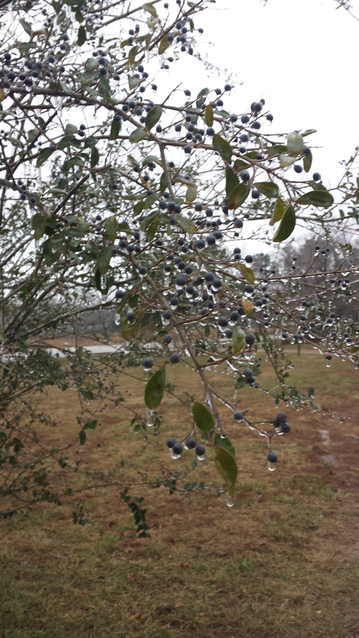
It has been 32 all day here with light freezing rain so far . The trees and bushes are glistening with ice and small ice cycles .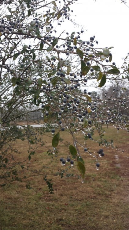
-
MO/KS/AR/OK 2019-2020 Winter Wonderland Discussion
Doramo replied to JoMo's topic in Central/Western States
When I see it ---- then I will believe it . -
MO/KS/AR/OK 2019-2020 Winter Wonderland Discussion
Doramo replied to JoMo's topic in Central/Western States
The models are pushing this farther south of which I hope it readjusts back toward the north . https://forecast.weather.gov/ DAYS TWO THROUGH SEVEN...Wednesday through Monday. Light snow may be possible Wednesday night into Thursday night. There remains uncertainty on the exact track of this system, so there are questions on how much of the area will be affected. At this time far southern Missouri will have the better potential for seeing any snow across the outlook area. -
MO/KS/AR/OK 2019-2020 Winter Wonderland Discussion
Doramo replied to JoMo's topic in Central/Western States
Huh? One would think with the forecast being only two days away things would come to a settled prediction but ? NWS Springfield,MO "Interesting forecast ahead as models continue their differing run to run solutions with the approach of the upper closed low tracking through the Southern Plains. Ah what a difference 12 hours makes. The 12z NAM offered continuity with the 00z ECMWF initially offering a boost in confident...then the 12z ECMWF came into line with the previously outlier GFS...which now leaves the NAM as the outlier which offered a solution that coupled the upper level jets associated with the approaching upper low and shortwave over the Great Lakes occurs. While the juxtaposition isn`t ideal...the ageostrophic flow enhances lift throughout the column particularly above 700 MB and enhances frontogenesis. Further the NAM shows a response in the low levels with a significant surge in the low level moisture advection as the system approaches the forecast area. This is all while sub freezing temperatures arrives with this system ...resulting in a concerning amount of freezing rain. Again while this would lead to a greater impact and still needs to be monitored...the evolving model solutions have largely come in line with the 00z GFS in tracking the system well southward... reducing accumulations of a wintry mix on Wednesday night/Thursday. However...this solution leads to wraparound lift on the back side of the system and the development of snow accumulations into Friday. I must suggest caution in this deterministic determination as later runs will be critical in determining the temperature profile of the lower atmosphere." -
MO/KS/AR/OK 2019-2020 Winter Wonderland Discussion
Doramo replied to JoMo's topic in Central/Western States
Not much being said at NWS Springfield for my area,, just this: A light wintry mix will fall from Wednesday night into Friday morning...with the precipitation changing over to rain for a period Thursday. At 80% chance for slop . Still have time for significant changes (for the better I Hope) -
MO/KS/AR/OK 2019-2020 Winter Wonderland Discussion
Doramo replied to JoMo's topic in Central/Western States
Yep! -
MO/KS/AR/OK 2019-2020 Winter Wonderland Discussion
Doramo replied to JoMo's topic in Central/Western States
The pattern is fixing to change for the better -
MO/KS/AR/OK 2019-2020 Winter Wonderland Discussion
Doramo replied to JoMo's topic in Central/Western States
Merry Christmas Y'all Maybe snow by the 30th (?????) is showing up on the local online forecasts . To me, just a mention of snow gives me hope and is much better than no mention at all like it has been lately . -
MO/KS/AR/OK 2019-2020 Winter Wonderland Discussion
Doramo replied to JoMo's topic in Central/Western States
It's the snow monster -
MO/KS/AR/OK 2019-2020 Winter Wonderland Discussion
Doramo replied to JoMo's topic in Central/Western States
thanks