Doramo
-
Posts
236 -
Joined
-
Last visited
Content Type
Profiles
Blogs
Forums
American Weather
Media Demo
Store
Gallery
Everything posted by Doramo
-
I hadn't noticed the earthquake here .
-
Although there is little chance of a huge snow event happening next week , just the mention stirred up my snow excitement
-
This is my go-to place for winter weather info!
-
Central/Western Medium-Long Range Discussion
Doramo replied to andyhb's topic in Central/Western States
The two E5's made the whole season in itself . I don't think we need another of those . Just give a bunch of E2-3's -
Light snow beginning to come down . The snow showing on the radar isn't much . Will get a dusting at most . As always it is fun to watch .
-
NWS forecast tonight: " A slight chance of snow before midnight, then occasional light snow after midnight. Low around 10. Light and variable wind becoming north 5 to 7 mph in the evening. Chance of precipitation is 80%. Little or no snow accumulation expected." This is a bonus snow I guess . I Like! I think I will stay up late to watch .
-
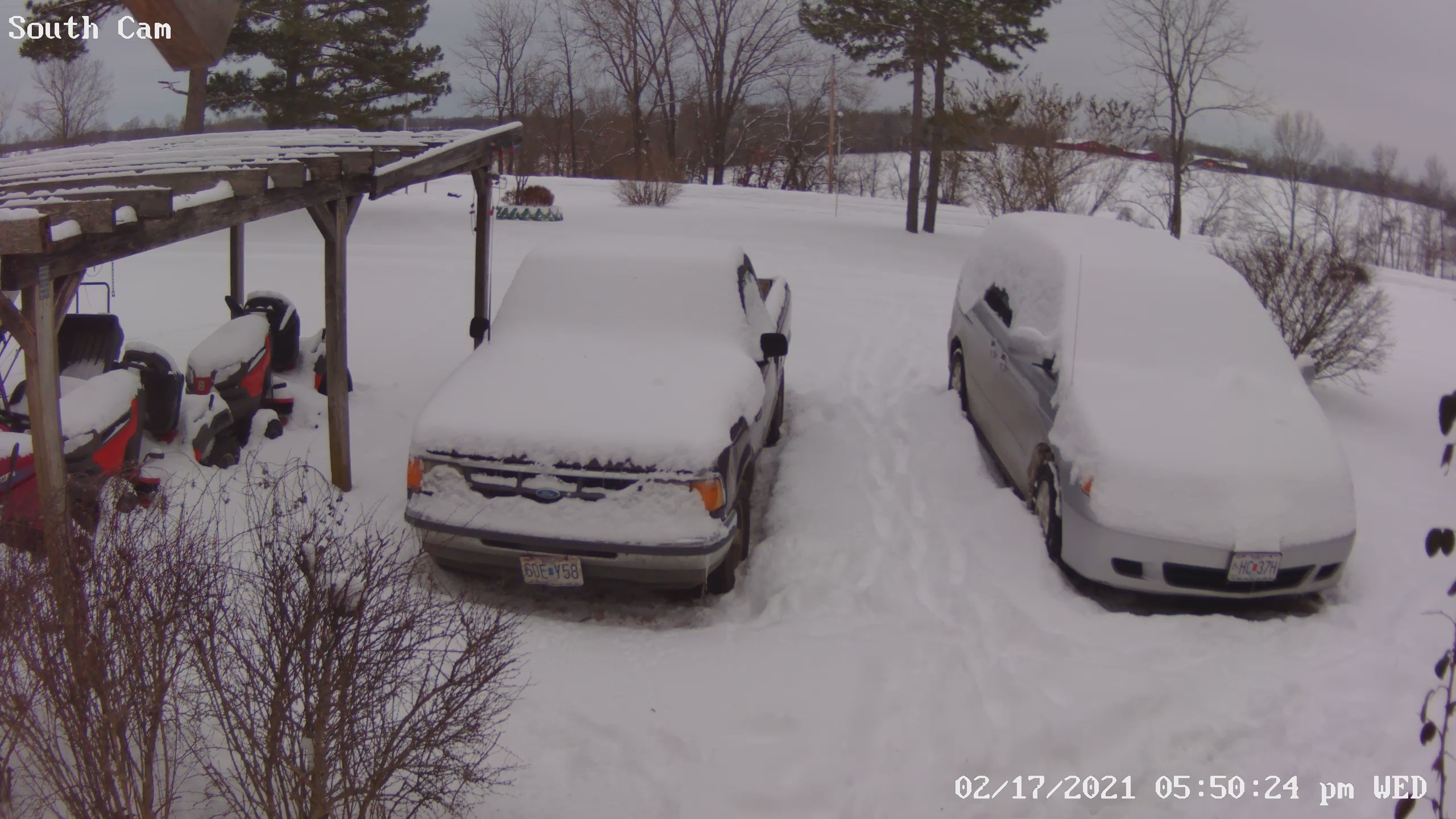
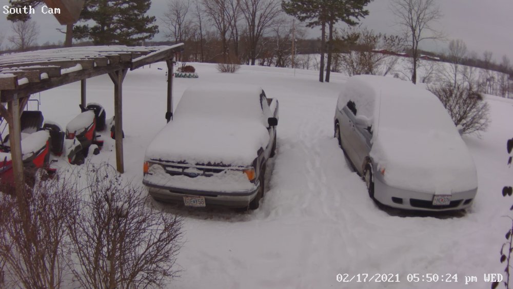
3" new snow here and happy as ever! No snow drought here ...
-
Low of -10.3 my Davis station . Drain lines are froze and my water line to the toilet is froze as well . ouch!
-
-3 here and partly cloudy . NWS calling for -8
-
At least 5" or 6" Hard to tell because of drifts and all . We have one area where the it was 1/2" where the wind funneled between two buildings. Some drifts are near 2 ft deep . The flat area that I measured snow depth before was affected by the wind . So I measured it in a wind protected area that was away from drifts and got the 5" in one spot and 6" in another . So maybe call it 5.5" ???
-
The last time I experienced this kind of cold was 1989 . I think the temp was 14 below zero . But that was in a January Edit ( December ). The record cold for West Plains, MO for February is 7 below . We might break that tonight .
-
My cold water line to my bathroom froze , I sure hope the line didn't burst. Yikes
-
It has finally slowed down to flurries but wow what an snow event .
-
Snowing moderate when I thought it would be over....I ain't complaining mind you . I will get a final measurement tomorrow , as it is too dark now. Besides it is 2 degrees outside
-
I measured 6" on the flattest non drift area I could find . Still snowing lightly . Temp at 3 degrees .
-
This must be the Grand Finally" as big flakes coming down now . Couple more hours like this and we will reach 6" easily . NWS adjusted tonight's low temp from -1 to -5 below . I'm thinking it will be more like -10 myself . Record lows tonight anybody?
-
Current Temp per my Davis weather station is a toasty 1 degree . It was -1 this morning . I think the NWS's Springfield forecast high of 7 degrees isn't going to happen. So how low could it get tonight?
-
We have close to 5" of snow and we may end up with 6" as lit looks like the last bit coming up from Arkansas is moderate in appearance to the radar . I am one happy snow loving nut
-
Maybe there is hope after all .Yes! A Winter Storm Warning for our area....This is the first WSW in several years . WINTER STORM WARNING Issue Date:6:09 PM Sun, Feb 14, 2021 Expiration:6:00 PM Mon, Feb 15, 2021 ...Dangerously Cloud (cold) Conditions and Accumulating Snow Will Continue through Monday... ...WINTER STORM WARNING IN EFFECT UNTIL 6 PM CST MONDAY... ...WIND CHILL WARNING REMAINS IN EFFECT UNTIL 9 AM CST TUESDAY... * WHAT...Dangerously cold wind chills will occur with values as low as 25 below zero. Heavy snow will occur with additional snow accumulations of 3 to 6 inches on top of what has already occurred. This will bring total snow amounts to 5 to 7 inches with locally higher amounts possible. * WHERE...Portions of southeast Kansas and central, east central, south central, southwest and west central Missouri. * WHEN...For the Wind Chill Warning, until 9 AM CST Tuesday. For the Winter Storm Warning, until 6 PM CST Monday.
-
Not to much snow here...close to one inch . Looks like we struck out on the best chance for a good un .
-
Thanks.....
-
Have a question about Mountain Home, Arkansas calling expected snow accumulation of 3-5 inches a Winter Storm Warning vs Dora, Missouri calling snow accumulation of 4-6 inches a Winter Weather advisory ? A higher accumulation expected in Dora , Mo obviously but it isn't called a Winter Storm Warning. Hmmmmm? Does Arkansas and Missouri have to meet different criteria ? Winter Weather Advisory URGENT - WINTER WEATHER MESSAGE National Weather Service Springfield MO 303 PM CST Sat Feb 13 2021 ...Dangerous Cold Through Monday Night... ...Good Chance For Accumulating Snow Starting Sunday and Continuing At Times Into Monday... * WHAT...Wind chill values will frequently be below zero through Monday night. Some areas will see wind chills as low as 15 to 25 degrees below zero. Snow with general amounts of 4 to 6 inches Sunday through Monday. Winter Storm Warning URGENT - WINTER WEATHER MESSAGE National Weather Service Little Rock AR 315 PM CST Sat Feb 13 2021 * AMOUNTS: Heavy snow is expected Sunday through much of Monday...with snowfall amounts of 3 to 5 inches expected. Locally higher amounts are possible...especially in the higher terrain.
-
Currently light snow coming down supposed to be dreezing frizzle
-
2:45 pm and the temp is 24 ...one would think that tomorrows above freezing temp isn't gonna happen also thus more ice can be expected .
-
Nice snow yesterday...about 2" here and places east of us got nearly 3" of the white stuff . So far this is the most total snow we've had in 6 years...a whole 3.5"...pitiful but I'll take it . We have 6 more weeks to go and am hoping that Feb will be a snow block buster . cheers!