

garfan
-
Posts
43 -
Joined
-
Last visited
About garfan

- Birthday 09/11/1967
Recent Profile Visitors
934 profile views


-
Would the snow ratios be lower with the winter storm moving in on Tuesday?
-
I have learned over time trusting model data accumulation amounts before the storm system comes ashore is pretty much futile.
-
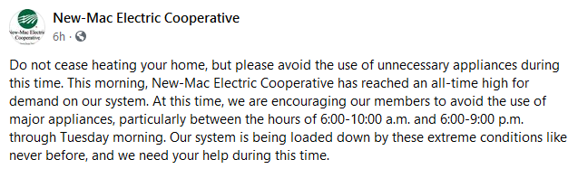
I know many of the electric companies are experiencing a high demand for electric due to the cold spell. Here is one example from the electric coop in SW MO that serves Newton County, McDonald County, and southern portions of Jasper County.
-
I know many of the the people I talk to just want to know how much snow they are going to get than what type of advisory or warning is in effect.
-
I see the 12Z Euro does not show much of a second storm due in about Wednesday.
-
MO/KS/AR/OK 2019-2020 Winter Wonderland Discussion
garfan replied to JoMo's topic in Central/Western States
The NAM and Canadian have backed off. Let's see what tomorrow brings. -
MO/KS/AR/OK 2019-2020 Winter Wonderland Discussion
garfan replied to JoMo's topic in Central/Western States
I expect the usual to happen. As soon as the storm system comes ashore and get sampled, models will start to shift even further north with the storm system as they usually do. -
MO/KS/AR/OK 2019-2020 Winter Wonderland Discussion
garfan replied to JoMo's topic in Central/Western States
Rooting for the EURO. Funny how the 12Z GFS has the majority of snowfall south of I-44. And that's not saying much. -
MO/KS/AR/OK 2019-2020 Winter Wonderland Discussion
garfan replied to JoMo's topic in Central/Western States
The Joplin metro is really struggling this winter in seeing more than just a dusting of snow. Seems when the temperature pattern is colder than normal, storm systems moving through the area lack moisture, or completely avoid the area. On the flip side, it seems when it's warmer than normal, there is usually plenty of moisture to work with (if we get a storm system) providing showers and even thunderstorms. We actually have a wetter than normal January in progress. -
MO/KS/AR/OK 2019-2020 Winter Wonderland Discussion
garfan replied to JoMo's topic in Central/Western States
Anyone else remember December 2018 when TV meteorologist in Oklahoma were predicting snowmageddon based on early model runs before sampling took place? It ended up being a major snow forecast bust. Anyway, this possible event early next week makes my mind go back to that previous time. Now no one has been forecasting any big snow amounts, except maybe Mike in OKC. I so much want a good snow! I have been watching the GFS/EURO daily, and it looks as if my area may end up with a cold rain to start, followed by a wintry mix, and then the dry slot; freezing drizzle. Hope things change between now and the event. -
MO/KS/AR/OK 2019-2020 Winter Wonderland Discussion
garfan replied to JoMo's topic in Central/Western States
I'll have what the 12Z EURO 168 hour forecast is having for SE KS and SW MO. -
MO/KS/AR/OK 2019-2020 Winter Wonderland Discussion
garfan replied to JoMo's topic in Central/Western States
I see the 12Z Euro has moved the higher frozen precipitation amounts mainly along and north of Highway 54 in Missouri. -
MO/KS/AR/OK 2019-2020 Winter Wonderland Discussion
garfan replied to JoMo's topic in Central/Western States
Do you ever mention severe weather in this thread when it's occurring during winter? -
MO/KS/AR/OK 2019-2020 Winter Wonderland Discussion
garfan replied to JoMo's topic in Central/Western States
A zoomed in look at NOAA's latest snow cover depth map. Notice the I-44 corridor is bare.
-
MO/KS/AR/OK 2019-2020 Winter Wonderland Discussion
garfan replied to JoMo's topic in Central/Western States
Too bad the 12Z ECMWF has really backed off on potential snow amounts for southern Missouri and northern Arkansas.

