Ravens94
-
Posts
1,832 -
Joined
-
Last visited
Content Type
Profiles
Blogs
Forums
American Weather
Media Demo
Store
Gallery
Everything posted by Ravens94
-
The “I bring the mojo” Jan 30-Feb 1 potential winter storm
Ravens94 replied to lilj4425's topic in Southeastern States
-
The “I bring the mojo” Jan 30-Feb 1 potential winter storm
Ravens94 replied to lilj4425's topic in Southeastern States
Just a coastal crusher on the icon. -
The “I bring the mojo” Jan 30-Feb 1 potential winter storm
Ravens94 replied to lilj4425's topic in Southeastern States
Icon is a hammer -
The “I bring the mojo” Jan 30-Feb 1 potential winter storm
Ravens94 replied to lilj4425's topic in Southeastern States
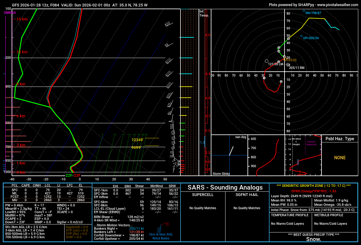
I mean this is rippage based on soundings. -
The “I bring the mojo” Jan 30-Feb 1 potential winter storm
Ravens94 replied to lilj4425's topic in Southeastern States
I wouldn't use the nam for precip at all at this range. It's going to move every run -
The “I bring the mojo” Jan 30-Feb 1 potential winter storm
Ravens94 replied to lilj4425's topic in Southeastern States
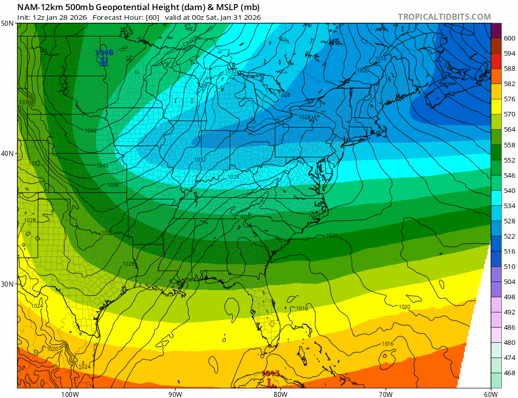
Baby steps Nam wants to still strengthen the storms in the Atlantic over the actual low off the coast. -
The “I bring the mojo” Jan 30-Feb 1 potential winter storm
Ravens94 replied to lilj4425's topic in Southeastern States
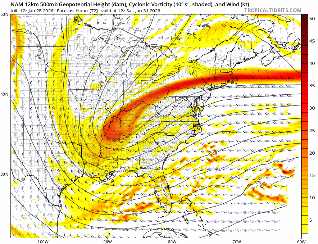
Tons of feedback on the Nam but closed 500 is huge. -
The “I bring the mojo” Jan 30-Feb 1 potential winter storm
Ravens94 replied to lilj4425's topic in Southeastern States
Wellllll Surface definitely has some CF but 500 is better -
The “I bring the mojo” Jan 30-Feb 1 potential winter storm
Ravens94 replied to lilj4425's topic in Southeastern States
Nam has lost the phantom energy off FL this run finally. Signs of early coastal development now. -
The “I bring the mojo” Jan 30-Feb 1 potential winter storm
Ravens94 replied to lilj4425's topic in Southeastern States
The far east tracks are messing with the mean on the gefs -
The “I bring the mojo” Jan 30-Feb 1 potential winter storm
Ravens94 replied to lilj4425's topic in Southeastern States
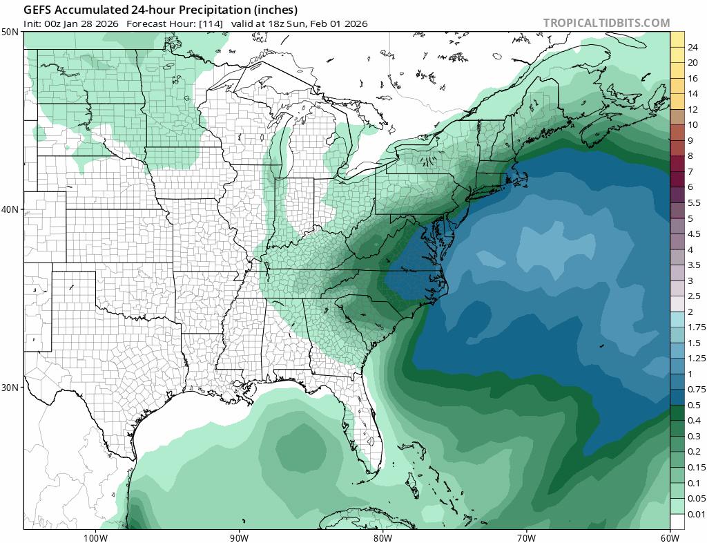
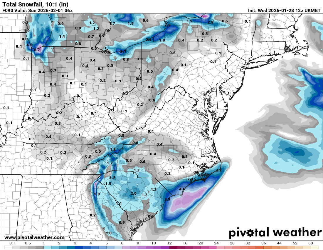
Foot+ in ENC. Pretty much all guidance is a snowstorm in this area. Probably the highest confidence area. -
The “I bring the mojo” Jan 30-Feb 1 potential winter storm
Ravens94 replied to lilj4425's topic in Southeastern States
Nam will be fine for coastal NC/SC but there's a trend on the NAM pushing more confluence -
The “I bring the mojo” Jan 30-Feb 1 potential winter storm
Ravens94 replied to lilj4425's topic in Southeastern States
The continued push of confluence in the NE is lowering heights the last 3 runs. NAM is moving energy in the atlantic alot the last 3 runs.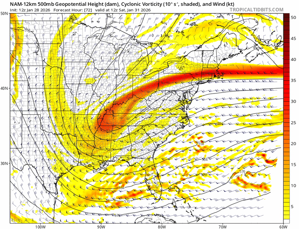
-
The “I bring the mojo” Jan 30-Feb 1 potential winter storm
Ravens94 replied to lilj4425's topic in Southeastern States
The push is continuing in the NE. Slightly lower heights.
-
The “I bring the mojo” Jan 30-Feb 1 potential winter storm
Ravens94 replied to lilj4425's topic in Southeastern States
I deleted it once its saw the timestamp. -
The “I bring the mojo” Jan 30-Feb 1 potential winter storm
Ravens94 replied to lilj4425's topic in Southeastern States
Need to make a coastal NC thread -
The “I bring the mojo” Jan 30-Feb 1 potential winter storm
Ravens94 replied to lilj4425's topic in Southeastern States
I agree Central to Eastern. Eastern atm is going to get crushed when the coastal cranks up. This may turn into a area wide monster if it bombs off Charleston. -
The “I bring the mojo” Jan 30-Feb 1 potential winter storm
Ravens94 replied to lilj4425's topic in Southeastern States
Gefs finally shifting south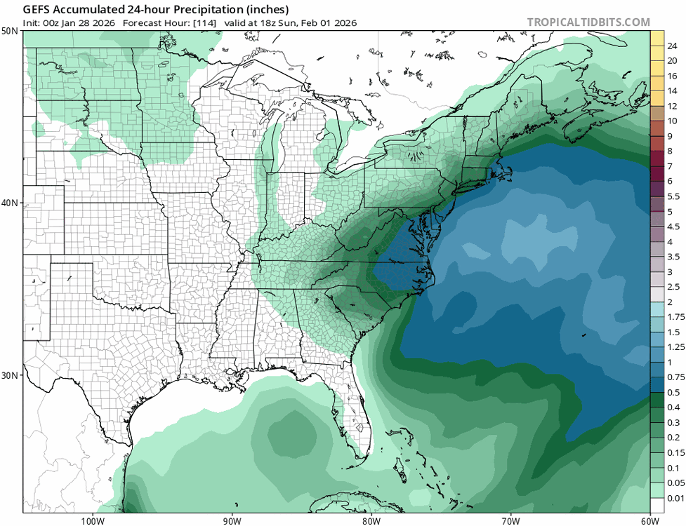
-
The Jan 31 Potential: Stormtracker Failure or 'Tracker Trouncing
Ravens94 replied to stormtracker's topic in Mid Atlantic
I can confirm i moved from MD to Sunset beach NC last year was a mess they have 0 snow removal equipment and you outta see how they brine. This place will be a disaster for days lol. No salt no nothing. 4x4 isn't a big thing here either luckily I'll never own anything not 4x4 lol. -
The “I bring the mojo” Jan 30-Feb 1 potential winter storm
Ravens94 replied to lilj4425's topic in Southeastern States
UK is catching on but for now coastal snowstorm 6z had nothing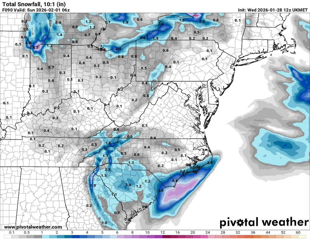
-
The “I bring the mojo” Jan 30-Feb 1 potential winter storm
Ravens94 replied to lilj4425's topic in Southeastern States
I'd like to see the euro come in with a bomb today. But looking at the upper levels fgen is off the charts and the 500mb pass on both the GFS and CMC is just textbook. Some good ratios believe it or not.
-
The “I bring the mojo” Jan 30-Feb 1 potential winter storm
Ravens94 replied to lilj4425's topic in Southeastern States
There's going to be some incredibly heavy bands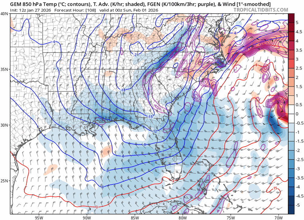
-
The “I bring the mojo” Jan 30-Feb 1 potential winter storm
Ravens94 replied to lilj4425's topic in Southeastern States
CMC wobbling south too. Low is starting to bomb off MB/ILM too. Starting to get excited CMC does have some obvious CF but the trend is there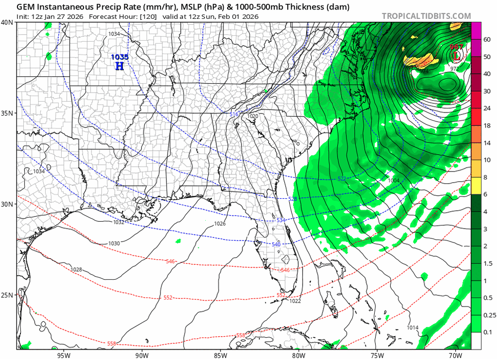
-
The “I bring the mojo” Jan 30-Feb 1 potential winter storm
Ravens94 replied to lilj4425's topic in Southeastern States
CMC big hit -
The Jan 31 Potential: Stormtracker Failure or 'Tracker Trouncing
Ravens94 replied to stormtracker's topic in Mid Atlantic
1980. https://www.weather.gov/mhx/Mar011980EventReview#:~:text=On the afternoon and evening,eastern part of the state.