

vwgrrc
-
Posts
397 -
Joined
-
Last visited
Content Type
Profiles
Blogs
Forums
American Weather
Media Demo
Store
Gallery
Posts posted by vwgrrc
-
-
Close to 1/2 inch on the ground, Plano/The Colony area. The real show will be this afternoon looks like

-
 2
2
-
-
47 minutes ago, TexMexWx said:
Looking way ahead, end of 00z NAM just gave us all sleet/freezing rain for midweek storm, ugh.
I'm not buying the second storm system somehow being bigger than this one for us in north Texas.
That 84hr image looks like a disaster for DFW. Reminds me the Dec'13 cobblestone ice storm. Massive power outage if that verifies! What worries me even more is GFS is basically showing a same picture with CMC not too far off

-
 1
1
-
-
1 minute ago, Ed, snow and hurricane fan said:
Ratios will be worse, but QPF better per GFS on mid-week system. Temps at the saturated level by Wednesday evening may not support efficient dendrite formation, could cause 'snizzle. 5 days out, but potentially even more interesting than Sunday, even if Sunday has better ratios just because of temps.
This is probably why Steve keeps calling the mid-week system more significant on his FB page today. He normally doesn't use any strong word for thing this far out...
-
1
-
-
4 hours ago, aggiegeog said:
GEFS is absolutely nuts. If correct it would shatter snowfall records for North and Northeast Texas.
0z is slightly less crazy. but still a lot!
-
1
-
-
12 minutes ago, cheese007 said:
Good chance FWD has egg on its face come Monday afternoon
I doubt they would miss it that badly at this rage. Meanwhile, 18z ICON and NAM remain bullish for DFW
-
16 minutes ago, aggiegeog said:
I wonder if the colder than modeled temps we are seeing daily will adjust the storm track south.
Thanks goodness someone distracted us from "the hold"

-
38 minutes ago, aggiegeog said:
Models seem to be showing a QPF hole over DFW as the energy transfers into a Gulf low early Monday. Midweek system looks to track further west which should fill in the snow hole.
Would you mind sharing which model(s) are you seeing this happening? I remember both GFS and NAM 12z remain fairly strong for DFW region
Edit: i guess i see what you mean. RGEM is showing the snow ends for DFW late Sunday instead of Monday morning then it's previously depicting? I feel that remain to be verified by other models. At the end of the day, 2+ inches for DFW is really really good given how things went in the past 5 years!
-
20 minutes ago, SWineman said:
I'm in downtown Fort Worth right now and am seeing some flakes drift down.
Temps at my house are at 22. Unless the sun break through the clouds, I see no chance of seeing temps hitting the forecasted 29 today.
Same here in SE Denton Ct. Forecasted to be a high of 2C and we're still sitting at -5C now. No way we can reach that high. This has been the case for the last several days. I wonder how this cold was so underestimated...
-
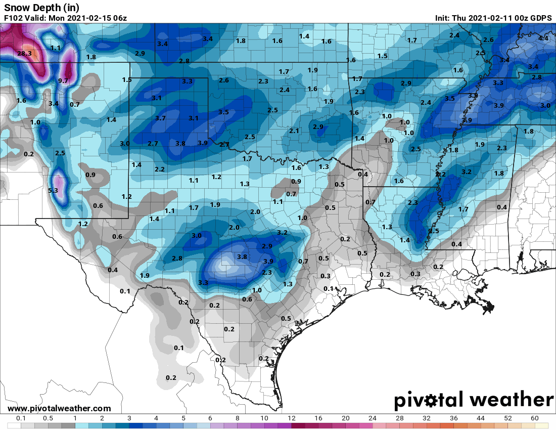
Have a feeling 0z batch going to be a somewhat encouraging cycle for North TX. ICON is bringing back more snow with a longer period. Short term models are depicting the new development AFD was talking about this afternoon. NAM is actually showing 2+ inches for DFW even before Sunday, which sounds a little crazy to me
Friday Night through Saturday...

An active weather pattern will be in place as we begin the
weekend across North and Central Texas. An approaching upper level
shortwave will be making its way through the region, tracking
from West Texas down toward the Hill Country. Given the shallow
cold airmass, this shortwave will induce strong isentropic ascent,
leading to the development of drizzle early Saturday morning.
With surface temperatures well below freezing, any drizzle will
instantly freeze upon contact, creating a thin coating of ice on
ANY surface. In additional the the drizzle potential, guidance is
beginning to trend toward a localized threat for a batch of sleet
or snow mainly west of I-35 Saturday afternoon. Given this is a
fairly new development, we`ll continue to watch this potential as
it could cause additional travel hazards as we go into Saturday
night.
-
I wonder if DFW would have any trouble with power outage this time? It was very bad in Dec 2013 ice storm, but not too surprised given that was almost pure freezing rain. This time is all snow, which shouldn't be an issue for most power lines. Any thought?
-
Looks like 18z ICON is bringing back a little bit more snow for DFW area while NAM32 is saying What snow?

Need GFS to pick a side...
-
12z GFS keeps the amount on the lesser side for DFW. I can only hope it doesn't pull back more at this point

-
DFW snow shield is no joke

-
Just now, aggiegeog said:
Yea a big change. I will wait to see if it's a blip or a trend.
I feel at least the timing (getting earlier) is a trend from the previous 4 runs unfortunately!
-
both 0z GFS and ICON are showing the Monday system to come & end quite a bit earlier than previous 4 runs. Now make that almost a Sunday event. Total snow amount also pulls back. This worries me a little
-
1 hour ago, cheese007 said:
And since 2015, the drier solutions have ended up closer to reality
This
-
17 minutes ago, aggiegeog said:
This is preceded by a major icing event in North Texas tonight
I personally don't see this actually. I mean my standard of major ice event would be Dec 2013. I'm not seeing that happen tonight at least for DFW. Thought?
-
53 minutes ago, aggiegeog said:
Now the ICON is showing the big snows followed by some of the coldest temps in Texas history. All of this on top of the icing issues over the next few days.
0z GFS and CMC are also showing a big snow day on the 15th. I wonder how the metro could screw this on up given it's still 5 days out
")
-
1
-
 1
1
-
-
6 minutes ago, SWineman said:
It’s 29 here in NW Tarrant and completely dry. I can’t see us getting to 45 today.
Same here in S Denton. I feel the model might underestimated the cold a little bit. I won't be too surprised if we end up with snow/ice Thursday morning.
-
4 minutes ago, DFWWeather said:
12z GFS is one for the record books at DFW. Three days in a row of temps around 0 (-1°F for two morning and 1°F one morning) with a high of 7°F on Sunday (that would be the coldest MAX ever by a wide margin). I don't think I have ever seen that on this model. Likely not going to be this extreme...but wow!
True~ but I'm actually more interested in the frozen precip it shows Sun/Mon timeframe at this point
")
-
8 minutes ago, SWineman said:
Yeah but will that be fast enough. Unless that snow back fills, the end of the snow is approaching a bit faster than forecast.
not an expert. but im seeing the back end of the snow still far into central tx?
-
15 minutes ago, cheese007 said:
Might bust in two separate directions given the lack of accumulations in northern Dallas
EDIT: Seems to be making a transition back to rain. Oh well was fun while it lasted!
interesting. i should be really close to you. still heavy snow.
-
it snows all the way north into OK. Seems like a model bust, in a good way
-
SE Denton close to Collin county snowing heavily. Starting to see accumulation on roof
Texas Winter 2021
in Central/Western States
Posted
The Wednesday storm will probably give NTX some real power issue looks like