

vwgrrc
-
Posts
420 -
Joined
-
Last visited
Content Type
Profiles
Blogs
Forums
American Weather
Media Demo
Store
Gallery
Posts posted by vwgrrc
-
-
54 minutes ago, Ed, snow and hurricane fan said:
5.6C at Love field at 17Z, 12 km NAM predicting 6.9C at 18Z. And the area is cooling down, not warming up. GFS forecast 18Z temp is 7.5C.
SPS reporting snow and 30F (may be auto observation), NAM sounding is sleet at 18Z, SPC Meso analysis off RAP says 850 mb freezing line is about there.

Correct me if I was wrong - what you're trying to say here is it's colder than models forecasted? I think that means less time for FR to fall but more snow?
-
26 minutes ago, TexMexWx said:
I got lucky last year to not lose power (I still don't know how exactly the grids work - I know I'm near a fire station but some people I know in a similar situation still lost power). I've been following this thread and consider me quite worried as well.
Well. there's a key difference right? Last year was a controlled power outage because of supply shortage. This time looks like powerline may not be able to holdup with the ice in some area. that's a bigger issue if it does happen because no one controls that and it takes longer to fix.
Edit: 12z GFS even more QPF for Collin County. This trend is bad.
-
 1
1
-
-
16 minutes ago, Powerball said:
It seems the Hi-Res models are struggling with how the handle the effect (if any) of DFW's UHI on surface temps. They could be onto something, but we'll have to find out.
That 12km NAM run is catastrophic. That would have to be amongst the worst ice storms in Dallas' history.
Regardless, there's pretty much a consensus across the models that Collin County will get a tons ice unfortunately. That's really concerning given how populated Allen/McKinney/Frisco area is. Most of our friends are in these 3 cities and got hit hard in last year's poweroutage.
-
12z 12km nam fr is simply insane for dfw especially the eastern half. But meanwhile 3km nam is showing basically nothing for Dallas..
Sent from my SM-G991U1 using Tapatalk -
Afd actually increased their ice forecast in the latest update.There are growing hints that this could be a snow event for DFW though I would still lean towards a primarily sleet event.
Sent from my SM-G991U1 using Tapatalk
-
41 minutes ago, cheese007 said:
FWD mentioned in the short term that they nudged down ice totals and explained their reasoning there
Yes. Sounds like their reasoning for that is the latest NAM suggesting a slower cold air front so that there's a smaller time window for FR to fall in DFW. But my impression for this type of event is the models normally underestimate the progression of cold air thus the surface temp will look warmer than what actually pans out. Maybe that is only the case for GFS not NAM?
-
15 minutes ago, cheese007 said:
It begins...

URGENT - WINTER WEATHER MESSAGE
National Weather Service Fort Worth TX
858 PM CST Tue Feb 1 2022

TXZ091-092-100>102-115>117-129-021200-
/O.UPG.KFWD.WS.A.0001.220203T0000Z-220204T0000Z/
/O.NEW.KFWD.WS.W.0001.220202T2100Z-220204T0000Z/
Montague-Cooke-Young-Jack-Wise-Stephens-Palo Pinto-Parker-
Eastland-
Including the cities of Bowie, Nocona, Gainesville, Graham,
Olney, Jacksboro, Decatur, Bridgeport, Breckenridge,
Mineral Wells, Weatherford, Briar, Cisco, Eastland, Ranger,
and Gorman
858 PM CST Tue Feb 1 2022

...WINTER STORM WARNING IN EFFECT FROM 3 PM WEDNESDAY TO 6 PM CST
THURSDAY...

* WHAT...A transition from rain to freezing rain then to sleet and
  snow. Total snow and sleet accumulations of 2 to 4 inches and
  ice accumulations of around one tenth to two tenths of an inch.

* WHERE...Portions of north central Texas.

* WHEN...From 3 PM Wednesday to 6 PM CST Thursday.

* IMPACTS...Travel will be dangerous. The hazardous conditions
  will impact the morning and evening commute on Thursday. The
  cold wind chills as low as 5 below zero could result in
  hypothermia if precautions are not taken. Power outages and tree
  damage will be possible due to ice.


PRECAUTIONARY/PREPAREDNESS ACTIONS...

If you must travel, keep an extra flashlight, food, and water in
your vehicle in case of an emergency.

The latest road conditions for Texas can be found at
drivetexas.org.

&&

$$
URGENT - WINTER WEATHER MESSAGE
National Weather Service Fort Worth TX
858 PM CST Tue Feb 1 2022

TXZ093>095-103>107-118>121-130>134-141>145-156-157-021200-
/O.UPG.KFWD.WS.A.0001.220203T0000Z-220204T0000Z/
/O.NEW.KFWD.WS.W.0001.220203T0000Z-220204T0000Z/
Grayson-Fannin-Lamar-Denton-Collin-Hunt-Delta-Hopkins-Tarrant-
Dallas-Rockwall-Kaufman-Erath-Hood-Somervell-Johnson-Ellis-
Comanche-Mills-Hamilton-Bosque-Hill-Lampasas-Coryell-
Including the cities of Sherman, Denison, Bonham, Paris,
Carrollton, Denton, Lewisville, Flower Mound, Plano, McKinney,
Allen, Frisco, Greenville, Commerce, Cooper, Sulphur Springs,
Fort Worth, Arlington, Dallas, Rockwall, Heath, Terrell, Kaufman,
Forney, Stephenville, Dublin, Granbury, Oak Trail Shores,
Glen Rose, Cleburne, Burleson, Waxahachie, Ennis, Midlothian,
Comanche, De Leon, Goldthwaite, Hamilton, Hico, Clifton,
Meridian, Valley Mills, Hillsboro, Lampasas, Copperas Cove,
and Gatesville
858 PM CST Tue Feb 1 2022

...WINTER STORM WARNING IN EFFECT FROM 6 PM WEDNESDAY TO 6 PM CST
THURSDAY...

* WHAT...A transition from rain to freezing rain then to sleet and
  snow. Total snow accumulations of up to two inches and ice
  accumulations of two tenths to half an inch.

* WHERE...Portions of north central and northeast Texas.

* WHEN...From 6 PM Wednesday to 6 PM CST Thursday.

* IMPACTS...Travel will be dangerous. The hazardous conditions
  will impact the morning and evening commute on Thursday. The
  cold wind chills as low as zero could result in hypothermia if
  precautions are not taken. Power outages and tree damage are
  likely due to ice.


PRECAUTIONARY/PREPAREDNESS ACTIONS...

If you must travel, keep an extra flashlight, food, and water in
your vehicle in case of an emergency.

The latest road conditions for Texas can be found at
drivetexas.org.

&&

$$
Will have to say the ice accumulation in this warning seems a lot less than what most models are suggesting. Not sure if they see something that we don't
Meanwhile, 0z CMC is coming in. Even more FR and sleet than its previous runs. Crazy!
-
 1
1
-
-
Dumb question but what's NSSL?The NSSL is just plain ugly.
Widespread 0.75"+ of ice, and that's right from the start (no rain), and then a good 1"+ in QPF of sleet on top of it (sleet is typically assumed to have a 3:1 ratio, so that translates into 3" of sleet).
That would probably shut thing down until Saturday, when it finally melts.
Sent from my SM-G991U1 using Tapatalk
-
0z HRRR decreased the fr quite a bit but uped snow amount. This is good news! Will need to watch if NAM follows.
Sent from my SM-G991U1 using Tapatalk -
18z GFS mostly unchanged for DFW, about 1" of freezing rain on the eastern half and less on the west side. Crazy even Austin will be under some significant icing.
-
14 minutes ago, Powerball said:
True, but when you compare the 18z HRRR with the 12z HRRR run, there was a significant increase in ice amounts (widespread 0.50"+ amounts in the northern/eastern suburbs, and widespread 0.25"+ amounts elsewhere).
Same on 18z NAM as well. It's now only 33hr out but the QPF almost doubled. Is this even right??
It's also notable the FR band seems moving NW quite a bit compared to 12z. Does this mean it may put DFW out of the core area is very worth watching out for!
Edit: 18z NAM mostly consistent with 12z. I wonder if we need an Ice Storm Warning soon.
-
1
-
-
The good news is 18z HRRR just came in. It seems less scary than NAM at 12z. But I don't know how those 2 compared in this case.
-
11 minutes ago, Powerball said:
That is slightly less bad than the 06z run, fortunately.
True but unfortunately that stops with GFS. Both 12z NAM and Euro are suggesting more compared to yesterday. Very very concerning since I feel NAM is a stronger model at this range.
-
17 minutes ago, David-LI said:
12z GFS with very concerning freezing rain accumulations.

12z NAM is even more concerning with Collin and Denton at 1.3". The FR band is merely 200 miles wide but dramatically DFW is right in the middle ...
-
14 minutes ago, DFWWeather said:
The NAM incorporates the GFS with higher resolution built into it. I would go with the NAM over the GFS. It is very concerning that the NAM is going with that much freezing rain.
The 12z GFS is pretty bad with nearly 1/2 an inch of freezing rain. That is a lot of ice folks! It also is showing 1.5 to 2.0 inches of sleet on top of that for Dallas and Tarrant Counties.
True! I'm not in this profession but do watch wx closely. I don't think I've ever seen that much of FR for DFW. I experienced 2013 cobblestone (with 2-day power outage) but I didn't check the data prior to that. My guess is this could be as bad as that one if NAM holds true.
Sorry if this is a bit off-topic. But last year we were lucky didn't have any power issue in the February storm. However I think that was a controlled outage and we're probably on the same section with a large hospital. This time if it gets too icy, powerline comes down regardless and may take a lot longer to recover. I wonder how would y'all get prepared in this case (other than what NWS suggested ofc)? Especially those of you had power issue last year, what can be realistically done differently? Thanks!
-
1 hour ago, DFWWeather said:
***12z NAM forecasting almost 1.00 inch of freezing rain for the Metroplex.***
At least 12z and 6z GFS dialed that down a little bit from yesterday. About 10-20% using Collin Ct as a benchmark. Let's hope that's a trend. Otherwise, significant power outage is likely.
-
1 hour ago, DFWWeather said:
The 6z models this morning of freezing rain amounts are getting into Ice Storm Warning criteria. Definitely think the Watch will get upgraded to a Winter Storm Warning as early as this afternoon, but certainly by tomorrow morning if trends continue with some counties maybe upgraded to an Ice Storm Warning.
I am also growing concerned of severe cold Friday and Saturday morning into the Metroplex (ie. temps down to 10°F or lower), so we may be dealing with Hard Freeze Warnings also.
The main point is models are trending colder with the the 32°F line on average expected 3 hours earlier than yesterday, approximately 9PM ish for KDFW Wed evening.
***12z NAM forecasting almost 1.00 inch of freezing rain for the Metroplex.***
12z HRW actually has KDFW cross 32F right after 6PM. That's crazy. But I personally don't know too much about the background or track record on that model.
-
1
-
-
Like a hotel room? How you know they will have power if you don'tI did book a room though. I'm not getting caught without power like I did last time.
Sent from my SM-G991U1 using Tapatalk
-
holy moly ~ the FR QPF on both 12z GFS and NAM is simply mind-blowing and put DFW in the center of the mess. I wonder if anyone remember what was the forecast data leading upto the cobblestone 2013 storm. This has some real potential to surpass that!
-
1
-
-
18z NAM is like - oh sure I agree with y'all! (GFS, CMC, etc)

-
1 minute ago, DFWWeather said:
Not really, it is going for more sleet as opposed to freezing rain.
Yes that's what I mean. I think sleet is easier on trees and powerlines as it doesn't stick to surface like FR does, which is always the main concern for event like this in DFW.
I was in Richardson in December 2013. I remember the power went out not even too long after the FR begins. I can't open my car the next morning
-
42 minutes ago, DFWWeather said:
The 12z GFS is forecasting at DFW Airport 1.7 inches of sleet and 0.26 of an inch of freezing rain.
Good thing is CMC stepped down a little bit on QPF compared to yesterday. If GFS holds thru out tonight, I may need to start thinking abt what to prepare for a power outrage to be honest.
-
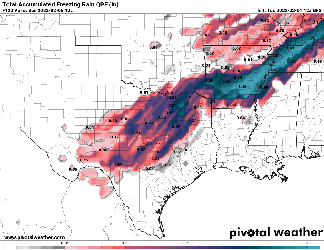
Someone tell me I'm reading this wrong please - 12z GFS seems even more bullish on the frozen QPF for most of the DFW. Almost X2 from 0z last night?! That's very concerning
-
1 minute ago, Powerball said:
The headlines (or lack thereof) really don't matter to me.
I hate ice (along with the extreme cold coming behind it) and I'm not looking forward to any amount of it.
I'm hopefully it does trend to a nothingburger.
100% agree. Like other had posted above - the takeaway at this point is that NAM is trending towards GFS, which is not a good new for the power grid.
Texas/Oklahoma Discussion & Obs Thread 2021
in Central/Western States
Posted
while 18z NAM is still painting DFW with FR really hard! I'm on FWD's side on this one