

vwgrrc
-
Posts
397 -
Joined
-
Last visited
Content Type
Profiles
Blogs
Forums
American Weather
Media Demo
Store
Gallery
Posts posted by vwgrrc
-
-
GFS seems having trouble handling the system late next week. Also great variation between models/ensembles. Don't remember when was the last time I saw this chao...
. -
29 minutes ago, aggiegeog said:
Despite what individual op runs show I am becoming very optimistic about the chances for winter precip anytime between Friday and early Jan, likely multiple rounds four areas north of I-20 and maybe a round south of there also. We have a solid -EPO and an active STJ both are set in place for at least the next couple weeks and likely longer.
You might be right. The latest GFS went crazy for N TX through Jan 3rd. It's just one run at this time, but could be indicating something.
-
46 minutes ago, JoMo said:
12z Euro had more of a neutral tilt as well. Maybe a light mix on the NW side of precip shield wherever that ends up. Mood snow on Christmas eve still possible for many.
Edit: And a massive winter storm on Day 9. Good grief.
Day 10 lol, just because it's funny.

This would be similar to the 0z GFS last night, which is gone from GFS today. So...
-
After several days of consistency, kind of hard to believe the 18z GFS back off the cold front and just give the metro plain rain...
-
2 minutes ago, aggiegeog said:
18Z GFS with a scary run. Widespread areas of Texas modeled to get over 3 inches of liquid in sub freezing air.
Yes. But still, 7 days to go. I wouldn't get too concern or excited about that until probably Monday to Tuesday. If the model tells the same by then, that's something serious!
-
16 minutes ago, aggiegeog said:
12Z Euro is wow and it transitions things to snow early enough for much of it to fall as white stuff though all types are likely. Pretty much over a half foot of varois precip types along I-20 across the state.
Which means no wintry precip for North TX, right?
-
42 minutes ago, aggiegeog said:
My issue is the models have been very consistent with this event. The ensembles have not wavered and the operational runs, especially the GFS, have been incredibly consistent. Personally I have never seen the models show this strong of a signal, this far in advance (the GFS has been on this for a week without wavering significantly). I will be watching the NAM intently starting on Tuesday as it is the best model for Arctic air masses.
Agree on the consistency (except for 0z last night). Confidence is getting higher for some wintry wx in NTX. But I think there's a trend of the freezing rain/sleet band shifting north with the latest 12z showing the Metro is right on the edge. I wouldn't be surprised to see the Metro "dodge" the event eventually.
-
The 18z gives DFW 30+ hours of freezing rain/sleet! I'll only believe it when I see it.
-
Looks like DFW gonna have an icy Christmas per the latest GFS run...
-
Here is a pic of the freezing rain off of pivotal.
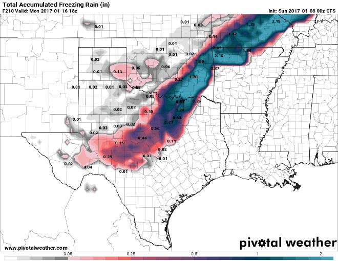
Oh mine... What exact time frame will that fall for the metropolex?
Sent from my iPhone using Tapatalk -
Well, that looks a bit too warm for now to get that happens for the metro.
With that being said, this might be the only time I do not wish it verifies because I will be flying back to DFW on Saturday night... But we're 6 days out. Things may change
-
23 minutes ago, jhamps10 said:
So, raise your hand if your commute home took more than an hour more than it should have.... *raises hands* seriously, we can't even handle a dusting of snow in ft worth.... Seesh...
Just got back from a 2 hour drive home, which normally takes 20 minutes...
-
I think we can almost call this a "bust". It is virtually blizzard condition here in Downtown Dallas.
-
Snow on road in Downtown Dallas. This is really a lot heavier than foretasted!
-
5 minutes ago, aggiegeog said:
GFS now coming back on board also. Not seeing any signs of a huge event, but there is a good shot for those north of I-20 to see 2-4". The cold is coming with storminess behind it, that is a very good snow signal though without a STJ connection it is doubtful that we see anything heavy.
Agree. 18z does look changing. But I wonder if this gonna be a good trend? Is still there enough time (4 dayish) for STJ to form for this area?
-
6 hours ago, aggiegeog said:
The late week winter storm appears to be coming back on the models as expected.
Probably not for TX. Looks like any precipitation should be very light at this time...
-
24 minutes ago, bubba hotep said:
What a train wreck on the 00z GFS

Well, unfortunately, this happens a lot during this time of the year. We should probably really not looking at what model says about precipitation outside 3 days. NWS AFD today also highlighted the uncertainty.
-
17 minutes ago, DFWWeather said:
Strongly agree...and in this case the colder drier solution looks correct imho. Given the amount of Arctic air that will be flowing down from the north, flow coming almost due north from the Arctic circle, the deeper, colder solution the ECMWF has looks correct. This is a McFarland setup. Folks, this is not a favorable upper air pattern for big DFW winter storm. The op GFS looks like an outlier to me and doesn't agree with the majority of its ensemble members. If anything, further south would be a target for frozen precipitation. I would not be surprised for freezing temps getting into LRGV with this setup.
The EPO going postive allowing for mid month warmup looks in error as the long wave global synoptic pattern says that should stay negative. AO, NAO, WPO, PNA, EPO (arguably) remaining negative points to widespread CONUS cold (save for Florida). Climate Prediction Center is in agreement as well with cold lasting well into week 2 of January. Joe Bastardi explains this today in his morning video. With Greenland blocking this cold is going to be in no hurry to leave with more building up behind it.
I thought the McFarland Signature was what contributes to the Dec 2013 dfw ice storm? But maybe I was wrong.
-
1 hour ago, bubba hotep said:
The 00z Euro package was pretty encouraging for us in DFW area. The op had some changes that I liked at H5 and it appears to be the dry outlier with both the EPS mean and control being wetter. About 30 of the EPS members showed some variation of winter weather in DFW.
Also, the Para GFS has been trending our way with 06z being the farthest north yet:

I'm liking the trends but still not sold.
Interesting. The 12z GFS seems a lot drier for dfw. I thought it's going to join Euro...
-
The last couple runs seem to be warmer for dfw metro, hope that's not a trend!
-
Just now, bubba hotep said:
Bitter cold and no snow for DFW, maybe something for far East Texas along I20. Orientation of the trough is different than 00z and that looks to keep much of Texas dry and cold. Still lots of time and the setup keeps changing each run in the longer run. Only steady feature is the -EPO and cold. Feb '11 was a Nina snow event driven by an EPO dump, so it can happen.
Well, if it's so different from the last run of Euro and GFS, I guess it's more likely to be a hiccup? I don't think Euro normally catch changes "earlier" than GFS.
-
6 minutes ago, jhamps10 said:
well bubba... do tell, please give us some insight
")
SE forum is talking about it. Sounds like too warm...
-
12z Euro says
busted? Please do tell
Sent from my iPhone using Tapatalk -
This is starting to peak my interest but still lots of unknowns, esp since mesoscale features play a big role in these setups.

I wonder if this only counts snow or includes ice. 12z shows dfw with a good amount of time under ice next Thursday. If that turns out to be what happened, this might be a replay of December 7 2013, probably worse with snow on top of ice.
Sent from my iPhone using Tapatalk
Texas/New Mexico/Louisiana/Mexico Obs And Discussion Thread Part 8
in Central/Western States
Posted
The latest AFD is also discussing it. But that looks very light with little impact at this point...