

vwgrrc
-
Posts
397 -
Joined
-
Last visited
Content Type
Profiles
Blogs
Forums
American Weather
Media Demo
Store
Gallery
Posts posted by vwgrrc
-
-
Some freezing rain seems likely for Monday AM in DFW metro. Still could change a lot at this point.
-
On 1/13/2024 at 11:13 PM, TXHawk88 said:
Not to get too ahead of ourselves but early next week has been looking interesting on GFS & Euro for a couple days. Finally the GFS & Canadian are showing winter precip, it has been showing cold rain with temps in the low 30’s. Not going to go too far off into the weeds because we are still 190~ hours out and a ton will change.
The pattern looks pretty favorable to what would normally give us our best shot at winter weather. We don’t have a crazy warm up before the next cold front comes through next Friday - Saturday
Just happy to have stuff to watch over the next 10 days. Good luck to everyone tomorrow.
Speaking of which, I don't think I ever seen such a huge divergence between GFS and CMC like this for the next Monday. I literally laughed out loud

-
2 hours ago, TXHawk88 said:
With every new model run I’m losing hope on seeing anything decent expect some freezing drizzle here in DFW. Every model is coming in drier and drier, terrible waste of some very cold temps. Realistically still have 6 weeks to get something exciting this winter.
Well. 12z Euro is not showing any drier and it's actually shifting the system a bit north toward Dallas. That said, there's still time for things like this to change drastically.
-
 1
1
-
-
13 minutes ago, aggiegeog said:
Models generally showing >0.1" for areas E of I-35 with amounts increasing as you go NE. Canadian is most aggressive with QPF over 1" for NE corner of state. NAM and ICON are driest with maxes around 0.25".
Euro and UKMET are keeping S half of state above freezing Monday morning. Canadian and ICON are most aggressive with the cold bring the freeze line closer to the coast Monday. GFS in between.
Most models have the 850mb front near I-20 Monday morning with the 850mb freeze line lagging just behind that front.
Pretty safe bet that north of I-30 most dominant precip type is snow. South of I-20 and south to the surface freeze line will be mainly freezing rain. Making the area from Waco to Marshall and up to Texarkana the battleground.
Amounts of each of the precip types in a particular location are tricky at best to forecast right now especially in the battleground area. The best bet I can make right now is the area from Paris to Texarkana will see 3-8" of snow as that is where temps and qpf are easier to nail down. South of there some will get upwards of 2" of sleet and some may get 0.25" of freezing rain but cannot nail down where those will be yet.12Z Euro seems shifting the battleground a bit north which can be a problem for Dfw if other model to follow. But i think all of them are trending a bit drier in the last 3 runs.
-
1 hour ago, aggiegeog said:
Models definitely are trending towards a bigger event for the NE quad of the state. Still not looking like a huge event but temps in low 20s will allow for efficient accumulations and if freezing rain the slow rates over a longer time period would allow for significant enough accretion to cause issues.
Canadian is basically calling a somewhat big event for Dallas and it's showing a trend from yesterday. Definitely worth watching if Euro will join and what Gfs says next run.
Edit - Euro joined the chat as well. Timing is slightly later than the other two. Not a terrible idea to start preparing early.
-
1
-
-
13 hours ago, vwgrrc said:
But the both 12z and 18z suit came in pretty dry for Dallas is it not? It's cold for sure but dry.
I might said that too soon. Both 12z Gfs and Cmc are showing some icing for DFW. Cmc is actually quite strong on that. I think it's a bit concerning at this range to see some model convergence especially if they trend.
-
1
-
-
1 hour ago, Ed, snow and hurricane fan said:
Euro 850 temps reach freezing around 12Z Monday, with three to four tenths falling. I'm going to be optimistic and say 4 inches of snow isn't out the question. That is good news, bad news is Houston drops to between 20 and 24F Tuesday morning with near 15 hours of sub-freezing weather. This results in my palm tree looking like it is dead for 4 or 5 months after. Would have been nice to not have a hard freeze two of the last three winters.
3 hours ago, canderson said:I think Dallas is in a decent spot to get a couple inches of snow actually next Monday. It’ll be icey but might be snow for a while before the inevitable changeover. Weatherford NW seems ideal for a legit snow.
But the both 12z and 18z suit came in pretty dry for Dallas is it not? It's cold for sure but dry.
-
2
-
-
23 minutes ago, Powerball said:
To some extent of course, the amount of daytime heating will be a question mark as well.
Stronger heating (thus greater surface instability) can make up for a somewhat underwhelming LLJ.
That said, the satellite is showing quite a bit of cloud cover this morning.
.
Pretty much full blast sun out in Collin Ct now
-
Not good when you have a W shift to cover 6M+ like this ...
-
2
-
 1
1
-
 1
1
-
-
7 minutes ago, Powerball said:
That has to be off, or it could be a measurement over one of the lakes (I.E. Grapevine or Lewisville), which always run warmer.
Official observations from NWS sites show everyone is still in the upper 20s as of 1pm.
True. But I wonder why there seems a lot of melting underway. I see the streets are clearing up and nothing really stick on trees or power lines here, which is really good. Maybe the actual accumulation could be less than expected
-
19 minutes ago, weatherextreme said:
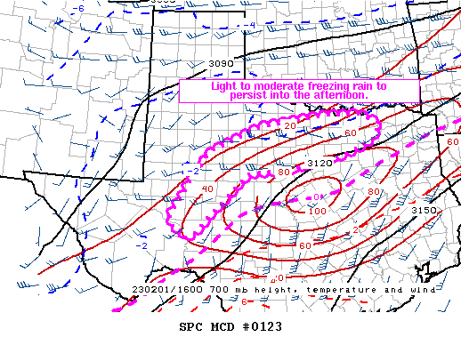
Mesoscale Discussion 0123
   NWS Storm Prediction Center Norman OK
   1135 AM CST Wed Feb 01 2023

   Areas affected...north-central Texas...northwest Texas...and
   portions of Southwest Texas

   Concerning...Freezing rain

   Valid 011735Z - 012130Z

   SUMMARY...Light to moderate freezing rain will persist into the
   afternoon from north-central Texas to near Abilene and east of
   Midland.

   DISCUSSION...A band of relatively concentrated precipitation has
   developed from west of San Angelo to northern Texas. This is forming
   in a zone of weak frontogenesis and warm air advection around 700mb.
   This will favor heavier precipitation rates in this corridor through
   the afternoon. The heaviest rates are expected by late afternoon as
   frontogenesis strengthens and focuses in this region. The last
   several HRRR runs suggest a mesoscale corridor of total QPF in
   excess of 0.75 inches. Observations this morning have shown a mix of
   sleet and freezing rain, but this is expected to transition to
   mostly freezing rain this afternoon as the cold air becomes more
   shallow. Icing is expected across most of this region with more
   significant icing possible where any banding can develop later this
   afternoon/evening.
When you see SPC mesoscale discussion while it's 26 outside... I hope my power holds tonight.
-
9 minutes ago, weatherextreme said:
Lots of reports that radar is showing freezing rain, but nothing hitting the ground. Do we know what's causing that and could it change ?
Denton CT falling pretty hard consistent with what radar shows.
-
Starting to feel there's a chance the outcome could be even worst than forecasted today. Most of the short range models tonight shows little to nothing for the state as of midnight. But in reality, West TX is already seeing FR or sleet at this point. Probably gonna be a real mess in DFW tomorrow.
-
51 minutes ago, DFWWeather said:
The Ice Storm Warning is truly a rare issuance in this region. This generally is not issued unless ice accretion totals are expected to be 1/2 inch or greater, which is severe icing. If forecast holds this, combined with this 1/2 inch sleet already on ground, is turning out to be the worst ice storm this century for the western part of the Metroplex. I doubt very seriously temperatures will move far enough above freezing to improve road conditions, especially in this area, until late Thursday or possibly into early Friday. This surpases the December 2013 and February 2003 events.
I'm actually a bit shocked they issued the warning at this point given the latest HRRR isn't that aggressive for tomorrow and the amount is *only* up to 0.25. IMO December 2013 was much worse.
-
54 minutes ago, olafminesaw said:
Holy cow.

can you elaborate pls?
-
1
-
-
29 minutes ago, SWineman said:
I've got thunder in Saginaw, half sleet/half raindrop pouring from the sky.
Edit: I'm concerned that the current mix might accrete faster than either of the p-types alone.
really started to get concerned for a power outage at this rate.
-
2 hours ago, SWineman said:
18z NAM 3K

0z NAM 3K shows even more ice for Dallas Ct. wth...!
-
1 hour ago, SWineman said:
18z NAM 3K
On the flip side, 0z HRRR seems lowered the amount of ice in Dfw by a lot. At least for tomorrow! I find it hard to understand why models are so struggling with this at close range.
-
1
-
-
1 hour ago, cheese007 said:
Fwiw FWD thinks we get the bulk of our precip after midnight and throughout the day tomorrow. Getting some very light wintry mix now also
EDIT: Now getting proper lught snow, already accumulating on elevated surfaces
Agree. Monday is supposed to be light. 18z RDPS is showing even more FR for the metro now. I'm not familiar with this model but that's concerning if other 18z come in similarly.
-
4 hours ago, aggiegeog said:
Its bad out there this morning. Elevated surfaces are ice covered across much of the state.
Freeze line from Austin to College Station to south of Tyler to Texarkana. This is significantly further south than even the cold models had.
SHV likely needs to add a tier of advisories another row of counties south of the warnings.
true. but i wonder if the colder than forecasted temp will mean more sleet than FR for DFW, which is a better outcome.
-
40 minutes ago, aggiegeog said:
For Tyler area the NAM has us bullseyed. HRRR is all rain here. NAM is typically too dry but solid on temps.
Also I was too focus on Tuesday the entire time and just now realized 0z NAM has FR even on Thursday?? That's insane.
-
0z HRRR almost 2x the FR amount for DFW. This one can be a storm goes down the history.
On the bright side, 0z NAM is not joining that bandwagon. It's much drier than HRRR for the metro. But I'm not sure how's HRRR compared to NAM in set up like this.
-
2 hours ago, aggiegeog said:
This is starting to spark memories of 12/2013. Not good at all.
definitely jugged my memory on that one. but i think the forecasted ice accu was a lot higher back then. this one shouldn't be too bad!
-
Feb 1st starting to look a bit interesting for NTX again. GFS is joining CMC today but still look a bit too warm. Plenty of time left for changes of course!
Edit 0z 1/27 - Canadian is really ramping up for next week and now shows NTX basically under ice for two straight days. The 2m temps for most of that period has a significant divergence (15-20F) between CMC and GFS, which makes all the difference in this case. I don't recall I ever seen that divergence at this range.
Texas 2024 Discussion/Observations
in Central/Western States
Posted
Interestingly tho i don't think it's common to see NAM being so strong for a FZRN event in NTX while all other models keep that in OK, especially given it's now only 48 hr out. It normally the opposite! Curious to see how AFD gonna interpret the divergence.