
superjames1992
-
Posts
10,023 -
Joined
-
Last visited
Content Type
Profiles
Blogs
Forums
American Weather
Media Demo
Store
Gallery
Posts posted by superjames1992
-
-
13 minutes ago, calculus1 said:
The intensity forecast has really diminished significantly. No sign of the "M" designation near the coast anymore. Current wind speed has dropped once again too. Down to 110 mph.
Yeah, I remember just yesterday the NHC was forecasting this thing to ramp up to 140-155 MPH leading up to landfall (though weakening as it got closer to the coast), so it’s definitely a lot weaker than expected, at least as far as maximum sustained winds go. As it is, it’s down to category 2 and they aren’t forecasting it to make it back to a major hurricane now.
Of course, they could just as easily be wrong and underdo the winds now, but we usually tend to see storms weaken as they close in on the coast, not strengthen.
-
12 minutes ago, CaryWx said:
Any chance this continues to maybe move south for landfall? Maybe down at MB?
Certainly, and that’s well within the NHC cone.
Pretty sizable shift on the track tonight, and one that would probably spare Raleigh to some extent, I would expect. It will be interesting to see how/if the still develops. It almost seems too wonky to be legitimate on some of the models, but we’ve seen similar things before (I.e. Harvey).
-
 1
1
-
-
I'm going to be in Greensboro this weekend. The clipper, even though it'll probably end in heartbreak, looks intriguing.
-
3 hours ago, magpiemaniac said:
Miss your being up here. Always looked for your posts during these type of events.
It sucks living down here as a snow lover. Missing out on the January storm last year sucked since that was the biggest snowstorm since 2002!
 Good luck up there! Looks like it should be a good one! A solid warning-criteria event, at least, and potentially something more memorable.
-
I miss snow.
-
1
-
-
Looks like DC is getting good snow this morning.
-
20 minutes ago, Dunkman said:
So I shouldn't say this but as soon as I saw reports of 6" from CHS the first thing I thought was how long has it been since Raleigh had 6" of snow? Was it this decade?
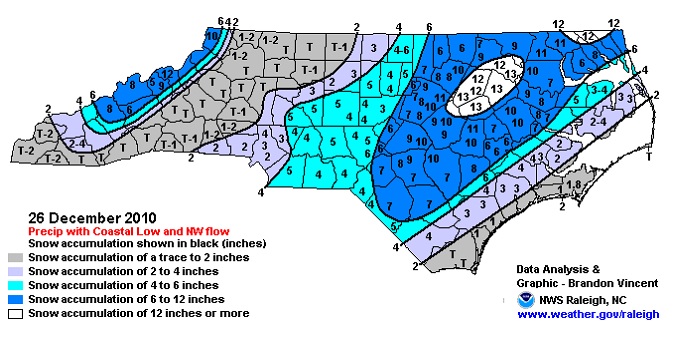
I believe they got over 6" in the Christmas/Boxing Day Storm of 2010. And before that, January 2009.
-
41 minutes ago, uncjibble said:
It just got more and more depressing so I stopped at 6! I did find this one though, proof that we can get big snow in Raleigh!
You guys did really well in January 2009, as well.
")
-
32 minutes ago, uncjibble said:
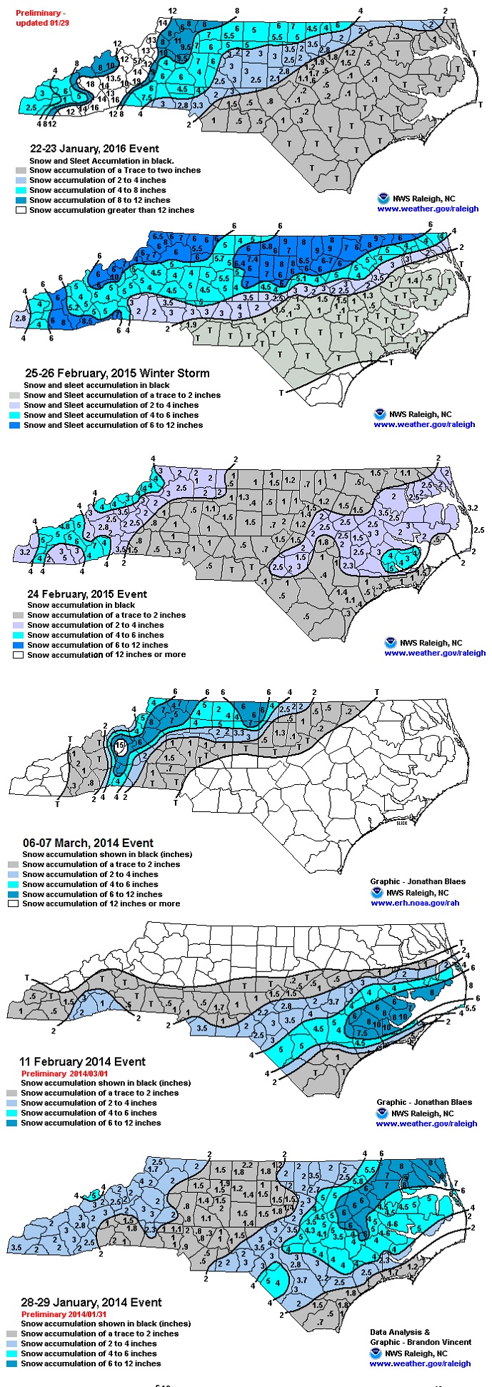
You just don't know our pain of watching snow in Raleigh! This is the last 6 major events in our area, they all have in common that they go JUST north/west or south/east of RDU. It gets frustrating seeing them so close but never hit. You have to go back to 2010 for a good hit at RDU. However, that being said, looking back, we have gotten SOMETHING almost every year. Its usually 1-1.5 inches, but we are lucky to get something every year. It just gets frustrating after a while to watch everywhere around us get the big totals as we constantly miss/fringe.
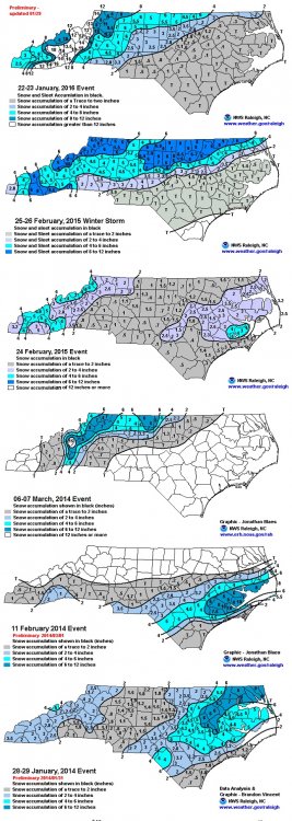
You could add January 2013, February 2012, and January 2011 to this list, as well.
-
13 minutes ago, packbacker said:
UK came in a tick NW and stronger then 12z. Waiting on QPF, but somehow the precip will be confined to east of HAT/ILM.
3-6” for DC somehow, some way with this one, you just know it.

-
19 minutes ago, weatherheels said:
The one and only thing that is giving me hope with this set up is knowing that Frosty lives to my west. That has to give me some sort of chance of seeing snow in this setup
")
A Mt. Airy jackpot is still very possible. I don't know how, but Frosty has stopped in and said that this isn't his storm and wished luck to folks to his south and east. This is usually the course things take before Frosty ends up getting snowed in.

-
 1
1
-
-
Banking on impressive ratios usually leads to disappointment. It sure doesn't look like our normal slop for most, but I wouldn't bank on much better than 10:1. Something always seems to go wrong to hamper ratios in the South, even in cold storms.
-
It’s always fun to see how much Fishel and WRAL are discussed on this board.
-
The SREFs tend to just follow whatever the previous NAM run did, in my experience.
-
I'm getting my hopes up for wintry weather and I live in Florida. This is going to end well. Ugh. What's weird is that I need a bit of a NW trend (or just take the NAM/RGEM).
Unfortunately, I can't just say "next" down here since the next legitimate threat might not happen again for years...not that I'll necessarily live here that long.
-
 1
1
-
-
Just now, mackerel_sky said:
So we've got the NAM and RGEMon our side, what could go wrong!?
I have to cherry pick what I can down here in the tropics.
-
1
-
-
Is Andy Cohen alright?
-
4 hours ago, mackerel_sky said:
It's a bone- chilling 58 degrees outside! I better start letting my faucets drip! ;(
58 is too cold for snow.
-
1
-
-
14 minutes ago, mackerel_sky said:
Oh sweet Jeebus!! Brick just passed out! Glad he's not here anymore
Oh, did he get banned?
Kinda feel like this storm might be trending towards a DC Metro bomb.
-
So the German model looks like a low-key January 2000?
Wonder what the Gambian model says?
-
Damn near a Waycross special on the 00z Euro.
-
21 minutes ago, No snow for you said:
Who knew 28 was too cold to snow in the south. We are screwed.
Pretty soon 40 will be too cold for snow in the South, and then what?
-
1
-
-
I think the 18z NAVGEM may have showed snow here based on the crude maps I looked at. Book it.
-
1
-
1
-
-
I’m feeling January 2000 vibes with this NYD event.
-
1
-
2
-
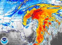
Hurricane Florence
in Southeastern States
Posted
The 00z GFS looks like a monster rainmaker for NC. Looks like 12”+ from roughly the Triad eastward. A step up from 18z and a huge step up from prior runs before 18z yesterday, especially for central NC.