
superjames1992
-
Posts
10,023 -
Joined
-
Last visited
Content Type
Profiles
Blogs
Forums
American Weather
Media Demo
Store
Gallery
Posts posted by superjames1992
-
-
This storm is looking to ruin my trip to Scarowinds Saturday night.
In other news, my old stomping lands of Tallahassee, FL look to get yet another tropical system (granges, this one is weak).
-
9 hours ago, kvegas-wx said:
Man, this is really gonna make all those yootoob hypers look silly. They might lose a few subscribers over this!


Hehe, the good news is we can still score. Last year was a torching winter, but this area and yours still ended up well above normal snowfall because of one big snowstorm. It just takes one.
Likewise, we can have a cold winter and get unlucky and end up not getting much snow, too.
-
Winter cancel.


-
Accuweather predicts a snowy winter for the Northeast. Shocking!
But a winter storm "could" hit some N/W areas of the Southeast. No, at least one wintry event of some sort is basically guaranteed in these parts (even if it's small), so it's not much of a "could", IMO.
-
Thankfully, as opposed to where I lived in Greensboro, I now live north of I-40. Unfortunately, i now live S/E of I-85. Game over! Winter cancel!!!
I wish I was here for last year's one-footer.
 I haven't seen snow in a long while...
-
 1
1
-
-
Helena, MT is forecasted to get 8-12" in a few days and the Marias Pass is forecasted 36-50". Not bad.
-
7 hours ago, griteater said:
We've been in the warm cross-hairs in the southeast since the 2011-2012 winter

Despite this, I would say winters over the last 10 years or so have been much improved over the winters of the 2000s decade. I think Greensboro, at least, may be above the 1981-2010 average snowfall average despite the sizzling temperatures.
Of course, it only take some storm around here. For example, Greensboro finished 50% above average in snowfall last year because of one storm, despite the rest of the winter being irredeemably terrible (aside from the surprise snowfall in April).
I am looking forward to this winter after having lived in Florida the last three winters...
-
3 hours ago, frazdaddy said:
I meant it's just possible he is already here.
I think he posts under the username Brick Tamland.
-
 2
2
-
-
26 minutes ago, StantonParkHoya said:
I said days ago that if it made landfall at all, it would be cat 1 at best. So I’m not wrong.
Congratulations. We’ve got a budding weather savant.
-
2
-
-
On 9/1/2019 at 10:59 AM, superjames1992 said:
I have some extended stepfamily who lives in Man-O-War near Marsh Harbor in The Bahamas and decided not to evacuate. WTF??? Hope they survive...
To follow up on this, they did survive. Their house, however, did not, to say the least. Just saw a photo of it and there’s hardly anything left.
-
1
-
-
Beautiful weather this weekend.
-
6 minutes ago, Flying Bouncy House said:
They certainly are, but other than the short-term track, there hasn't been much consistency in the models. I would be very concerned with the Ukies, but we won't know until it progresses through the islands. If it hasn't started turning NW by then, all bets are off and the panic will set in. This is crazy stuff to watch, like the worst possible reality show you could imagine.
It’s definitely important to remember a Florida landfall is well within range of a “typical forecast error” 48 hours out.
-
2
-
-
1 minute ago, Flying Bouncy House said:
If the models don't predict rapid intensification, and any wobble or interaction with land mass could impact direction, I wouldn't discount any solution that has a Florida landfall. I do see a couple ticks north on the satellite, but could wobble south again as the center moves over the islands.
Hurricane intensity forecasts are always a crapshoot, though. Michael wasn’t supposed to get nearly as strong as it did right before landfall in the FL panhandle last year, either.
-
I have some extended stepfamily who lives in Man-O-War near Marsh Harbor in The Bahamas and decided not to evacuate. WTF??? Hope they survive...
-
 1
1
-
-
I have some extended stepfamily who lives in Man-O-War near Marsh Harbor in The Bahamas and decided not to evacuate. WTF??? Hope they survive...
-
12z ICON is a Miami hit. Is that model worthless for tropical weather? Odd to see.
-
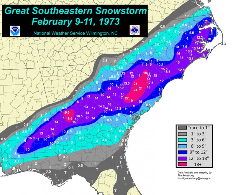
1 hour ago, FallsLake said:
There's your history....Storms just don't want to make landfall in central Florida to the SC/Ga boarder. Of course it's not them specifically, it's the upper air patterns (at that latitude) recurving the storm from westward to eastward motion. Only problem is the SC/NC coast line juts out too much for the recurve to miss (sometimes).
To illustrate this:

-
1
-
-
The 00z GFS appears to be keeping it pretty far offshore of FL. I’m not sure it’s going to make landfall anywhere on the 00z.
EDIT: Looks like it might try to make landfall northeast of KCHS, actually.
-
2 hours ago, Solak said:
CAT 4, 130mph at 8:30PM
Up to 140 mph as of 11 pm now. And the center of the new NHC cone doesn’t even make landfall in FL as the cone shifts east. Looks strangely Matthew-like.
-
1 hour ago, Typhoon Tip said:
You may just be in hyperbole there but we are definitely close to any rank inside of top 10
Yes, but it was basically a guarantee that any year is going to be a top 5-10 melt season given the long-term trend. That’s what I mean by “new normal”.
-
1
-
-
Pretty crazy turnaround considering how bad things looked a few weeks back. I mean, historically the minimum is still going to be low, but we're not going to even come close to 2012 and it looks like it's not going to be too far out of the ordinary for our "new normal" in the arctic.
-
Just now, Cheeznado said:
The Euro has no US landfall.
It does a Hurricane Matthew or something?
-
I guess the good news about a quicker turn right is that the Florida panhandle will likely be spared another hit after Michael last year. It was looking like it could still be pretty strong well inland or even enter into the Gulf at one point.
-
On 8/21/2019 at 1:04 PM, FallsLake said:
I've heard this winter we're going to get storm after storm that follows this path:
I think it was this one, actually?


-
1
-
Arctic Sea Ice Extent, Area, and Volume
in Climate Change
Posted
I thought this was an arctic sea ice thread?