
superjames1992
-
Posts
10,023 -
Joined
-
Last visited
Content Type
Profiles
Blogs
Forums
American Weather
Media Demo
Store
Gallery
Posts posted by superjames1992
-
-
3 hours ago, Touchet said:
Does anyone really know what is gonna happen Tuesday?
No, but we’ll know on Wednesday.
")
—-
On a serious note, this looks like rain chasing the moisture east of the Appalachians, which usually never turns out well. The models do seem to favor a period of snow for the NC Piedmont, though, so we’ll see. Looks like a better storm for N MS/AL/GA.
-
My winter checklist is a single flake of snow falling from the sky. I don't think that's going to happen, though. At least I saw snow on the ground when I went skiing, I guess?
I actually got to see it snow twice last year (here in Tallahassee with our "historic" dusting in early January and about 1" in Greensboro while visiting in late March). I also saw it snow while I was on a vacation in Scandanavia in May 2017. But this winter I might get shut out.

-
2 hours ago, eyewall said:
30's and cold rain is as miserable as it gets. This was a morale crusher in Raleigh.
At least the DC metro is getting theirs, though, am I right?
")
-
Correct me if I'm wrong, but I want to say the CMC is sometimes a little cold at the surface in the mid/long-range, so it could be overdoing the ice threat. Or at least that's what I remember from years ago. It might've changed.
Of course, other modeling can tend to run too warm in CAD situations.
-
I miss snow.
At least I saw a few remnant dirty snowpiles from the December storm when I was in Greensboro over Christmas.
And now they look to be getting another...
-
Merry Christmas. Clipper love.

I’m all-in.

-
6 hours ago, kvegas-wx said:
I want everyone here to get their snow so dont take this the wrong way, but I never want to see over a foot of snow again. I think 4" is about right. Coat everything, cover the grass, you can walk in it, drive in it, shovel it fairly easily, businesses stay open and it melts quick. The order of magnitude increase in complexity of everything with the limited snow removal resources here in the south is unreal.
The ideal winter for me going forward is 3-4 4" inch events with one of them being Christmas morning. A foot is cool if you dont actually have to function for 3-4 days.
BAN BAN BAN BAN BAN BAN BAN!!!!!!!!!
I know what you mean, though...but I'll still take the big snows and all the encompassing hell that goes along to it. Still waiting for my first foot of snow since January 2000. I need to move. Maybe if I move to Charlotte the city will start seeing snow again?
-
9 minutes ago, Queencitywx said:
I was thinking 86-87(actually I was fairly certain about that one) but was on the fence about the others. I usually go on the premise of you usually get one shot at a good one around here per year and we’re not even really in winter.
Yeah, it’s pretty rare to get two 6”ers. You can find a lot of examples of multiple 2-4” storms, but not many multiple 6” storms. 6” storms are “big storms” in NC outside the mountains, so they don’t happen that commonly.
-
6 hours ago, CyclonicFury said:
I wonder what's in store for the rest of the winter in central NC. 7.5" is very impressive for early December.
I think next up is the FL panhandle crusher to surpass the Great Blizzard of 1899 and the 1958 storm.

-
11 minutes ago, mryanwilkes said:
How tall is Cantore? Looks pretty short...but you might be tall.
I’m pretty sure Cantore is pretty short from other photos/videos I’ve seen of him.
-
1 hour ago, GreensboroWx said:
Often, upper lows, which are cold aloft in nature, over perform and are not well handled by the models. See Lubbock, Tx..... I wouldn't discount the NAM 3K.
Remember that ridiculous upper level low in February 2014 that gave the foothills and SW VA a surprise 8”-12”+ of snow (on top of the big snow they had already had)? It wasn’t quite as prolific in Greensboro, but we got a bonus inch from that, too (to bring our storm total to about 8”).
-
2 hours ago, Queencitywx said:
With us just beginning winter, I wonder how many piedmont locations have had multiple snows of 6"+ in a winter.
Looks like some areas in the foothills (edit: I meant Sandhills, oops) accomplished this in 2010-2011 (Boxing Day storm and the January 2011 storm). Also, some areas of the NW Piedmont did so in 2009-2010 (12/29 storm and the 1/30 storm). I suspect several locations accomplished this feat during the winter of 1986-1987.
-
42 minutes ago, magpiemaniac said:
Light freezing rain on top of 12” of snow and 30F in GSO.
I took a short drive in the truck and the roads are pretty bad. (Obviously.) Neighborhood streets are impassable for most vehicles and main roads are rough. Only one lane each direction on Friendly and still slick after plowing. High snow banks from the plows leading onto neighborhood streets.
There’s going to be some epic snow piles. I remember after January 2000 there was still a massive snow pile in the parking lot at the coliseum well into spring.
-
38 minutes ago, JoshM said:
Merry Christmas!

I’m going to be in Greensboro, NC for Christmas. I need this.
-
 2
2
-
 1
1
-
-
5 minutes ago, norcarolinian said:
Just north of the sleet band here. Huge flakes just ripping. Between 13-14” here now
I just looked at GSO's OBS and it looks like they're over 2.3" liquid equivalent so far. No wonder this thing is such a monster. That's an amazing about of moisture. That includes 0.86" in a single hour from 7-8 AM. Could that be right or is that an error? That liquid equivalent seems off the charts for snow in one hour, so it seems a little suspect, but regardless this thing is juiced.
Anyways, looks like another case where N/W always wins in the Triad, LOL. Seems like you should pick up a few more inches than GSO-proper, most likely (though that was expected).
-
6 minutes ago, TriadDeac said:
NW High Point
12”
Light snow / sleet mix
Very windy at times
Absolutely gorgeous Winter Wonderland...
My parents just sent a picture from NE High Point. They didn’t measure, but it looks like more snow than I ever saw in a storm at that house in my time there and looks like a foot or so. Amazing. It’ll be interesting to see what the liquid equivalent ends up being in GSO. Wouldn’t be surprised if it’s approaching 2”.
Anyways, no snow here. At least it’s warm, I guess, LOL......
-
1
-
-
Just talked to my parents in northern High Point, NC (near the GSO airport). They have power, but cable/internet are out.
-
1 hour ago, Dunkman said:
Just want to say I'm glad we can go back to treating the NAM like crap. This new world in which it was a trustworthy and respectable model was not a place I was comfortable living.
I think it seems to have done a decent job still, though? It still generally showed a good storm for GSO, but it seems to have nailed CLT’s sleet/ZR fest. At least the warm nose isn’t over performing this time. Seems like Durham is really doing better than expected, too.
Anyways, looks like 10”+ there, which would have been my biggest storm since 2002. Quite possibly 12”+, which would have been the biggest storm I’ve ever experienced. Finally, a storm where the crazy QPF forecasts actually happen!
I’ll have to talk to my parents later and see what it looks like there.
-
1
-
-
Seems to be doing a little better than I expected in GSO. It will be interesting to see what the airport ends up reporting (close to where I used to live). I’d expect INT to do better than GSO, as well. It seems that the forecasted QPF has turned out to be fairly accurate.
My OBS: 64/OV.
-
The precip was supposed to have a hard time moving north. The mid levels are pretty dry (fortunately so or else they wouldn’t wet bulb low enough for snow). Things seem to be progressing as expected regarding the precip as far as I can tell. It should start to hammer later tonight.
-
5 minutes ago, Brick Tamland said:
One NAM run
Every NAM run for the last three days has been showing a problematic mid-level warm nose. Maybe it’ll be wrong (I don’t think so since it is usually good at sniffing those out), but it’s been pretty consistent.
At least the NAM has a lot of QPF to work with. NW NC/SW VA are going to get rocked.
-
2
-
-
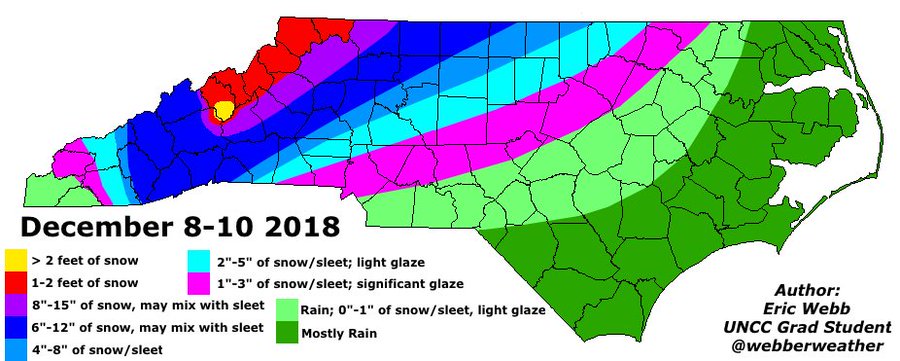
WebberWeather’s final call, FWIW:
https://mobile.twitter.com/webberweather/status/1071584244286308353/photo/1
-
Won’t take much of a shift to get the DC metro in the game. Roanoke looks to cash in as usual!
The 00z NAM has a brutal warm nose, on first glance. It’s had this all along.
-
3 minutes ago, Tigerchick224 said:
It most certainly is. Everything about this geographic area is ridiculously complex. I recall a storm I think in 2011 (?) that was mostly snow and I’m wondering if that had a warm nose issue at all. That storm was directly after the white Christmas we had, just a few weeks earlier.
.
You’re talking about the January 2011 system. The funny thing about that one was that it was mostly sleet/freezing rain in central NC.
https://www.weather.gov/media/gsp/localdat/cases/2011/Snow%26FrzgRain_10 Jan11.pdf
-
1
-
Southeast Sanitarium - A Place to Vent
in Southeastern States
Posted
Don't you forget about Amazing April and Splendid Spring. April snows will save winter.