

CT Valley Snowman
-
Posts
5,203 -
Joined
-
Last visited
Content Type
Profiles
Blogs
Forums
American Weather
Media Demo
Store
Gallery
Everything posted by CT Valley Snowman
-
 I'm fine with 4.5" here. No need for high water table/basement flooding issues.
 -
1.06 yesterday at a nearby PWS. I'm fine with that. No need for flooding.
-
Saturday, July 18, 2026 Thunderstorm/Severe Weather Potential
CT Valley Snowman replied to weatherwiz's topic in New England
Just seemed like a messy convective mode all day. Back home now from the Maine woods to horrible air quality and likely another severe fail. -
Saturday, July 18, 2026 Thunderstorm/Severe Weather Potential
CT Valley Snowman replied to weatherwiz's topic in New England
Not a big recovery window and pretty late iin the day to recover. Rains still out to almost BGM. -
No large pines that I could see, at least around Russ Pt Road. Definitely some branches. It's always nerve-wracking watching them swaying near our cabin in strong winds.
-
Power back on here at 7:10 PM. I hit a couple of détours trying to get back to Flying Pond on 41 from Farmington due to downed trees and wires.
-
Took 134 to the New Sharon Dunkin Donuts a few times this week. Hard to beat the views as far as a quick car ride is concerned. Taking the kids to hike Bald Mountain Preserve in Camden tomorrow morning. Usually it's Bald Mountain or Mt Blue in Weld, but I'm out of hiking shape and we are looking to try something a bit different outside of the Kennebec Highlands trails near us.
-
Family cabin on Fying Pond
-
Meh here so far in Mt. Vernon Maine. A few rumbles now, a bit of thunder, a flash of lighting. and some light rain earlier.
-
Seems like wagons SW as far as NW Maine is concerned.
-
Yeah tons of clouds and smoke here in Maine. Temps are underperforming.
-
Starting to get interested in this up in Maine on vacation. Being in the woods at a cabin surrounded by huge trees. Easy to lose power at this location.
-
Keeping an eye on Tuesday night up here in Maine for bangers. Hopefully the timing can speed up to take advantage of max instability because other parameters are impressive.
-
Party's over as the rain and storms are rolling in here in Maine after being dry since last Friday when we arrived.
-
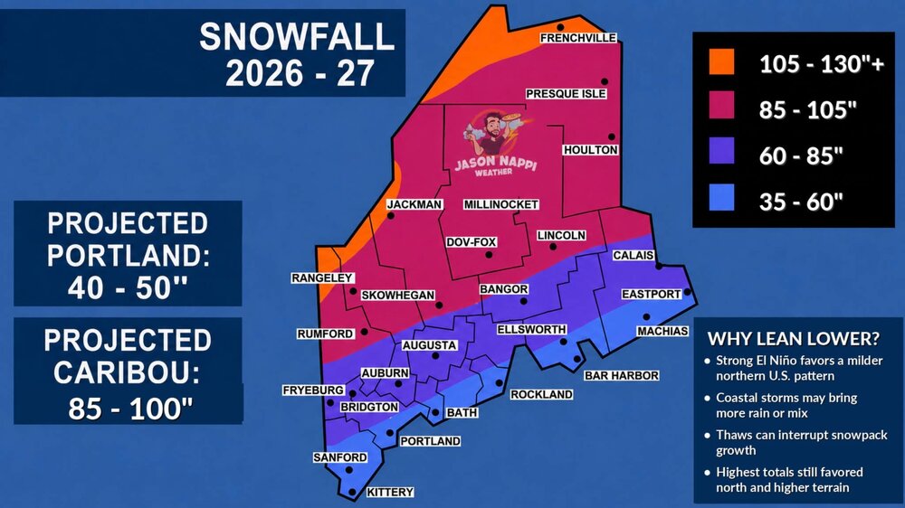
Here ya go, Mainers, lol. Courtesy of Jason Nappi.
-
Hoisting the Sultan Signal: Heavy Rain Event July 5-7
CT Valley Snowman replied to WxWatcher007's topic in New England
Looks like today really saved the event from a bust back home Closing in on 2.5 at a local PWS. -
Hoisting the Sultan Signal: Heavy Rain Event July 5-7
CT Valley Snowman replied to WxWatcher007's topic in New England
I'm very happy. Not a drop here in Maine for vacation. Maximizing lake activities and keeping tents and outdoor things dry while at the same time knowing we got a good drink back home to alleviate the burnt dry vegetation. -
Hoisting the Sultan Signal: Heavy Rain Event July 5-7
CT Valley Snowman replied to WxWatcher007's topic in New England
Looks like I've crept just over 2" in my area. I'll take that and run. -
Hoisting the Sultan Signal: Heavy Rain Event July 5-7
CT Valley Snowman replied to WxWatcher007's topic in New England
Looks like a bit over 1" now at home. Nothing too heavy, just a nice soaking rainfall to help alleviate the dry conditions. -
Hoisting the Sultan Signal: Heavy Rain Event July 5-7
CT Valley Snowman replied to WxWatcher007's topic in New England
This is what we are. A very good but not top level team. Can't make mistakes like they did tonight and expect to beat a top 10 team. -
Hoisting the Sultan Signal: Heavy Rain Event July 5-7
CT Valley Snowman replied to WxWatcher007's topic in New England
There is a decent amount of modeling showing a secondary north push. Time will tell. When it's all said and done, the southern half of CT will likely do the best. I think Enfield ends up around 1-1.25", which in the end, is a nice beneficial rainfall. I'd like to get up there 2" or more ,but I'm not really sold on that yet. -
Hoisting the Sultan Signal: Heavy Rain Event July 5-7
CT Valley Snowman replied to WxWatcher007's topic in New England
.71 in Enfield with precip about to temporarily shut down in northern ct. This always favored the southern half of the state for the biggest totals. Northern CT, as of now, looks like a a beneficial rainfall but nothing earth shattering. Nice banding along 84 SW of Hartford. -
Hoisting the Sultan Signal: Heavy Rain Event July 5-7
CT Valley Snowman replied to WxWatcher007's topic in New England
Looks like cloae to .65 near my house. Definitely north of the best action. -
Hoisting the Sultan Signal: Heavy Rain Event July 5-7
CT Valley Snowman replied to WxWatcher007's topic in New England
Looks like about .45 so far at home. Nice day up in Maine. -
Hoisting the Sultan Signal: Heavy Rain Event July 5-7
CT Valley Snowman replied to WxWatcher007's topic in New England
1.66 since June 1 at a nearby PWS in Enfield. Let's see how this works out.


