

Spartman
-
Posts
909 -
Joined
-
Last visited
Content Type
Profiles
Blogs
Forums
American Weather
Media Demo
Store
Gallery
Posts posted by Spartman
-
-
321 SXUS71 KILN 282101 RERDAY RECORD EVENT REPORT NATIONAL WEATHER SERVICE WILMINGTON OH 502 PM EDT SAT SEP 28 2019 ...RECORD HIGH TEMPERATURE TIED AT DAYTON OH TODAY... A HIGH TEMPERATURE OF 91 DEGREES WAS RECORDED AT THE DAYTON INTERNATIONAL AIRPORT (DAY) TODAY. THIS TIES THE OLD DAILY RECORD OF 91 DEGREES LAST SET IN 1905.
Tied a record of 91.
Supposed to reach only the low-80s or even cooler for a day tomorrow due to expected cloud cover.
-
Managed to hit 90 for at least one more time for this year after being 89'd the past couple of days.
-
Topped out at 94, the highest temperature it will likely go this year.
-
 1
1
-
-
-
Storm system that is supposed to come Monday through Tuesday looks rather fall-like (mainly on Monday). GFS over the past few runs has highs only in the low to mid 60s while the Euro has highs only reaching up to the low 70s during the day on Monday.
-
1
-
-
-
Fifty shades of July 2009 over the next few days after tomorrow.
 Models have been consistent over the past several days on storms that develop later tomorrow which is a precursor to a fall-like storm that is expected during the day on Monday. TWC is currently forecasting a high of only 74. Ironically, this is exactly on the 10th anniversary of the soaker that was an all-day washout and resulted in a record low maximum temperature of 69 degrees and rainfall total of 1.51 inches which occurred on July 22, 2009.
-
Topped out at 93. Likely the highest it'll be for this year, just like last year.
-
Topped out at 92 in DAY, CVG, and CMH.
-
Didn't expect to hit 90 for the 6th time today.
-
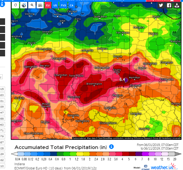
390 CXUS51 KILN 010644 CF6DAY PRELIMINARY LOCAL CLIMATOLOGICAL DATA (WS FORM: F-6) STATION: DAYTON OH MONTH: JUNE YEAR: 2019 LATITUDE: 39 54 N LONGITUDE: 84 12 W TEMPERATURE IN F: :PCPN: SNOW: WIND :SUNSHINE: SKY :PK WND ================================================================================ 1 2 3 4 5 6A 6B 7 8 9 10 11 12 13 14 15 16 17 18 12Z AVG MX 2MIN DY MAX MIN AVG DEP HDD CDD WTR SNW DPTH SPD SPD DIR MIN PSBL S-S WX SPD DR ================================================================================ 1 82 60 71 5 0 6 0.00 0.0 0 9.9 21 230 M M 4 35 30 2 75 55 65 -2 0 0 0.15 0.0 0 11.3 26 300 M M 4 13 39 290 3 73 51 62 -5 3 0 0.00 0.0 0 4.8 12 290 M M 3 14 280 4 81 55 68 1 0 3 0.00 0.0 0 8.7 18 210 M M 7 23 220 5 82 66 74 6 0 9 0.07 0.0 0 11.1 23 230 M M 8 13 29 250 6 83 64 74 6 0 9 0.00 0.0 0 6.3 16 30 M M 8 18 20 30 7 79 62 71 3 0 6 0.00 0.0 0 11.1 21 50 M M 9 18 26 60 8 79 66 73 4 0 8 T 0.0 0 14.6 26 110 M M 9 31 100 9 78 66 72 3 0 7 0.14 0.0 0 11.8 21 130 M M 9 1 26 130 10 75 56 66 -3 0 1 0.61 0.0 0 12.7 26 310 M M 7 18 37 300 11 79 50 65 -5 0 0 0.00 0.0 0 5.1 13 70 M M 3 16 110 12 79 57 68 -2 0 3 0.03 0.0 0 10.2 20 160 M M 6 3 26 150 13 64 53 59 -11 6 0 0.08 0.0 0 17.3 41 290 M M 9 13 53 290 14 76 50 63 -7 2 0 0.00 0.0 0 12.5 20 210 M M 4 25 230 15 73 63 68 -3 0 3 1.52 0.0 0 10.8 24 250 M M 10 1 30 230 16 81 68 75 4 0 10 0.09 0.0 0 11.4 24 210 M M 8 13 29 210 17 78 68 73 2 0 8 0.40 0.0 0 6.0 17 220 M M 10 13 22 220 18 84 66 75 3 0 10 T 0.0 0 3.3 13 230 M M 9 123 15 240 19 84 69 77 5 0 12 0.06 0.0 0 5.6 16 260 M M 9 18 22 250 20 74 63 69 -3 0 4 0.11 0.0 0 14.6 29 270 M M 9 18 37 270 21 79 59 69 -3 0 4 T 0.0 0 5.2 9 150 M M 5 8 12 280 22 78 64 71 -1 0 6 0.05 0.0 0 7.8 15 80 M M 7 18 100 23 83 61 72 -1 0 7 0.09 0.0 0 8.4 20 230 M M 6 3 24 240 24 81 69 75 2 0 10 0.23 0.0 0 10.8 20 250 M M 8 1 25 220 25 84 63 74 1 0 9 0.00 0.0 0 11.3 22 260 M M 3 29 250 26 89 68 79 6 0 14 0.00 0.0 0 9.7 16 230 M M 4 8 19 270 27 89 71 80 7 0 15 0.17 0.0 0 6.4 21 310 M M 6 3 27 320 28 91 68 80 6 0 15 0.00 0.0 0 7.5 16 270 M M 4 19 240 29 92 71 82 8 0 17 0.00 0.0 0 10.1 18 230 M M 3 23 270 30 90 73 82 8 0 17 0.00 0.0 0 8.3 16 330 M M 5 19 360 ================================================================================ SM 2415 1875 11 213 3.80 0.0 284.6 M 196 ================================================================================ AV 80.5 62.5 9.5 FASTST M M 7 MAX(MPH) MISC ----> # 41 290 # 53 290 ================================================================================ NOTES: # LAST OF SEVERAL OCCURRENCES COLUMN 17 PEAK WIND IN M.P.H. PRELIMINARY LOCAL CLIMATOLOGICAL DATA (WS FORM: F-6) , PAGE 2 STATION: DAYTON OH MONTH: JUNE YEAR: 2019 LATITUDE: 39 54 N LONGITUDE: 84 12 W [TEMPERATURE DATA] [PRECIPITATION DATA] SYMBOLS USED IN COLUMN 16 AVERAGE MONTHLY: 71.5 TOTAL FOR MONTH: 3.80 1 = FOG OR MIST DPTR FM NORMAL: 0.9 DPTR FM NORMAL: -0.37 2 = FOG REDUCING VISIBILITY HIGHEST: 92 ON 29 GRTST 24HR 1.52 ON 15-15 TO 1/4 MILE OR LESS LOWEST: 50 ON 14,11 3 = THUNDER SNOW, ICE PELLETS, HAIL 4 = ICE PELLETS TOTAL MONTH: 0.0 INCH 5 = HAIL GRTST 24HR 0.0 6 = FREEZING RAIN OR DRIZZLE GRTST DEPTH: 0 7 = DUSTSTORM OR SANDSTORM: VSBY 1/2 MILE OR LESS 8 = SMOKE OR HAZE [NO. OF DAYS WITH] [WEATHER - DAYS WITH] 9 = BLOWING SNOW X = TORNADO MAX 32 OR BELOW: 0 0.01 INCH OR MORE: 15 MAX 90 OR ABOVE: 3 0.10 INCH OR MORE: 8 MIN 32 OR BELOW: 0 0.50 INCH OR MORE: 2 MIN 0 OR BELOW: 0 1.00 INCH OR MORE: 1 [HDD (BASE 65) ] TOTAL THIS MO. 11 CLEAR (SCALE 0-3) 3 DPTR FM NORMAL -11 PTCLDY (SCALE 4-7) 16 TOTAL FM JUL 1 5302 CLOUDY (SCALE 8-10) 11 DPTR FM NORMAL -340 [CDD (BASE 65) ] TOTAL THIS MO. 213 DPTR FM NORMAL 23 [PRESSURE DATA] TOTAL FM JAN 1 335 HIGHEST SLP 30.25 ON 11 DPTR FM NORMAL 75 LOWEST SLP 29.56 ON 20 [REMARKS] #FINAL-06-19#In addition to the first few 90s of the year, the first precipitation-free weekend since February 2-3 (and third precipitation-free weekend of this year) was a very good way to end June. After 7 consecutive months of above-normal precipitation, June ended up drier-than-normal at DAY which was the first time since last October.
-
-
6 hours ago, Chicago Storm said:
89'd again today. Oh the horror.
Thanks to nearby convection that made temps hit a brick wall literally minutes after reaching 89. Interesting fact that DAY, CVG, and CMH all have not hit 90, so far this month.
-
89'd today at DAY, highest temperature so far this year. Have a feeling it may be the highest it's going to get for this June.
-
1
-
 1
1
-
-
Only topped out at 73 degrees. Highest temperature hit so far this month is 83 degrees back on the 6th. The record low maximum June temperature is 84 degrees in 1982. Currently, there have been only 7 years where the highest temperature of any June would be colder than the highest temperature of any May: 1896, 1903, 1928, 1929, 1937, 1938, and 1982.
-
Topped out at 76 today after only reaching 64 degrees as an overnight high yesterday. Might as well struggle to even reach the 70s tomorrow due to the storms and no sun. TWC wants both tomorrow (with high of 73) and Sunday (highs in lower 80s) to be washouts. Definitely going to be a crappy weekend.
-
46 minutes ago, Hoosier said:
From what I've seen, most outlets are calling for a warmer than average summer, with June perhaps being coolest relative to average. Of course there's multiple ways to get there... some high end heat spells or just consistently warmer than average (especially with lows) or warm stretches just outweighing the cool ones. I do think that if the pattern does not begin to dry out, it will be tougher to build intense heat to the west.
June is probably going to be a write-off. With the highest temperature of the year so far at 88 degrees just over a week ago (May 25th), it's going to take until at least next month to try to exceed it.
-
4 hours ago, janetjanet998 said:
12z GFS still very wet later next week with that cut off low ejecting out and sucking up huge amounts of tropical moisture
also poorly modeled heavy warm core rains often fall on the North and NW flanks..sort of like a TROWAL .and it is expected to almost stall
4 hours ago, CoalCityWxMan said:Seems like these sorts of scenarios give this region its heaviest rains, could be bad if it plays out as modeled.
Lock it in! :sarcasm:
1 hour ago, janetjanet998 said:EURO brings in a big blocking high in from the north shoving the system back south..it basically stalls over AR days 6-10..
dumps large amounts over lower OH river into AR/OK more south then 00z run
of course it will change
As for the current EURO run:
 2 hours ago, Jonger said:
Hey look... more rain!
Will it ever take a break.
DAY has not had a drier-than-normal month since last October. If June ends up like the past several months, it would be the 8th consecutive month with above-normal precipitation. Using 1961-1990 normals, the longest stretch of above-normal precipitation that I could find for DAY was 11 consecutive months that took place from January through November of 1993, which December of that year was the only month with below-normal precipitation. Something tells me there has never been a year where every single month of a calendar year recorded above-normal precipitation, nor has there been a stretch of above-normal precipitation of 12 consecutive months or more.
-
Just as expected, this May was the 7th consecutive month with above-normal precipitation ending with a total of 6.06".
-
Only reached 52. The record low maximum temperature for today is 48 in 1960. Could very well top the same or just below tomorrow with NWS only forecasting highs in the mid 50s. The record low maximum temperature for tomorrow is 49 in 1914. Come on already, Tuesday! #blackberrywinter
-
Had an early high of 66 after midnight followed by overcast skies and temps in the 50s through the day, might as a well get a crappy weekend.
-
The Little Rain Age continues into this new month. If it holds true, I can see this as DAY's 7th consecutive month with above-normal precipitation. -
Although warmer than normal, April ended slightly wetter than normal with a total of 4.22" for the month. It marks the 6th consecutive month at DAY with above-normal precipitation.
-
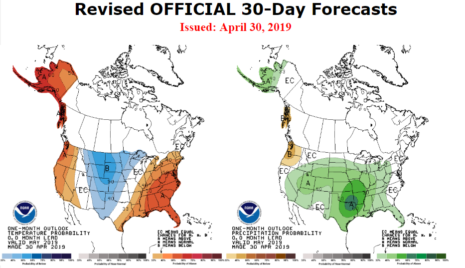
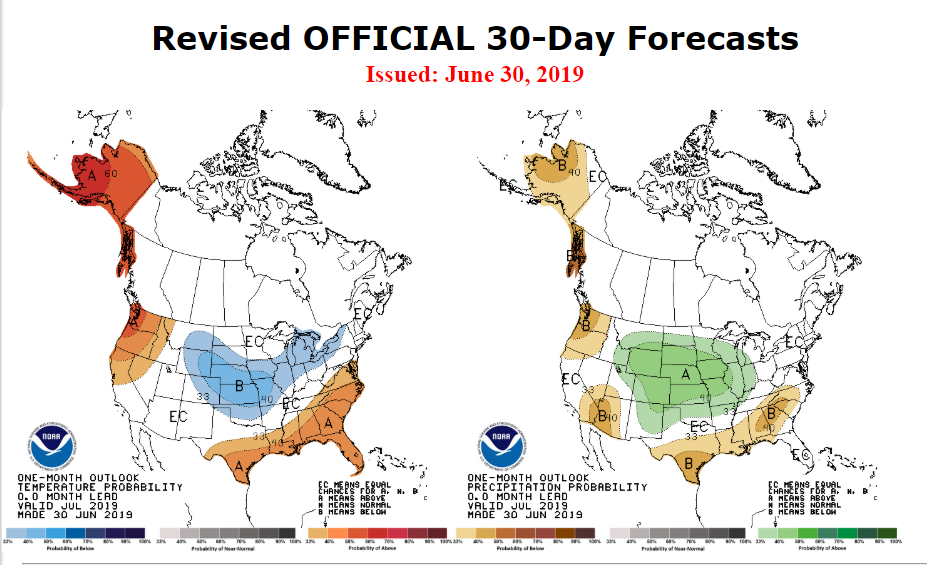
Final March 2019 outlook from CPC:


September 2019 General Discussion
in Lakes/Ohio Valley
Posted
002
SXUS71 KILN 302148 CCA
RERDAY

RECORD EVENT REPORT...CORRECTED FOR OLD RECORD YEAR
NATIONAL WEATHER SERVICE WILMINGTON OH
550 PM EDT MON SEP 30 2019

...RECORD HIGH TEMPERATURE TIED AT DAYTON OH TODAY...

A HIGH TEMPERATURE OF 94 DEGREES WAS RECORDED AT THE DAYTON
INTERNATIONAL AIRPORT (DAY) AT 422 PM EDT TODAY. THIS TIES THE OLD
DAILY RECORD FOR THIS DATE OF 94 DEGREES SET IN 1897.