

Spartman
-
Posts
929 -
Joined
-
Last visited
Content Type
Profiles
Blogs
Forums
American Weather
Media Demo
Store
Gallery
Posts posted by Spartman
-
-
-
1 hour ago, Baum said:
going to be a brutal back half of January. Rest up, if you love winter weather. Lot of model watching coming.
Current Teleconnections:


12z GFS:
18z GFS:
-
 3
3
-
 1
1
-
-
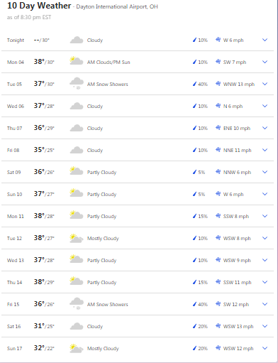
Looks like we're fixing for the cloudiest stretch of the season this week, lasting at least a week, just like during the final third of last January. January 1992 certainly had one of the cloudiest starts to the month in history. Come on, 2nd half of January!
-
6-10 day:


8-14 day:


-
1
-
-
Narrow temperature band during the 1st third of this January. Here's to another last January.
-
-
The wet and overcast New Year's Day this year marks the start of the long crappy New Year's weekend. Suicide weather tomorrow followed by more rain Sunday. Fifty shades of January 2020 on the horizon over the next 1-2 weeks.
-
000
CXUS51 KILN 010551
CF6DAY
PRELIMINARY LOCAL CLIMATOLOGICAL DATA (WS FORM: F-6)

                                          STATION:   DAYTON OH
                                          MONTH:     DECEMBER
                                          YEAR:      2020
                                          LATITUDE:   39 54 N
                                          LONGITUDE:  84 12 W

  TEMPERATURE IN F:       :PCPN:    SNOW:  WIND      :SUNSHINE: SKY     :PK WND
================================================================================
1   2   3   4   5  6A  6B    7    8   9   10  11  12  13   14  15   16   17  18
                                     12Z  AVG MX 2MIN
DY MAX MIN AVG DEP HDD CDD  WTR  SNW DPTH SPD SPD DIR MIN PSBL S-S WX    SPD DR
================================================================================

 1  32  29  31  -5  34   0 0.06  1.4    2 17.7 26 270   M    M  10 1      35 270
 2  40  25  33  -3  32   0 0.00  0.0    2 10.7 16 260   M    M   2        22 270
 3  39  25  32  -3  33   0 0.00  0.0    T  8.9 15 190   M    M   7        18 190
 4  47  31  39   4  26   0 0.00  0.0    T  8.6 14 190   M    M   5        17 200
 5  41  31  36   2  29   0 0.00  0.0    0  8.3 14 320   M    M   6 1      17 360
 6  37  26  32  -2  33   0 0.00  0.0    0  6.2 14  20   M    M   9        16  20
 7  34  30  32  -2  33   0 0.00  0.0    0  8.0 14 320   M    M  10        17 330
 8  39  24  32  -1  33   0 0.00  0.0    0  8.1 17 200   M    M   8        23 220
 9  53  32  43  10  22   0 0.00  0.0    0  9.9 18 250   M    M   4 18     23 250
10  57  29  43  10  22   0 0.00  0.0    0  6.3 13 140   M    M   2 18     15 150
11  63  40  52  20  13   0 0.00  0.0    0 11.5 18 200   M    M   6        23 210
12  62  43  53  21  12   0 0.05  0.0    0 17.1 32 230   M    M   9 1      38 220
13  43  34  39   7  26   0    T  0.0    0  7.0 17 260   M    M  10        22 270
14  39  22  31   0  34   0 0.00  0.0    0  8.4 20 310   M    M   8        24 300
15  37  21  29  -2  36   0 0.00  0.0    0  7.0 14  80   M    M   7        17 100
16  34  28  31   0  34   0 0.11  1.1    T  7.2 13 100   M    M  10 1      17  70
17  32  28  30   0  35   0 0.02  0.4    1  7.4 13 280   M    M  10 16     15 290
18  38  26  32   2  33   0    T    T    1  5.9 13 210   M    M   8 18     15 160
19  42  30  36   6  29   0 0.11  0.0    0 11.4 20 190   M    M   9 1      25 200
20  42  33  38   8  27   0 0.03  0.0    0  9.8 18 240   M    M   9 1      22 250
21  44  35  40  10  25   0 0.04  0.0    0 13.5 24 290   M    M   9 1      33 270
22  44  30  37   8  28   0 0.00  0.0    0 11.7 22 290   M    M   7        29 300
23  56  32  44  15  21   0    T  0.0    0 16.2 30 180   M    M   8        41 170
24  51  15  33   4  32   0 0.05  0.1    0 15.9 31 190   M    M  10 18     42 190
25  18  14  16 -13  49   0 0.03  0.5    T 16.9 26 250   M    M   9 18     32 250
26  35  14  25  -4  40   0 0.00  0.0    T 12.1 22 220   M    M   4        29 230
27  52  21  37   9  28   0    T  0.0    0 13.5 32 220   M    M   8        42 220
28  51  29  40  12  25   0    T  0.0    0 13.9 33 220   M    M  10        44 230
29  37  20  29   1  36   0 0.00  0.0    0  8.6 21 140   M    M   6        28 130
30  50  32  41  13  24   0 0.48  0.6    0 14.6 24 300   M    M   9 1      31 310
31  33  25  29   1  36   0 0.00  0.0    1  8.2 16 320   M    M   9        21 290
================================================================================
SM 1322  854       920   0  0.98  4.1    330.5          M      238
================================================================================
AV 42.6 27.5                              10.7 FASTST   M    M   8    MAX(MPH)
                                 MISC ---->    33 220                 44 230
================================================================================
NOTES:
# LAST OF SEVERAL OCCURRENCES

COLUMN 17 PEAK WIND IN M.P.H.

PRELIMINARY LOCAL CLIMATOLOGICAL DATA (WS FORM: F-6) , PAGE 2

                                          STATION:   DAYTON OH
                                          MONTH:     DECEMBER
                                          YEAR:      2020
                                          LATITUDE:   39 54 N
                                          LONGITUDE:  84 12 W

[TEMPERATURE DATA]      [PRECIPITATION DATA]       SYMBOLS USED IN COLUMN 16

AVERAGE MONTHLY: 35.1   TOTAL FOR MONTH:   0.98    1 = FOG OR MIST
DPTR FM NORMAL:   3.9   DPTR FM NORMAL:   -2.14    2 = FOG REDUCING VISIBILITY
HIGHEST:    63 ON 11    GRTST 24HR  0.48 ON 30-30      TO 1/4 MILE OR LESS
LOWEST:     14 ON 26,25                             3 = THUNDER
                        SNOW, ICE PELLETS, HAIL    4 = ICE PELLETS
                        TOTAL MONTH:   6.5 INCHES  5 = HAIL
                        GRTST 24HR   1.4 ON  1- 1  6 = FREEZING RAIN OR DRIZZLE
                        GRTST DEPTH:   2 ON  2, 1  7 = DUSTSTORM OR SANDSTORM:
                                                       VSBY 1/2 MILE OR LESS
                                                   8 = SMOKE OR HAZE
[NO. OF DAYS WITH]      [WEATHER - DAYS WITH]      9 = BLOWING SNOW
                                                   X = TORNADO
MAX 32 OR BELOW:   3    0.01 INCH OR MORE:  10
MAX 90 OR ABOVE:   0    0.10 INCH OR MORE:   3
MIN 32 OR BELOW:  26    0.50 INCH OR MORE:   0
MIN  0 OR BELOW:   0    1.00 INCH OR MORE:   0

[HDD (BASE 65) ]
TOTAL THIS MO.   920    CLEAR  (SCALE 0-3)   2
DPTR FM NORMAL  -128    PTCLDY (SCALE 4-7)  12
TOTAL FM JUL 1  1797    CLOUDY (SCALE 8-10) 17
DPTR FM NORMAL  -362

[CDD (BASE 65) ]
TOTAL THIS MO.     0
DPTR FM NORMAL     0    [PRESSURE DATA]
TOTAL FM JAN 1  1210    HIGHEST SLP 30.62 ON 29
DPTR FM NORMAL   319    LOWEST  SLP 29.63 ON 24

[REMARKS]
#FINAL-12-20#
As of December 31st, current 2020-21 snowfall total is 6.5 inches.
Tied for 9th driest December on record.
Top 10 Driest Decembers:
1. 0.36" - 1955
2. 0.54" - 1958
3. 0.58" - 1963
4. 0.59" - 1962
5. 0.67" - 1976
6. 0.72" - 1925
6(T). 0.72" - 1913
8. 0.97" - 1930
9. 0.98" - 2020
9(T). 0.98" - 1943 -
Absolute trainwreck. Abandon all hope.
-
1
-
-
-
Remember Nuri in 2014?
-
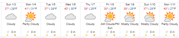
Once again, another overcast Monday. Overcast every single Monday this month. Going to be one of those weeks, especially with a long crappy New Year's weekend ahead.
-
00z Euro and GFS runs now want to give a little snow for parts of Ohio and Indiana with the latter also giving Freezing Rain accumulation, both right before another brief blowtorch again on New Year's Day.

00z Euro:
00z GFS:


-
Based on this tweet, the first half of January is 100% done.
-
 1
1
-
 1
1
-
-
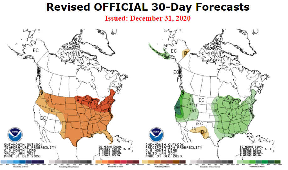
Looks like January thaw is about to be right on time. #SpringIsComing
-
6 minutes ago, zinski1990 said:
I call first dibs on 18z gfs lock
Sounds like a repeat of January 1999 since a bulk of the snowfall on today's 18z GFS run actually takes place around New Year's Day.
-
6 hours ago, A-L-E-K said:
idk man, kinda looking forward to Jan 1 when we get regular mode joe back
While talking about January 1st, today's 18z GFS run says "Party like it's 1999."

12z Euro on the other hand:


Shortly after 2021 begins:
-
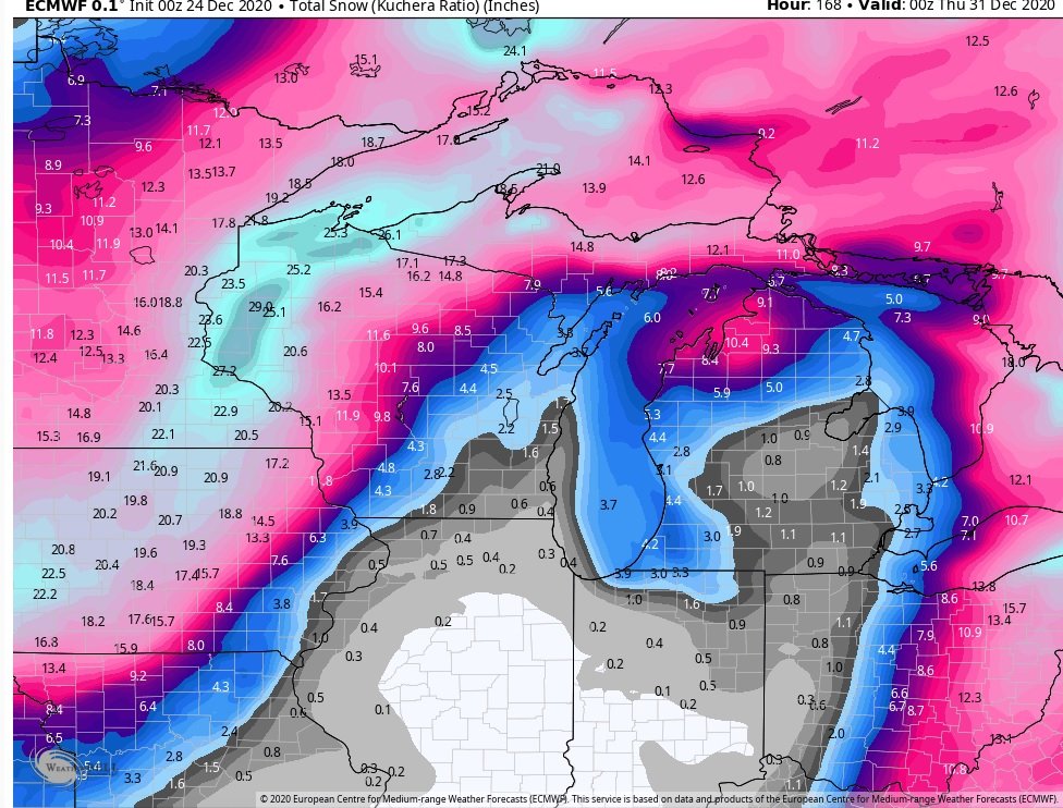
00z GFS (snowfall mainly following around the end of December):

00z Euro:

-
1 hour ago, cyclone77 said:
It's now been over a month (November 24th) since our heaviest snowfall so far (0.5"). Hopefully we can break the 1" threshold sometime in January.
Meanwhile, it will be a month as of next Wednesday since DAY's heaviest daily snowfall of the season (2.4") followed by its 2nd heaviest daily snowfall of the season (1.4") the day after.
-
1 hour ago, cyclone77 said:
New Euro follows seasonal trends. Iowa/Minnesota cash in while IL/IN twiddles their thumbs awaiting the next system.
While talking about tonight's 00z Euro run, though the rest of December is done:

In the meantime, the AO is supposed to go near neutral for a brief period before tanking again in a matter of days from now while the NAO goes slightly positive days from now before it tanks again.
-
1
-
-
On 12/19/2020 at 8:32 PM, Spartman said:
This thread should be renamed as the Christmas Eve 2020 Grinch Storm.
Turns out my thread name suggestion is appropriate.
-
1
-
-
Especially with the Grinch storm sweeping through tonight through the day tomorrow, it's definitely going to overcast for both Christmas Eve tomorrow and Christmas Day with the upcoming "Arctic" airmass. Definitely done with any chances for accumulating snowfall for the rest of this month.
-
1
-
-
The 18z run of the GFS is hinting at a blowtorch following the first weekend of January.
-
2
-
-
2 hours ago, mimillman said:
Lol not even arctic air behind it. What a joke.
March is going to average 41 degrees and be our snowiest month. Calling it now.
Wait until after we head into February still sitting with single-digit snowfall totals.
-
1
-

January 2021 General Discussion
in Lakes/Ohio Valley
Posted
Wonder what those NOAA forecasters think the suicide rates have been recently.