

dilly84
-
Posts
4,093 -
Joined
-
Last visited
Content Type
Profiles
Blogs
Forums
American Weather
Media Demo
Store
Gallery
Posts posted by dilly84
-
-
57 minutes ago, hawkeye_wx said:
00z Euro - The east trend continues. Central Iowa's snow is fading, but east-central is still good....for now. This run is also a bit south.

Good storm, but major difference from 12z and 18z wrt amounts.
-
2 hours ago, pondo1000 said:
That's brave haha
-
 1
1
-
-
1 minute ago, SchaumburgStormer said:
Pay, then click local
Got it. So pay side is hi-res. Never even realized they had a pay portion.
-
47 minutes ago, ILSNOW said:

How'd ya get that nice of a map on pivotal? Looks hi-res
-
32 minutes ago, vespasian70 said:
Going to end up with 7" or so here. A nice Christmas storm!
Something to cherish. Took me 37 years to see it. May never see it again. "Christmas Storm 2020". About the only thing 2020 has brought that's positive.
-
3
-
-
9 minutes ago, Gino27 said:
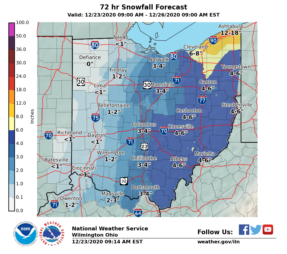
3” here north of plain city. It’s even still coming down. I can’t remember an overachiever like this in awhile.
Depends. The Canadian models nailed this one based on my totals. We may end up with 9" here.
-
7" in knox county with probably another 3 or so to come. Pretty unbelievable. First time in my 37 years to see this on Christmas Eve/Christmas
-
2
-
-
36 minutes ago, CoachLB said:
Yeah they did. Had me at 1-2 inches now a dab.
Then you were on the outside looking in as it was. Still has me at 9" in mount vernon. Don't buy it but if it moved it was by a hair.
-
1 hour ago, Gino27 said:
Didn't expect to see this given the latest model suite, but I'd gladly take this.
Rgem and Canadian only ones so far that didn't cave east. 3k NAM still isn't bad for a large section
-
3 minutes ago, chuckster2012 said:
00z Nam has Cincinnati at 6" ! Gfs has zilch. I'm afraid that GFS will be right..
Go look at Canadian. Has east central Oh getting a foot lol
-
3 minutes ago, Gino27 said:
Wheels fell off on the GFS. Could be the end for the west trend.
If you put your eggs in the gfs..
-
2
-
-
25 minutes ago, Gino27 said:
Probably going to be all east of me, maybe a coating. Just a slight tick west and I could see an inch or two. Eastern Ohio will do well again.
I'm in mount vernon. Looks like you'll see about what we will. Dusting to couple inches. Still holding out some hope, but its quickly dimished. If we arent seeing any changes on the 18z runs to signal something for 0z, id say its over for most West of Youngstown.
-
Never seen so much model agreement. Looking fairly clear now, for ohio crew, gonna be rain with a switch to snow for a brief period when the front passes. Will it be enough for a white Christmas, not sure. Barring changes within the next couple model runs I'd say dusting to 2" is looking to be the likely scenario.
-
1
-
-
2 hours ago, A-L-E-K said:
less map spam imo
I dont mind, I just wish they'd stop posting to the 25th then adding in one to the 30th lol
-
1
-
-
4 hours ago, hoosierwx said:
Hope buckeye is doing well and he starts posting again soon. Won't be winter without him. Dusting here and now 31 and rain. Maybe we pull off a Christmas miracle. Good luck to the Ohio crew.
Sent from my SAMSUNG-SM-G935A using Tapatalk
I talked to him, he's doing well. Said he took a hiatus, he still reads on occasion and will post again at some point. 8 days out Christmas storm now in the unphased mode on models, probably best this far out. Hope to see it back in play by the 20th.
-
2
-
-
3 hours ago, Aallen said:
Christmas Day is starting to look interesting!
Eve and day for sure. So far out yet, but been watching it for days now. Praying to the snow gods to give us a Christmas eve/day snow storm.
As for Buckeye, I think he left the board due to the covid thread it seems. He posted a rant there and has never posted again. Hopefully he comes around. One of my favorite posters here.
-
3
-
-
On 12/3/2020 at 1:46 PM, Steve said:
Very zzzzz for the next 10 days!!
Here's praying to the snow gods, to drop this about 50 miles south from the get go 9 days out lol.
-
20 minutes ago, Steve said:
Radar looks like crap.. still lightly raining!!!

Snowing here in mt vernon all day. Nothing sticking but moderate snow. Good for when the sun sets. We'll be ready to rock and roll wil instant accumulation.
-
1 hour ago, HighTechEE said:
First snow (storm) flakes of the season IMBY started about 8am this morning, radar looks like heavy snow down in Highland Co.
Snow here. Wasnt supposed to switch to snow til this evening.
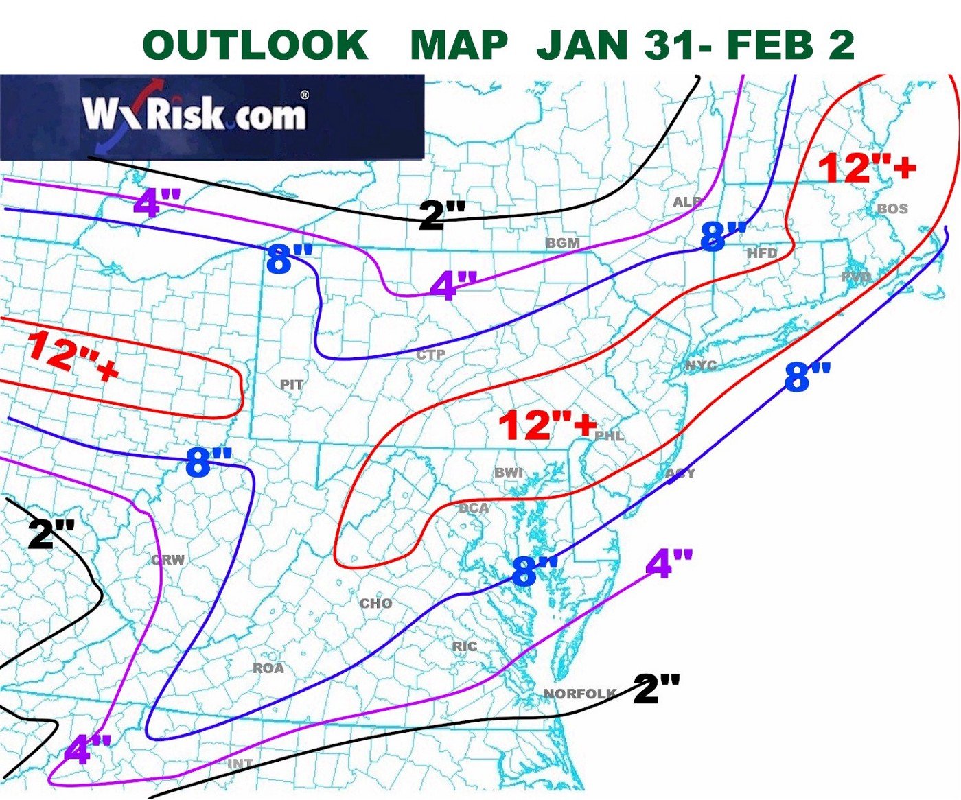

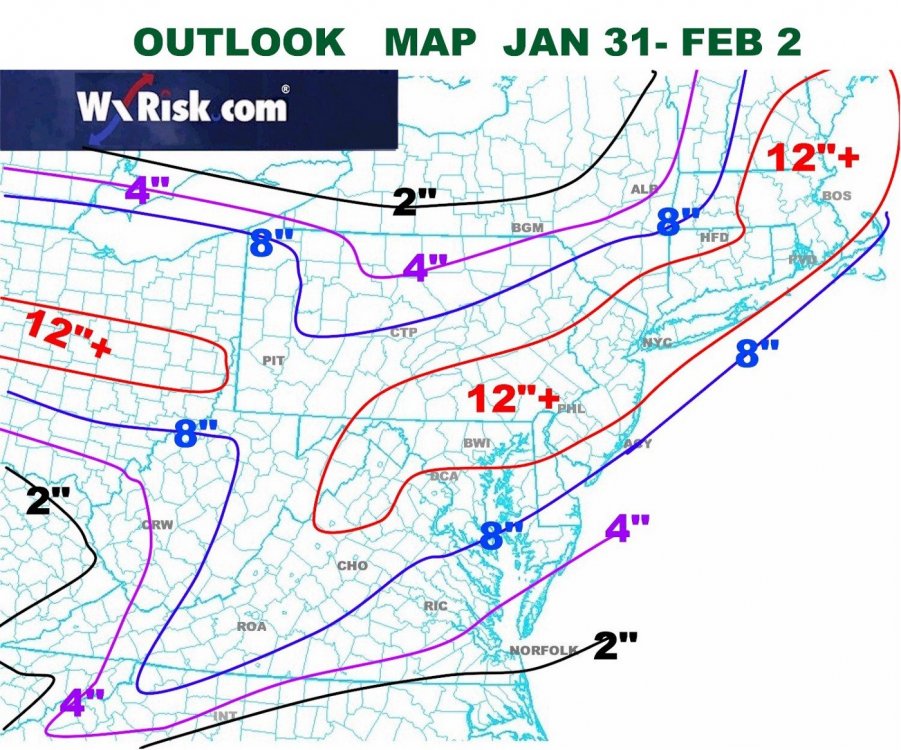
January 30-February 1 Winter Storm
in Lakes/Ohio Valley
Posted
UKIE and NAM are similar for my area, the GFS and GEM want to cut off the heavier stuff to western OH only. Guess we'll see which way EURO goes being the tiebreaker lol.