
The 4 Seasons
-
Posts
6,379 -
Joined
-
Last visited
Content Type
Profiles
Blogs
Forums
American Weather
Media Demo
Store
Gallery
Posts posted by The 4 Seasons
-
-
10 minutes ago, Go Kart Mozart said:
This is the normal NAM T-minus 36 hour scare. We feel hopeful until the rest of the models give us a hard no in an hour or two.
yeah i dont believe anything the nam is selling good or bad, the model is pure trash, just commenting on what its showing, well see what the globals do in the next couple hours
-
 1
1
-
-
The NAM/3K with a pretty sizable jump north for tomorrow night. Probably be a couple/few inches along 95 for CT.
-
3
-
-
1 hour ago, Damage In Tolland said:
Can we ban the term KU? How many KU’s have we had over the last years?
Quite a bit actually.
Some of these didn't affect SNE in a big way but even taking those out there's been 10-15 or so in the past 10 years that are Cat 1 or higher. Last one was probably Jan 28-29 2022.

-
1
-
-
On 2/9/2025 at 12:01 AM, ORH_wxman said:
Top 5 SNE snowstorm all time.
gotta be the best CT storm overall since 1888. i dont think anything really comes close
-
1
-
-
9 hours ago, RU848789 said:
Thanks, but why wouldn't you include Warren County on your maps? i get it's not part of the formal NYC MSA, but it part of the larger CMSA and just looks funny, geographically to be omitted, as it's closer to NYC than a bunch of the counties in the DMA. Just my $0.02.
https://en.wikipedia.org/wiki/New_York_metropolitan_area
Simple. It was the best looking/clean map of the tri-state area i could find on google that i was able to edit in photoshop. It looked just like that map that you linked from the wikipedia article, it had Pike county in there but i deleted it because it looked weird.
Also that link you sent literally has warren county ommited in the picture on that page LOL
"Map of the metropolitan divisions (MDs) of the New York metropolitan area and the additional counties that make up the New York-Newark, NY-NJ-CT-PA CSA, as defined by the U.S. Census Bureau in 2021[6]"

-
Im updating the season to date map today so if anyone has any reports from CT MA or RI let me know
-
1
-
-
3 minutes ago, iceman1 said:
i was hacked
-
11 hours ago, codfishsnowman said:
I remember well the morning of the Feb 01 storm. The radar just exploding off the NJ Coast. That was the last time I saw Thunder snow in an event.
Do you remember how big the flake size was at the start? It's one of the things i remember the most about that storm and read a lot of similar accounts. They were like baseball sized flakes for like the first hour (aggies sticking together). And then the CG thunder snow/sleet at sunset was unreal. A bolt struck my neighbors backyard and was incredibly loud, haven't seen anything that good. But have seen thundersnow a lot since then. Feb 03, Feb 13, Feb 17, Mar 18 also had thundersnow here.
-
1
-
-
I'll likely being doing an update to the season-to-date snowfall map so if anyone has an accurate total and wants to be included let me know, thanks. (please include your location)
-
3
-
 1
1
-
-
12 hours ago, Volcanic Winter said:
This is amazing, thanks very much!
I’m at about 4.5 inches on the season, Toms River but away from the water & well inland. We’ve been a bit of a snow hole this winter with storms missing both north and south.
is that on the map? probably just barely makes it toward the bottom there in Ocean right?
-
2
-
-
19 minutes ago, codfishsnowman said:
That was a cool event. It took awhile to get the better snow growth here but once it did we got 18 plus in 6 hours! We ended up with just a shade under two feet. The only bummer about 2/13 was that it happened at night
Yeah, 6"/hr and frequent CG lightning during the day would be something to behold. Closest thing i've seen during the day would be Feb 2001.
-
One of the best storms for CT in the past 10 years (other than Feb 1 2021). Lots of thunder snow and 2-3" daytime rates

-
1
-
-
-
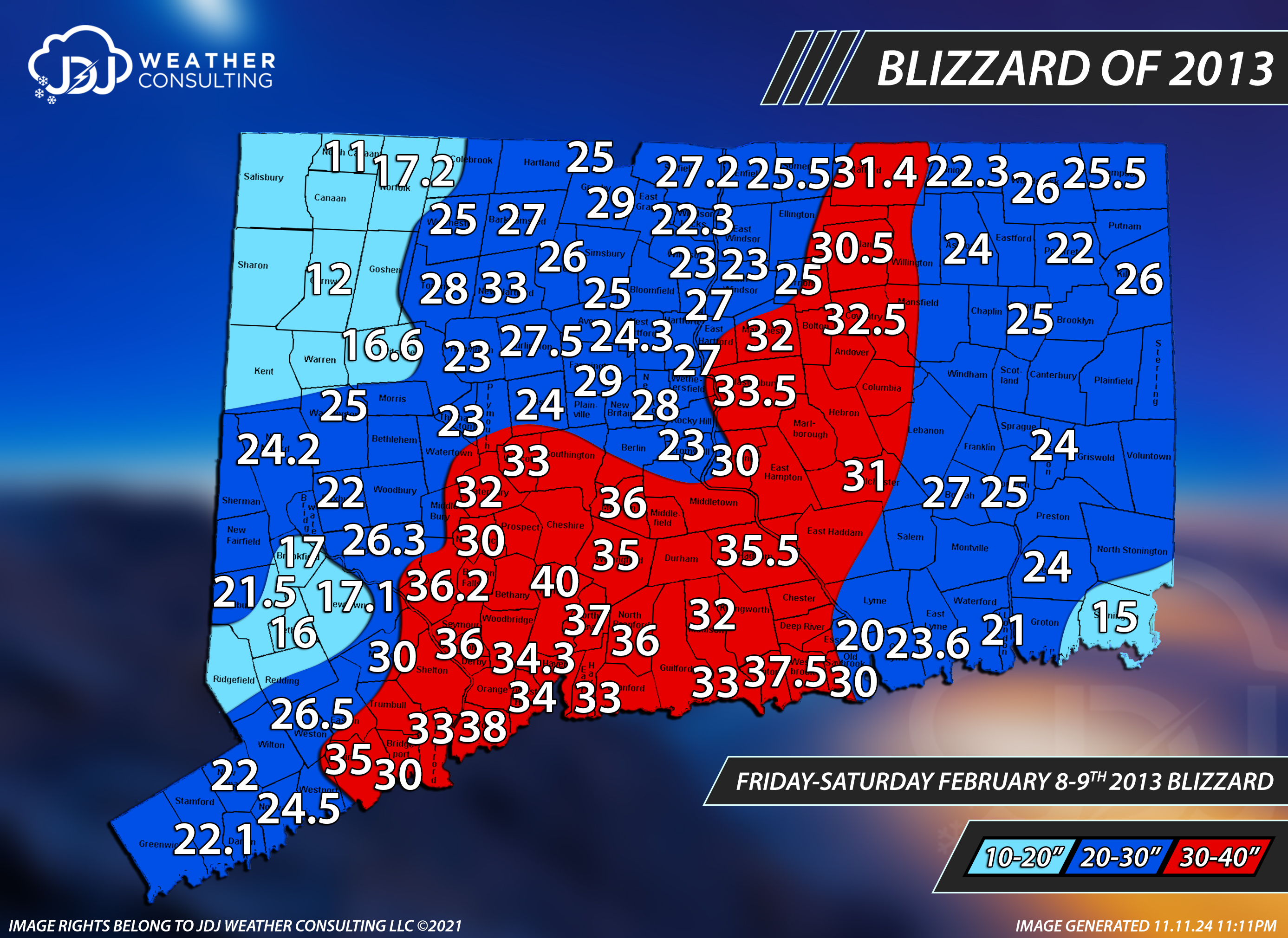
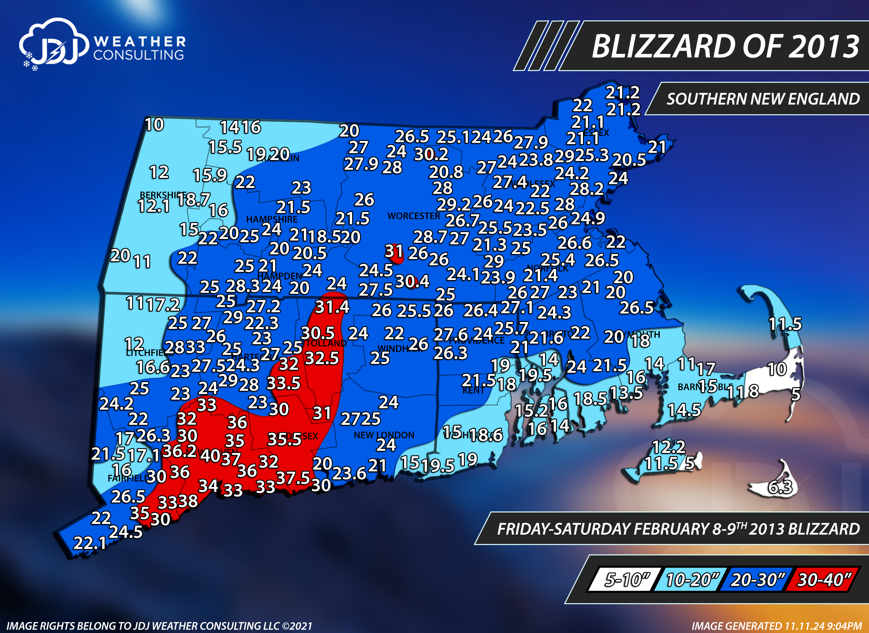
3 minutes ago, TheSnowman said:
28”. #4 For my Area in Recorded History, #2 of my lifetime. 2005 & 1997 is still my favorite of the 7 Major Full Area Blizzards though I must say (1992, 1996, 1997, 2003, 2005, 2013, 2015).
And I missed the Semi-major ones of 2011, February 2017, & March 2018.
only 40"
-
1
-
-
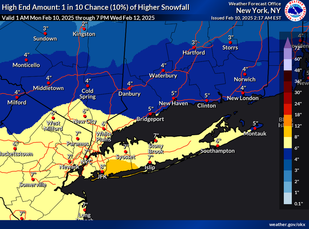
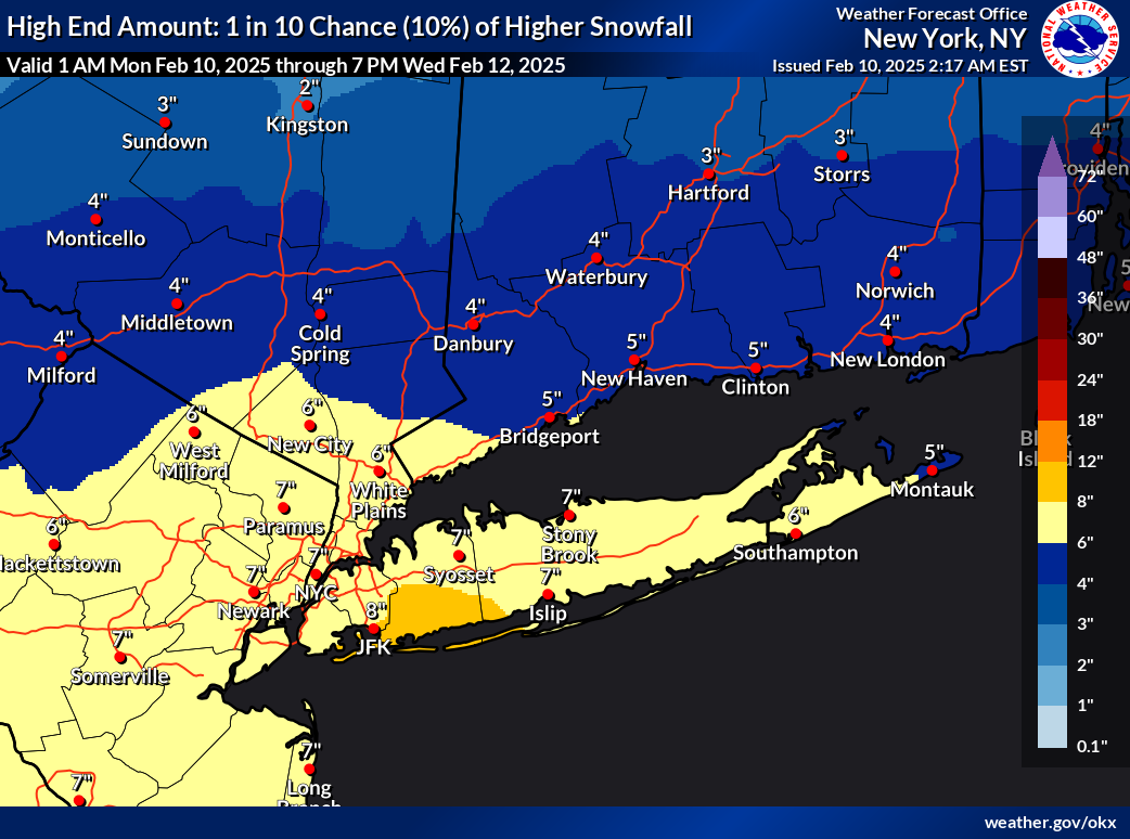
Even for a 1-10 chance this is a little ridiculous. Nothing shows that. Maybe half those numbers. Expected is reasonable
.thumb.png.49ef970e61ad6289a0870855faca005b.png)
-
1
-
-
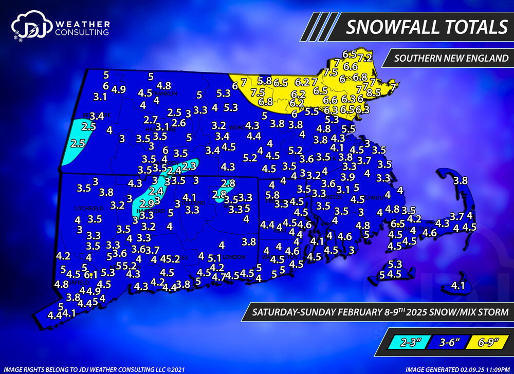
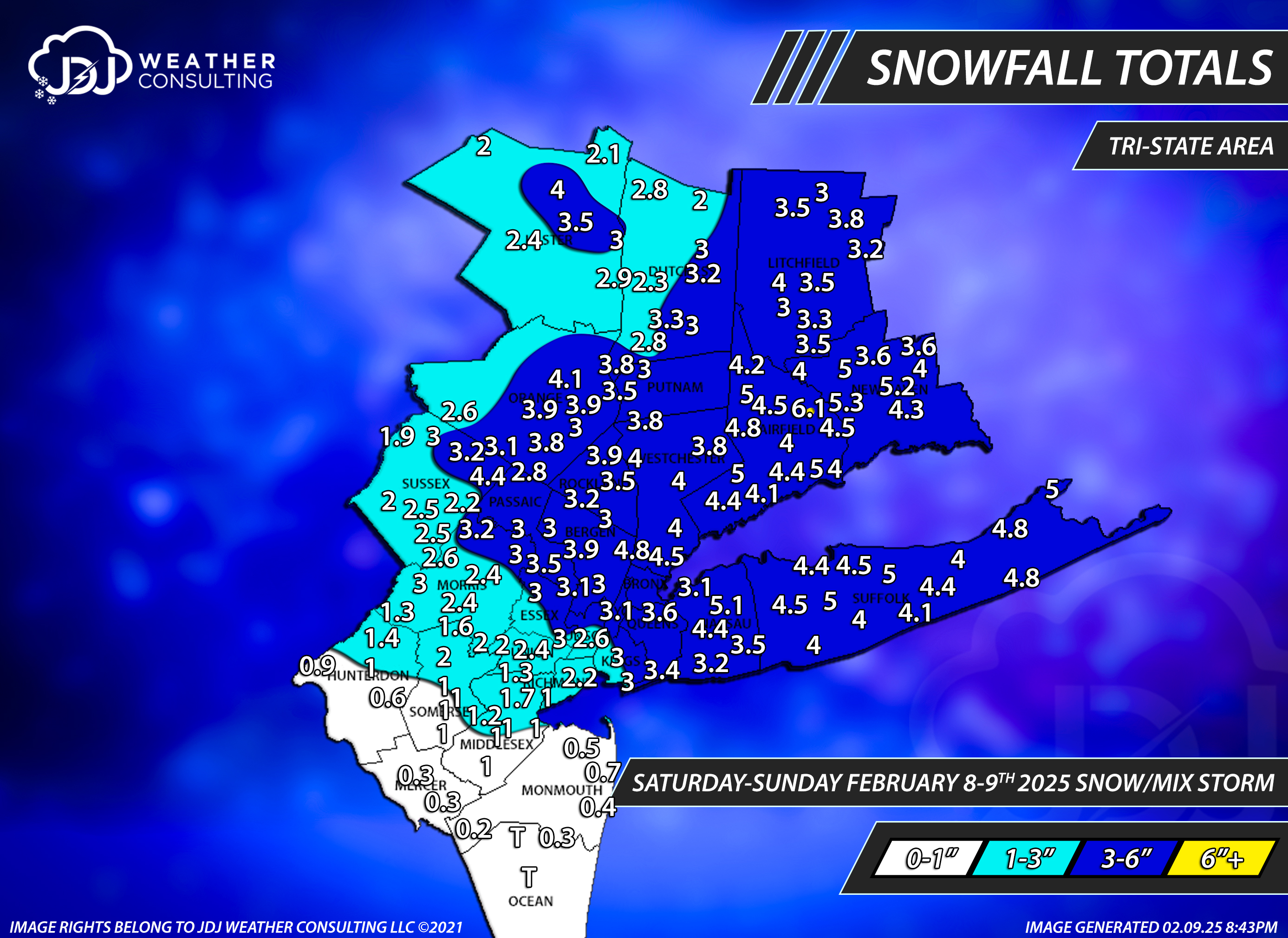
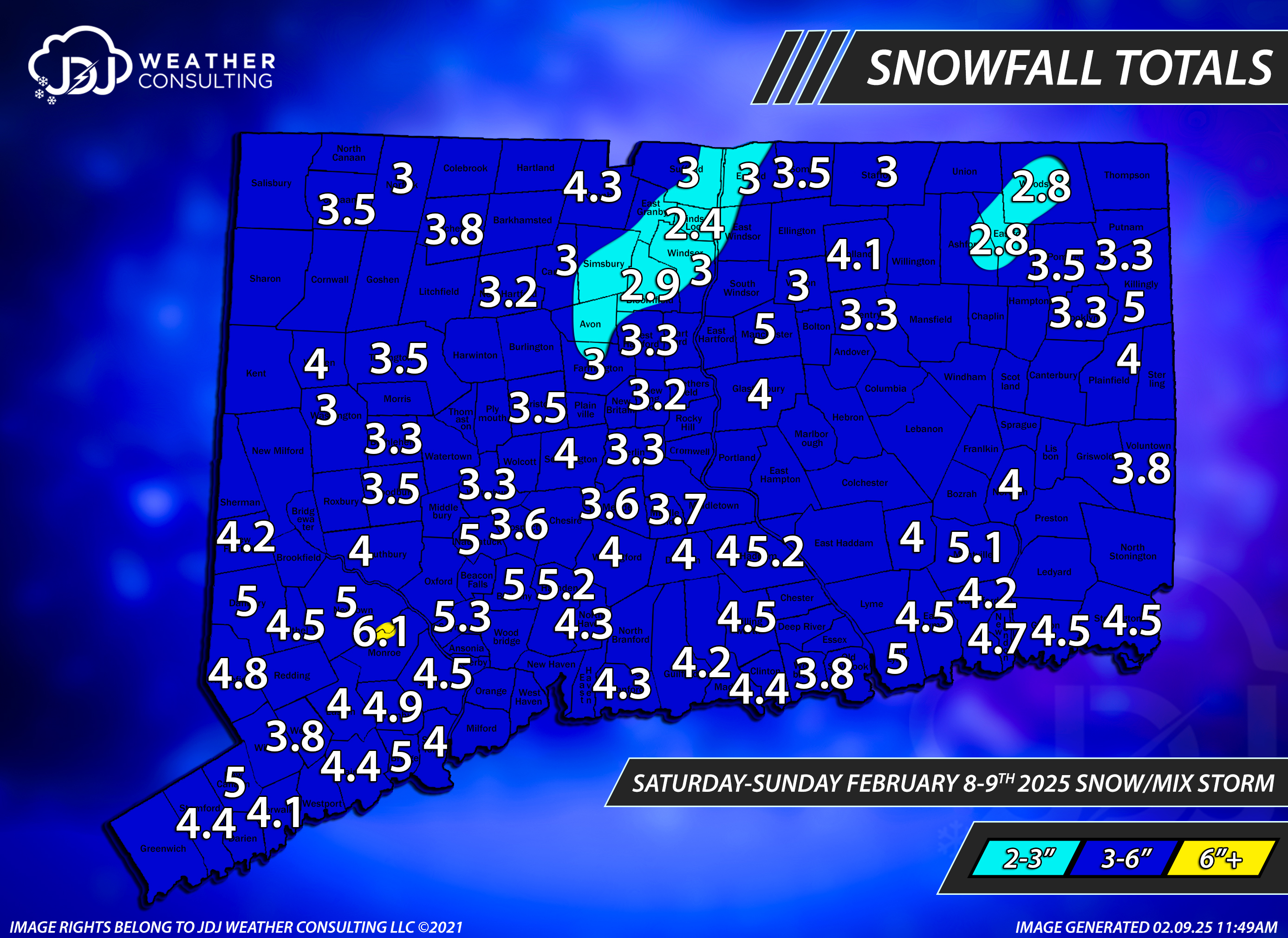
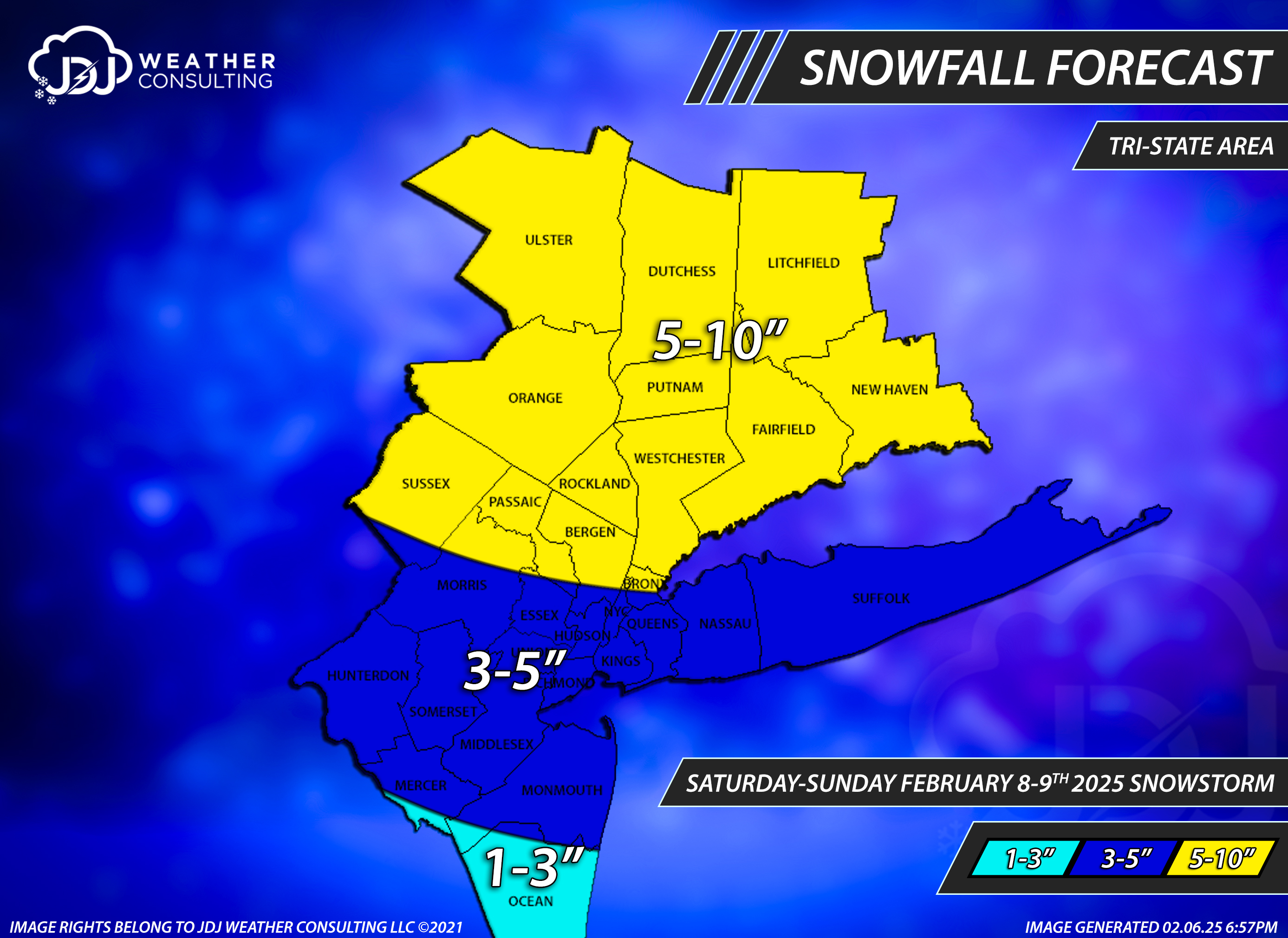
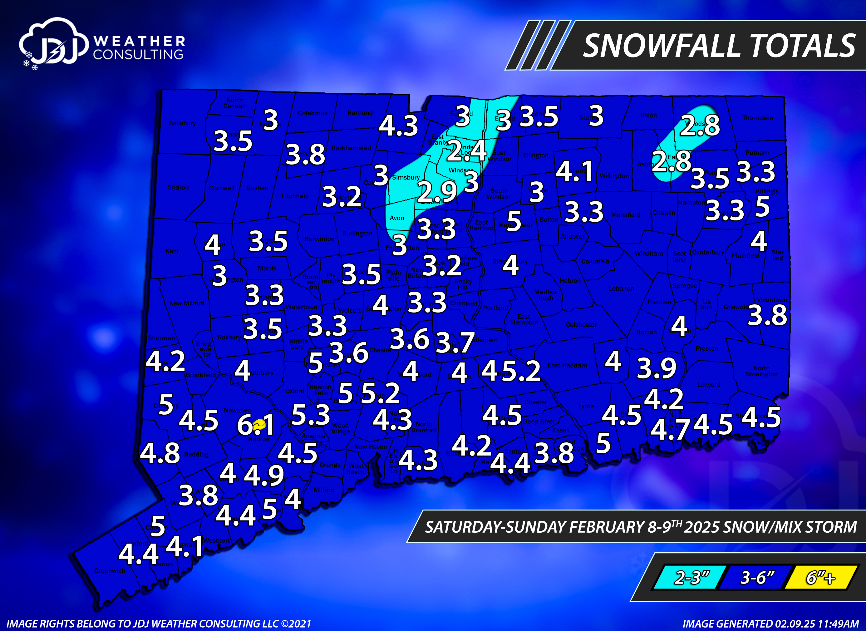
Updated for Feb 8-9th
-
1
-
-
Updated for Feb 8-9th
-
1
-
-
-
6 hours ago, Torch Tiger said:
went 5-8" here while NWS was 8-12". No one's mocking you btw
You are so dishonest and a gas lighter. So what was the purpose of asking "where's your 5-10 map" and then going to find it and post it underneath?
And the irony, your location verified.
6 hours ago, BombsAway1288 said:Yeah that was kinda low. No need to rub it in his face. It’s not like he went against the consensus and forecasted way too high, ridiculous numbers. Almost all other forecasts were similar and wrong.
He's defending me and himself. We are partners. TT is just trolling per usual and pretending like he's not.
-
 1
1
-
 1
1
-
-
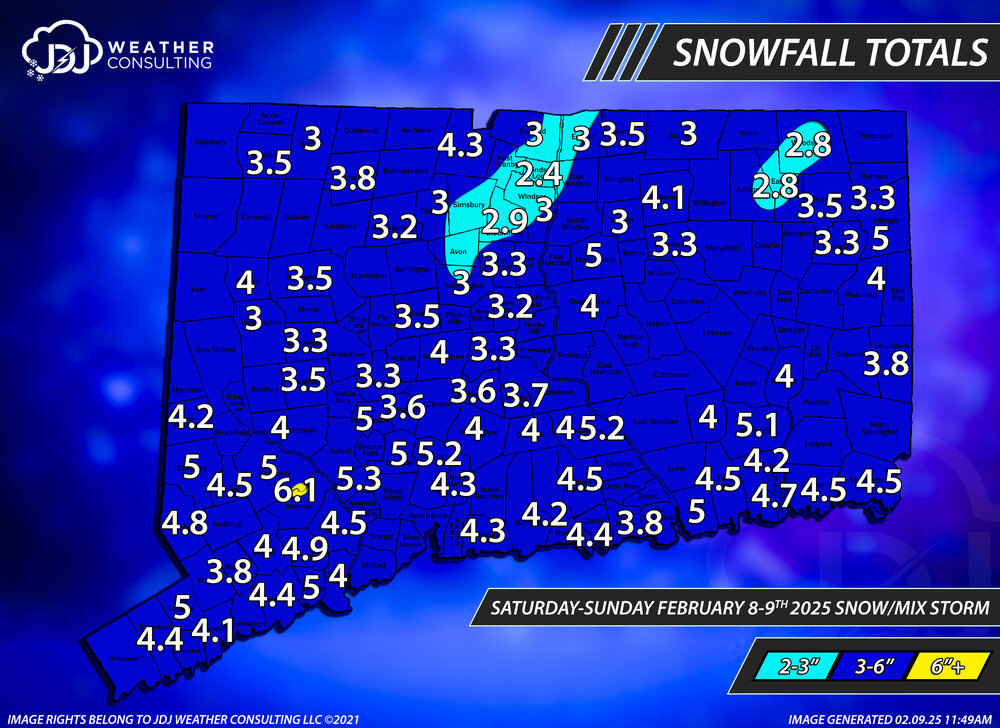
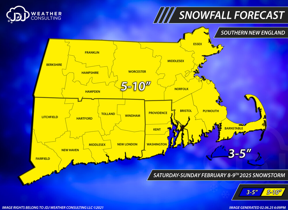
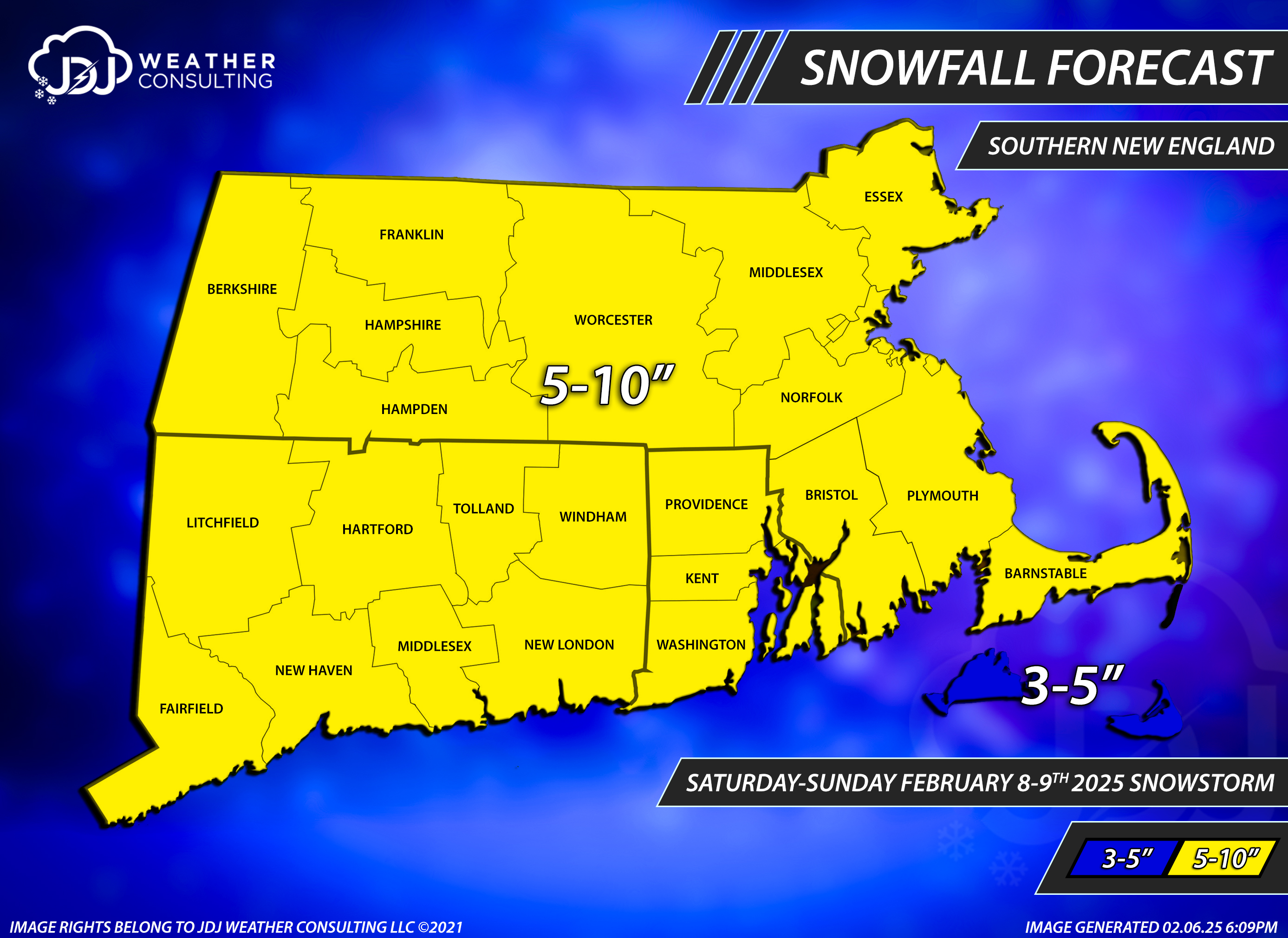
Snowfall totals for the 2-8/9 winter storm.
SNE was a couple inches lower than expected overall 3-6 vs 5-10 (except for N and NE mass). Certainly not the worst bust ever but not great either. Grade: D
Tri-state significantly better with the NYC/NJ/LI mostly verifying, CT and LHV too high. Grade: C-


-
1 minute ago, AstronomyEnjoyer said:
Here's Albany's map. Generated product though. Still hard to get an idea of snowfall totals.

id love to see this type of zoomed in version with numbers on the map for OKX and BOX, do those exist?
-
1
-
-
3 minutes ago, CT Valley Snowman said:
3 here. At least it looks pretty and the trees are somewhat caked with snow.
8 minutes ago, metagraphica said:4.0 Final here.
updated
-
1
-
-
4 minutes ago, Torch Tiger said:
where's your 5-10 forecast map?
I'm not done yet when i finish everything ill post it like i always do
-
pretty much 3-6" statewide. BDL 2.4 BDR 5.0. I'll have a SNE and Tri-State map done later today.

-
4
-


.png.4155f3c28b8d6745862c9a738ba5d333.png)


Feb 12/13 2025 Wintry Mix
in New England
Posted
RIP to any snow on the 18Z EC + 00Z NAMs