ILwxchr
-
Posts
97 -
Joined
-
Last visited
Content Type
Profiles
Blogs
Forums
American Weather
Media Demo
Store
Gallery
Everything posted by ILwxchr
-
Nov. 25th-26th Midwest Snowstorm Potential
ILwxchr replied to Malacka11's topic in Lakes/Ohio Valley
I'm facing the same dillema. I'm sitting south of Eldridge at my parents house and its pouring rain here. This band is just sitting here, but I also want to blast south back toward home and get into the deformation band later on with those 50+ mph winds lol. Ugh. I still think the cities sees a foot out of this but someone somewhere is going to pick up 15 inches imo. -
Nov. 25th-26th Midwest Snowstorm Potential
ILwxchr replied to Malacka11's topic in Lakes/Ohio Valley
Heavy rain here in the QCA. Sitting at 36 degrees. Should start cooling off soon, we have a pretty strong band that is E/W almost stationary. Hopefully we can get some dynamic cooling to switch over to snow by 11am or so, which is what the HRRR was indicating earlier. -
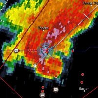
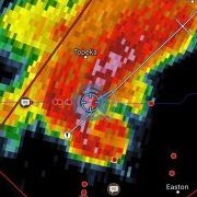
52 mph wind gust at Great Bend on the backside of the low with heavy snow in the vicinity. With the low strengthening later on we should see similar conditions across IA/MO/NE/IL.
-
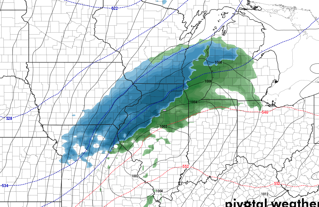
A majority of the thread on this event is over on Great Lakes/Ohio Valley. However we can't discount the western areas in the plains, 12-18" of snow is possible for Southeast Nebraska into Southwest Iowa with wind gusts of 45+ mph creating blizzard criteria conditions, which is already getting going with a heavy band sitting there. More meteorological details I have posted on the other thread.
-
Nov. 25th-26th Midwest Snowstorm Potential
ILwxchr replied to Malacka11's topic in Lakes/Ohio Valley
In the Quad Cities area for this event. My call for the cities is going to be 10-12"+ of snow with wind gusts possibly approaching 50 mph later tonight. I might have to drop south this evening if the HRRR is correct in showing 54 knot wind gusts (62 mph). IMBY I'm expecting around 7-9" with 50+ mph wind gusts. Totals won't make much of a difference though with that type of wind. I visited the NWS in Quad Cities this evening and they told me the criteria for blizzard warnings is very strict (which we know that), that call will be made later today once the storm starts to evolve toward the county warning area. Don't want to issue a high end product (Blizzard Warning is the most serious product they issue, per NWS), and have to revert to a lower product if it doesn't pan out. Public reception isn't very good when it comes to changing weather data. Although looking at the 06z data, its looking like it will be needed at some point (blizzard warnings). If this pans out, it will make my top 5 list for sure. Have fun everyone and be safe. -
Nov. 25th-26th Midwest Snowstorm Potential
ILwxchr replied to Malacka11's topic in Lakes/Ohio Valley
No Blizzard Warning on this package from DVN. I imagine they are waiting on more data and the possibility exists for that to occur overnight. Seems as though the heavy snow axis to me will be from about Mount Pleasant, Iowa to Princeton, IL to perhaps De Kalb/Aurora area, somewhere within 50 miles or so of that line. That would be my guess. As for my backyard right now, Galesburg, I'm expecting roughly 6-8 inches. If it shifts further south or if the HRRR, NAM, RGEM are correct, that could be too low of a forecast. But i've learned over the years to forecast low versus high lol. -
Nov. 25th-26th Midwest Snowstorm Potential
ILwxchr replied to Malacka11's topic in Lakes/Ohio Valley
DMX hoisting blizzard warnings. DVN should be next. -
Nov. 25th-26th Midwest Snowstorm Potential
ILwxchr replied to Malacka11's topic in Lakes/Ohio Valley
Follow the trend, don't take every model run to heart. -
Nov. 25th-26th Midwest Snowstorm Potential
ILwxchr replied to Malacka11's topic in Lakes/Ohio Valley
Blizzard Warnings going up in parts of SE Nebraska and Southwest Iowa. I'd expect that to continue eastward -
Nov. 25th-26th Midwest Snowstorm Potential
ILwxchr replied to Malacka11's topic in Lakes/Ohio Valley
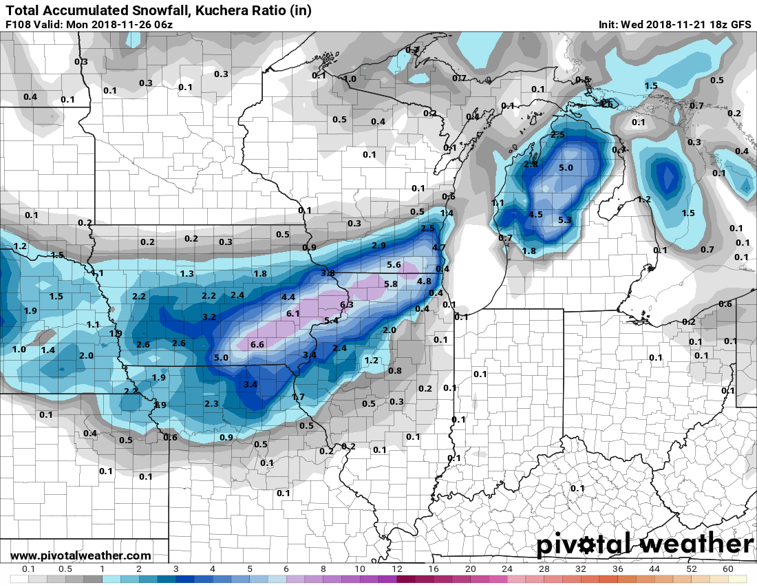
With the latest GFS caving southeast and the NAM/NAM3k showing similar totals, I'm thinking 5-8" of wind blown heavy wet snow for my backyard (Galesburg where I'm at now for the holidays). Quad Cities area I think will see the winner from this with a band of 8 to perhaps 10"+ from Southeast Iowa through the QCA up to Dekalb area. I wouldn't be surprised to see a foot or more in that band but the fast movement of this on the NAM has me concerned that we may not see it linger long enough for that high of a total. But again we have several models suggesting a band of those higher totals so I guess if we get several hours of 2" per hour rates, its not out of the cards. The HRRR 36 hour forecast shows winds out of the north at 10m over 40 knots here in Northwest IL. Wondering if DVN will pull the plug on a blizzard warning tomorrow at some point. -
Nov. 25th-26th Midwest Snowstorm Potential
ILwxchr replied to Malacka11's topic in Lakes/Ohio Valley
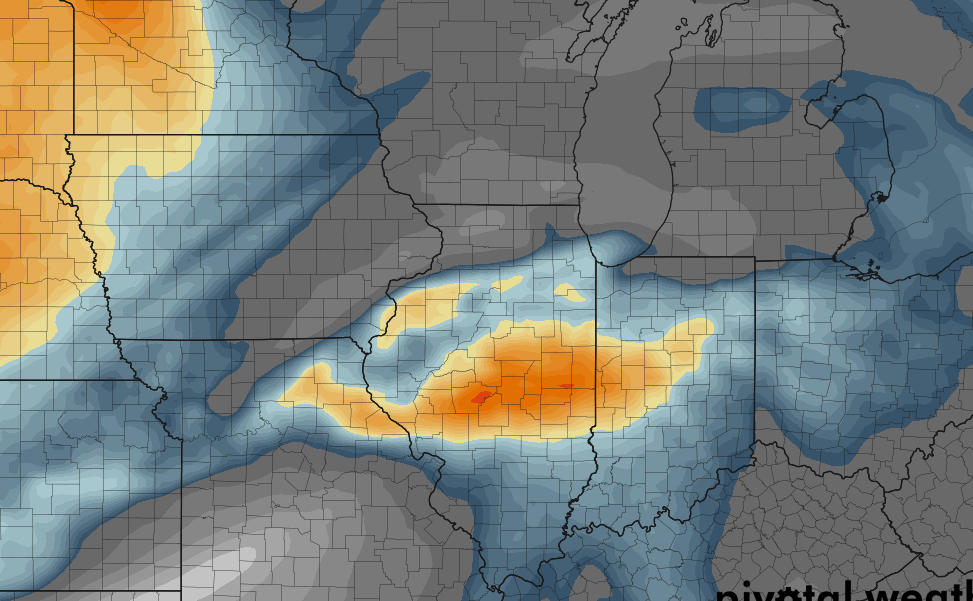
Lapse rates on the 18z NAM are pretty impressive along with the 700mb vertical velocities within the cold sector. I wouldn't be shocked to see some thundersnow as well within the heavy snow band. Looks like ILX and LOT both went with winter storm watches along with the rest of the DVN CWA too. All images valid at 18z Sunday Nov 25th via the 18z NAM today.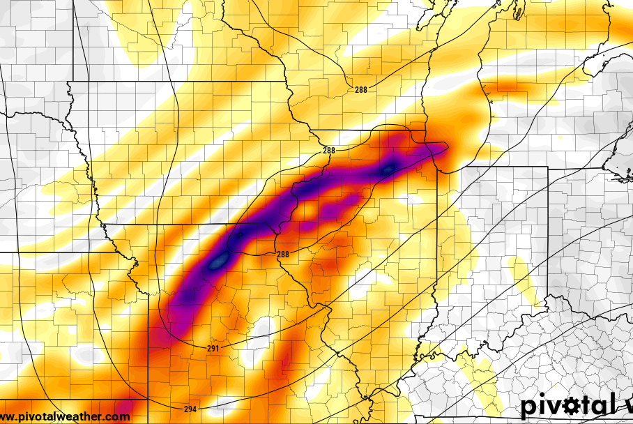

-
Nov. 25th-26th Midwest Snowstorm Potential
ILwxchr replied to Malacka11's topic in Lakes/Ohio Valley
Yep those are my exact thoughts on why we saw the northward shift. Much stronger mid-latitude cyclone and closed off mid level low versus a more flat wave. Reminding me of Dec 8-9, 2009 albeit quite a bit less intense. -
Nov. 25th-26th Midwest Snowstorm Potential
ILwxchr replied to Malacka11's topic in Lakes/Ohio Valley
Also the GFS hasn't been the most consistent model for the past few days either lol. My friends at KCRG in Cedar Rapids have been complaining about this making for a tough forecast. I don't blame them, with model inconsistency on the GFS its a huge boom or bust potential on their end. Take away the 12z GFS and its pretty clear about the southeast trend. Will have to see what the new Euro says and the 18z GFS. I wouldn't be too concerned yet. -
Nov. 25th-26th Midwest Snowstorm Potential
ILwxchr replied to Malacka11's topic in Lakes/Ohio Valley
12z GFS came back north while its 06z and 00z counterparts look like the 12z NAM along with the 00z Euro so I'm not sure what to think. My preliminary target is still going to be the Quad Cities area for video I think. I'm flexible about heading into Eastern Iowa or staying home in Western IL if the NAM is right. Either way someone is going to receive a serious early season dumping and probably some blizzard conditions. By only concern for the blizzard conditions would be how fast our temperatures fall and we get that drier snow versus the concrete. If most of the snow is heavy and wet that could limit blowing snow potential, but also hugely raises power outage potential with gusts of wind over 45 mph (perhaps even 50 as some models suggest). -
Happy Thanksgiving everyone!! Looks like a bit above average temperature day forecast imby. We could flirt with 50 this afternoon and typically we are in the low to mid 40s here. So I will be enjoying that before hopefully this weekends dumping.
-
Nov. 25th-26th Midwest Snowstorm Potential
ILwxchr replied to Malacka11's topic in Lakes/Ohio Valley
Euro going nuclear on Eastern Iowa. Hawkeye looks like ground zero there lol. I'll be north of Davenport near Eldridge so I'm hoping this can lock in lol. -
Nov. 25th-26th Midwest Snowstorm Potential
ILwxchr replied to Malacka11's topic in Lakes/Ohio Valley
00z GFS and 00z Canadian model are in pretty good agreement of a storm track. 00z Euro has wind gusts approaching 50 mph on the backside of this low, which given the extremely packed isobars on the GFS, I'm inclined to believe that will happen and then some....Someone is going to see the "b" word out of this if we see that scenario. I haven't seen a snow map for the 00z Euro yet, but I'm guessing its similar to the other models if Hawkeye is looking at a foot of snow.....going to be a fun next few days. I'll be in the QCA area until Tuesday morning, so this will be fun. Either I'll kill it or it will be an awesome time lol.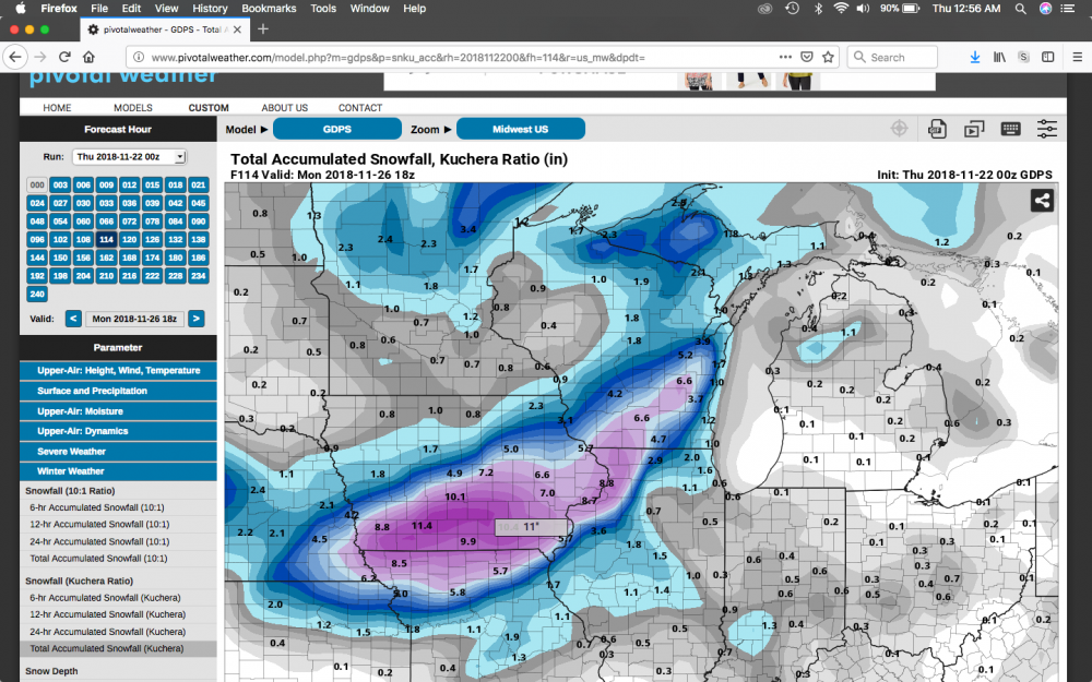
-
Winter 2018-19 Medium/Long Range Discussion
ILwxchr replied to snowlover2's topic in Lakes/Ohio Valley
18z GFS similar to the euro although a bit further southeast. Looking like Eastern Iowa on both models is the hot spot for snowfall. Although the GFS is a lot weaker with the system. Only 999mb in Missouri opposed to last nights 988mb run.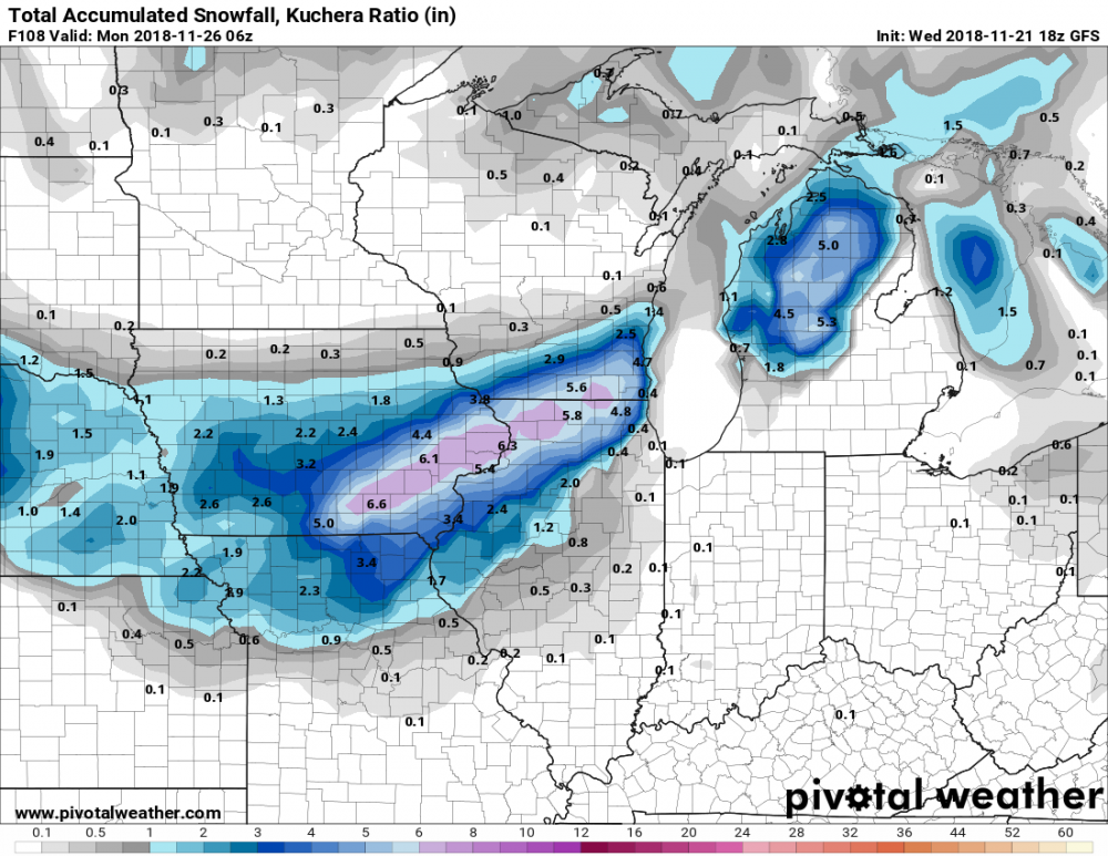
-
Winter 2018-19 Medium/Long Range Discussion
ILwxchr replied to snowlover2's topic in Lakes/Ohio Valley
I have more of a Dec 19-20, 2012 vibe versus a Dec 8-9, 2009. The 2009 cyclone was pretty intense, it got down into the 970s I believe as it moved into Michigan (my avatar). Even the 2012 cyclone was about 984mb near Chicago. Both storms produced widespread blizzard conditions but the 2012 system had a secondary deformation zone that extended down into Western and Central IL that produced blizzard conditions and 60+ mph winds. Based on last night's runs looking at the pressure gradient on the backside of this low, I was concerned somewhat about that scenario. Its too far out to say though I think at this point, even that was a very last minute change (within 8-12 hours we went from advisory to blizzard warning). -
Winter 2018-19 Medium/Long Range Discussion
ILwxchr replied to snowlover2's topic in Lakes/Ohio Valley
If the FV3 is right, you'll be in prime position up there in Erie. Lock it in. I know its a week out, but still fun to look at -
Winter 2018-19 Medium/Long Range Discussion
ILwxchr replied to snowlover2's topic in Lakes/Ohio Valley
The wind component on this has me concerned for some possible blizzard conditions somewhere. GFS was showing northerly winds of almost 30 knots. I was looking at weather.us and it was showing average surface gusts of 50 knots over Eastern Iowa. If that verifies with even 6 inches of snow, that could be big trouble. I remember on December 20, 2012 we had about 5 inches of snow in Galesburg, IL and one of the sensors clocked a 65 mph gust and it was an absolute mess with wrecks. I was in Wisconsin (unrelated).....I still got around 15 inches up there. I'm really rooting for this one to shift a little more southeast so I can get in on some backyard action. But I also have a place north of Davenport, Iowa so I can always go up there and document it too. Fun storm to track for so early in the season as Cyclone said! -
Winter 2018-19 Medium/Long Range Discussion
ILwxchr replied to snowlover2's topic in Lakes/Ohio Valley
Anyone else notice the low is pretty vertically stacked on the GFS and even shows some slight weakening as it moves eastward into the Ohio Valley? I haven't researched this much, but in my experience a slightly weaker cyclone could yield a further southern (right deviation) track? -
Winter 2018-19 Medium/Long Range Discussion
ILwxchr replied to snowlover2's topic in Lakes/Ohio Valley
12z Euro showing a 996mb low developing in the Southern Plains and moving from Southeast Missouri into Michigan on Tuesday into Wednesday morning. Could be interesting to watch. GFS has a much weaker version of this.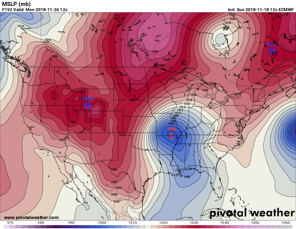
-
Winter 2018-19 Medium/Long Range Discussion
ILwxchr replied to snowlover2's topic in Lakes/Ohio Valley
I was watching this on last night's 00z run. Hopefully it doesn't pass us as a weak shortwave and then phase into another east coast bomb. . -
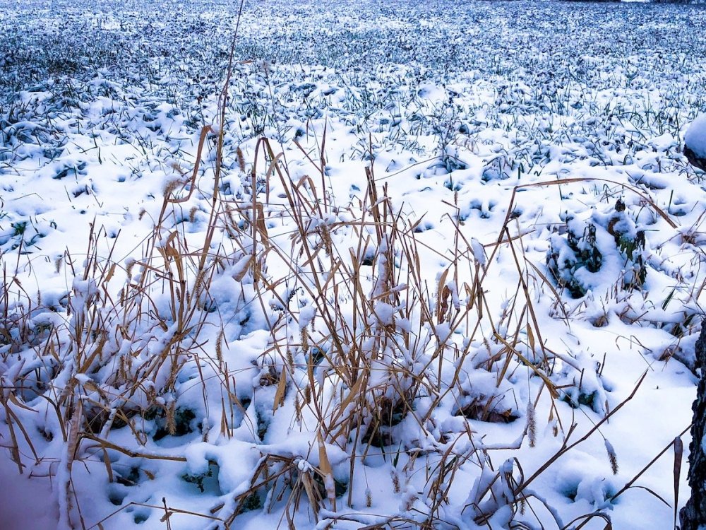
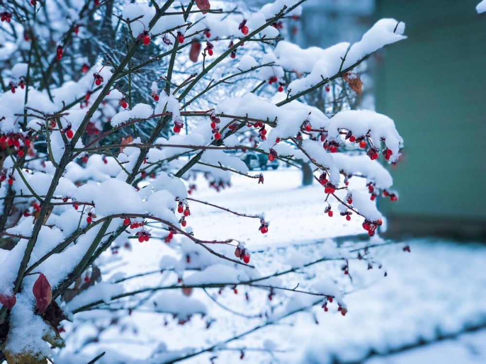
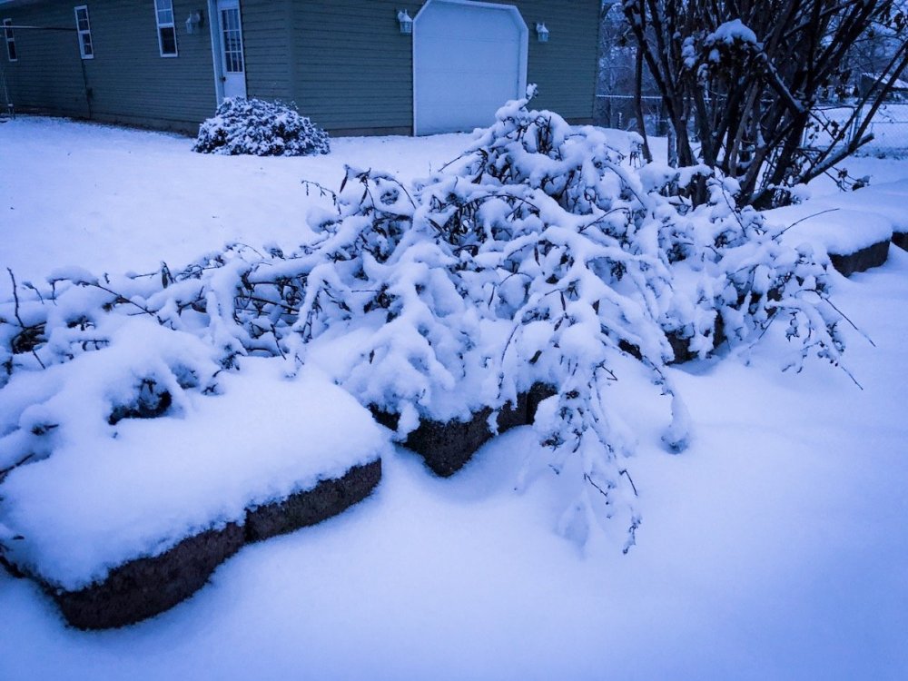
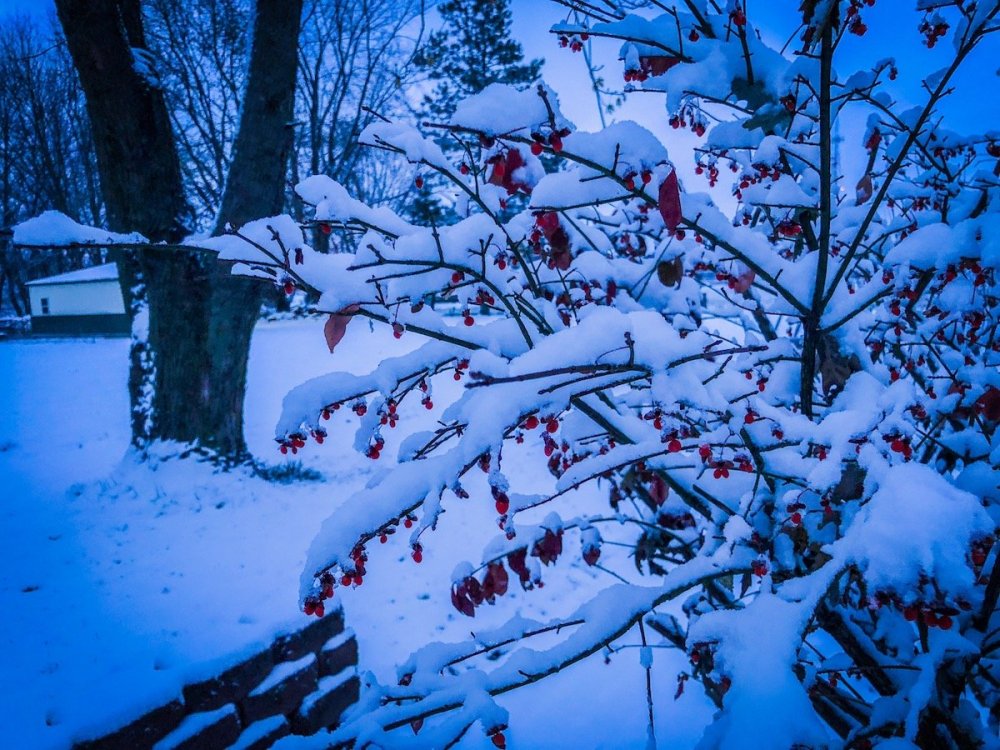
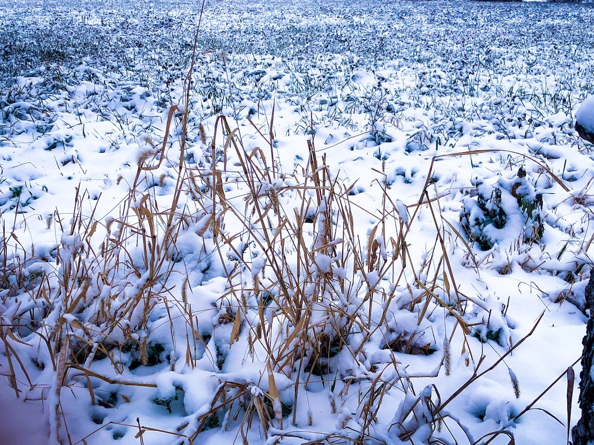
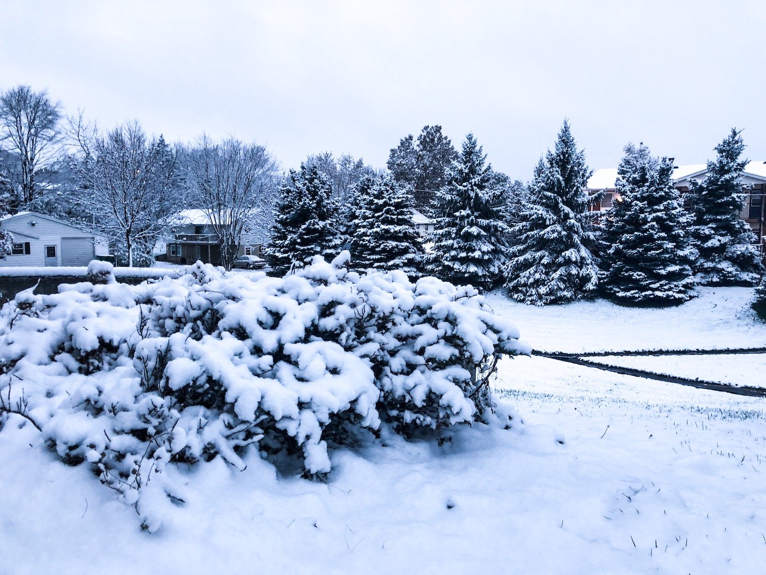
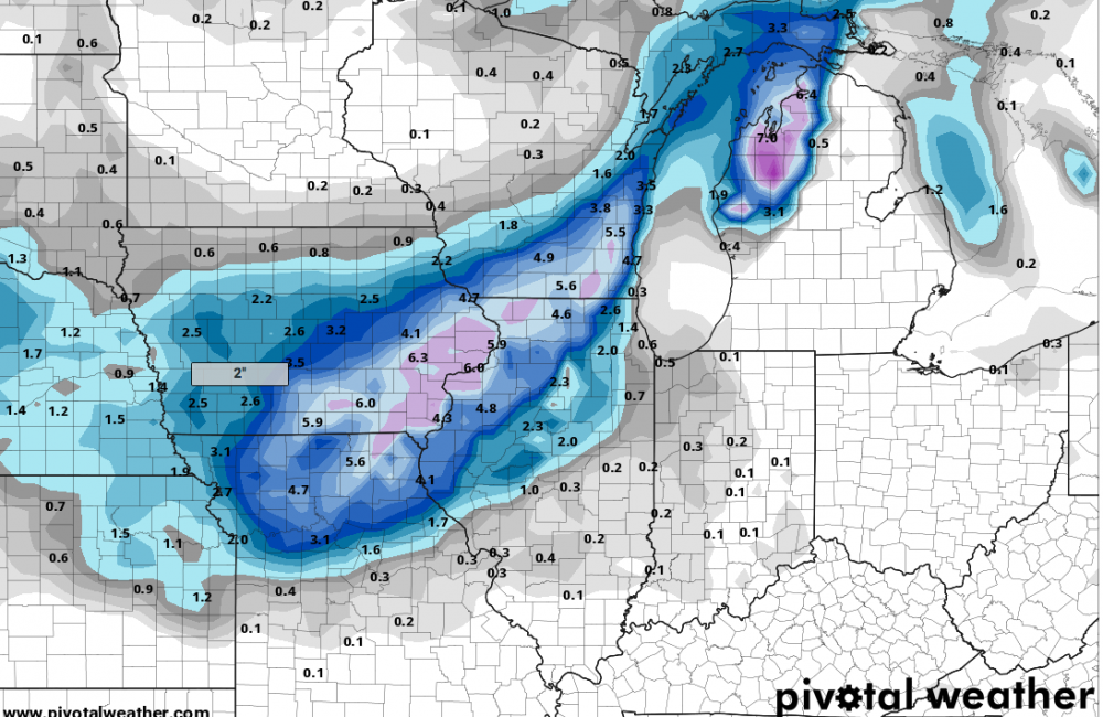
Picked up around 2.3" of snow this morning in Western Illinois south of Galesburg. Another decent early season snowfall (decent for November standards). I'm not complaining. Here are some photography that I shot this morning. A few areas to my north in Mercer County (New Windsor) got close to 4-5" from what I saw, kinda jealous of that lol. Especially after missing last week's 7" snowfall by 45-50 miles. But I take what I can get.