geddyweather
-
Posts
768 -
Joined
-
Last visited
Content Type
Profiles
Blogs
Forums
American Weather
Media Demo
Store
Gallery
Everything posted by geddyweather
-
This complex is just incredible in terms of impacts. Along with your standard convective element, you've got High Wind Warnings for the trailing meso-low, and now: Lakeshore Flood Warning posted via GRR due to an increased risk of seiche/meteotsunami along the Van Buren County shoreline of Lake MI.
-
Quick mesoanalysis check: MUCAPE ballooning over 5000j/kg in IL with big time mid-level lapse rates, topping out at 8.5C/km in the area of Chicago metro. Maybe one of the best MCS environments we have been presented with all year?
-
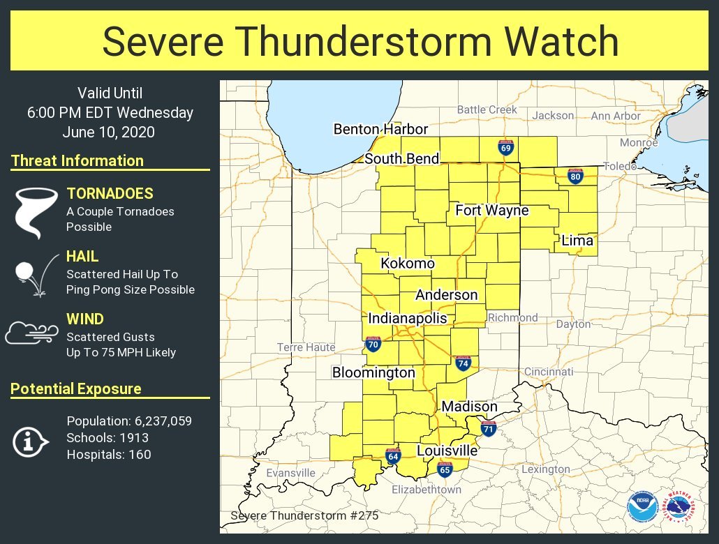
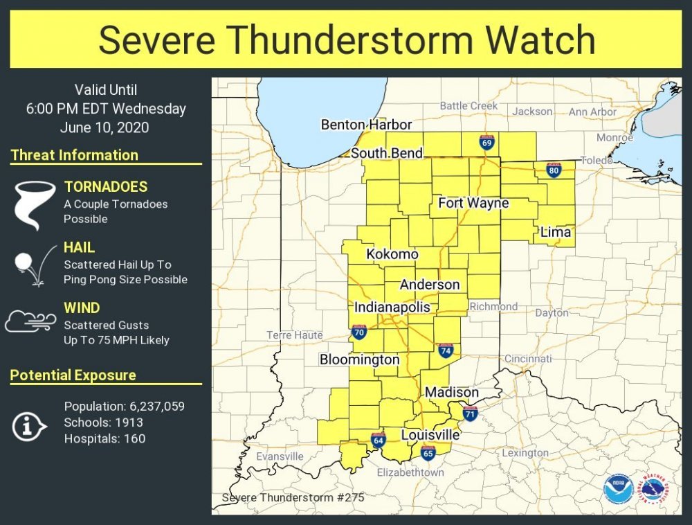
Not much change with the 1630z D1. 30% hatched wind got extended south to between Cincy and Dayton. Lots of development underway in Central Indiana.
-
-
Indeed. The HRRR seems like it has had that tendency all year, with mixed results. Wind profiles seem rather uni-directional but there is some backing near the surface, so I'm wondering if maybe a hybrid of the two (think QLCS type event) may end up being what we see? It'll be interesting, for sure. 85/76 here in Columbus Grove (north of Lima, OH), southwesterlies have been rolling all morning. SPC just hoisted an MD for IN/OH with 95% chance of a SVR watch being hoisted.
-
Surprised there isn't more chatter about tomorrow, though it "technically" isn't associated with the Cristobal remnants. Eastern IN/western OH (especially between I-69 and I-75 give or take some miles) seems like it has a decent shot at a TOR or two before things go linear. Winds aren't as backed on soundings as I'd like to see personally, but lots of other ingredients (good CAPE, lapse rates, decent low level SRH) are present. Definitely think it is worth monitoring.
-
I forgot to even touch on that lol. But definitely need *something* out that way. I was prepared to see some expansion of the risk area, but what they did was not what I (or really anyone apparently) had in mind.
-
That D2 outlook is one of the goofier updates I've seen lately. Went from localized in the OH Valley to almost 5 whole states completely covered in SLGT including basically all of the lower/mid Appalachians...
-
Unbelievable. I hadn't heard anything from there today yet and had the slightest bit of optimism things had leveled off. Just horrific. Anyone who thinks this whole thing is BS should be made to watch what is happening in Italy.
-
"Public Information Statement National Weather Service Nashville TN 420 PM CST Wed Mar 4 2020 ...Update on Davidson/Wilson/Smith County Tornado... NWS survey teams have concluded that one long-track tornado occurred in Davidson, Wilson, and Smith Counties on Tuesday morning. The path of this tornado stretched roughly 50.25 miles from beginning to end, starting in the John C Tune area and ending 3.50 miles west of Gordonsville. Survey teams are continuing to work on where this tornado began near the John C Tune area. The final tornado path remains subject to revision as teams complete their survey." No word on Putnam County/Cookeville area. Believe there are still 17-20 MIA so that may be why surveys have not progressed there.
-
Wrap around stuff for NWO is probably the last hope for a white Christmas in the area. Thinking maybe 0.5-1" at most, if we're lucky. Wind will be interesting Christmas Eve...