Snowman.
-
Posts
928 -
Joined
-
Last visited
Content Type
Profiles
Blogs
Forums
American Weather
Media Demo
Store
Gallery
Everything posted by Snowman.
-

January 24-26: Miracle or Mirage JV/Banter Thread!
Snowman. replied to SnowenOutThere's topic in Mid Atlantic
Capital Weather Gang and their clown boom and bust snow maps make me sick. -
The Euro’s pretty much locked in just gonna be small ticks here and there.
-
Looks like the most logical model output based on our climo.
-
I’ll take a QPF bomb even if that comes with a changeover to sleet.
-
DCA and BWI jack on ICON
-
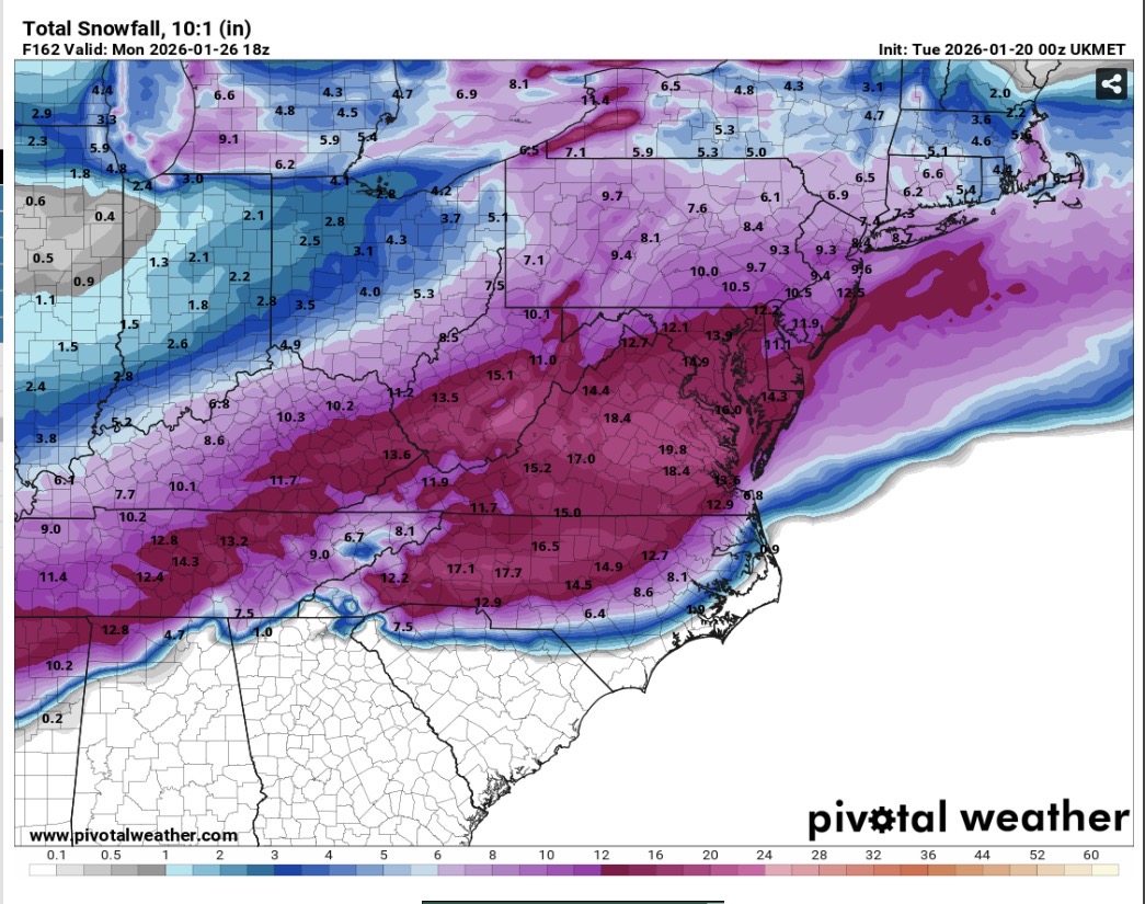
Pivotal finally updated the UKMet snow map
-
UKmet looks ready to clobber us.
-
Any snow map?
-
-
This one isn’t meant for us in Loudoun. Rooting for y’all in the 95 corridor.
-
Flurries in Sterling
-
Well if the UKMET is correct then DT's map will literally not verify at all for richmond. Looks like a complete miss for them.
-
he's such a weenie
-
If there's one model that I can trust to score a coup its the Euro. Not saying it's gonna happen, but you never know.
-
Man the Euro is always stubborn.
-
I'll take a foot of cold powder any day
-
UKMET is a amped bomb
-
The king has got his subjects bending the knee.
-
The GFS really is just a terrible model
-
Wow the Euro is locked in right now
-
That was a yellow card Ralph
-
CMC is about to explode
-
We will see. Seeing the EPS look like that with an 8” mean is also very promising. Always feels good to have the highest rated model and its ensembles in your corner.
-
Jan 2016 the models were all generally locked in to a major snowstorm close to a week out. Right now every major model besides the dogshit GFS has the general area with us near or at least a foot so i’m pretty optimistic.
-
60-70% chance of 6” five days out is crazy