
WhiteoutWX
-
Posts
892 -
Joined
-
Last visited
Content Type
Profiles
Blogs
Forums
American Weather
Media Demo
Store
Gallery
Posts posted by WhiteoutWX
-
-
Repost from central forum:
I'll be targeting Nebraska. My current thinking is chances for rain/clouds seem higher in eastern and southeastern parts of the state which is unfortunately where I was initially targeting (the closest drive from Oklahoma). I was hoping to stay south of I-80 but if morning clouds/rain look to be a problem I may target as far N/W as Grand Island. I have no reservations so if it looks really bad in Nebraska Sunday night/early Monday I may just bail altogether. I'm not going to deal with traffic nightmare/longer drive if I would have to go through KC area or further east.
-
Thanks for putting that together, Quincy. It really is amazing how few tornados there have been in the southern Plains this year. And like you said, it would be hard to draw up a much worse pattern for the first 10-15 days of May. There is always the end of May when good things can happen with less than stellar troughs but I have to admit my optimism has really trailed off the past few weeks.
-
So who else is excited for the omega death block of doom the next 7-10+ days? Fun times.
-
 1
1
-
-
1 hour ago, CGChaser said:
12z euro has the wf farther north Friday afternoon. Definite shift north w/ regards to track as well. low placement on 00z run near little rock @06z saturday, 12z run has low ~Tulsa.
Looking at 500 mb the 12z Euro and GFS are almost identical at 96 HR. The Euro is maybe a bit further north than the GFS but very close.
-
GFS and Euro continue to have large differences in trough placement/orientation for this Friday which has a large impact on surface low and frontal features. SPC has southern half of OK and north Texas outlooked but mentions the model uncertainty. Which model caves first?
-
28 minutes ago, bjc0303 said:
Operational runs don't offer much of a clue as to whether it's going to be active or not. Operational GFS could never show those troughs again.
What should be a welcome sight, however, is this:

This lends credence to the GFS, and the GEFS/EPS seem to be in very good agreement on that period being particularly active. Also fits the recurring pattern of active end of month into early month. GWO/AAM forecasts also indicate increased svr potential in that time frame. Do we get a bigly stretch? Tough to say obviously, but keep in mind that an active period in late April into early May can prove bad, given favorable interactions of the still-active jet with dewpoints beginning to commonly approach upper 60s and low 70s...
I've been following the GFS AAM forecasts the past few weeks. It's consistently been showing a move towards Phase 1/2 space in longer ranges but so far that has yet to materialize. It is encouraging to see the GEFS/EPS in agreement for the time frame you mentioned though. Maybe this time the threat will have legs.
-
1
-
-
7 minutes ago, jojo762 said:
I was shocked honestly given the degree of model spread in location/timing. But outlook area can/will be adjusted as we progress.
GFS says Wednesday may have some potential as well. It is further south than the Euro though for the entirety of the middle to end of next week.
-
Definitely nothing that screams outbreak in the next 7-10 days, but the GFS is at least offering some possible smaller scale setups in the southern Plains in that timeframe. Looks like Saturday, Monday, Tuesday, and Wednesday all have at least some potential in the TX-OK-KS corridor. Upper flow is lacking, especially Saturday and Monday, but there may be *just* enough mid level flow coupled with good moisture and low level shear for at least a conditional tornado risk any one of those days. One other caveat is capping may be a concern with no clearly defined waves at the moment to help provide background ascent, but maybe some subtle shortwaves will appear that could help with that as we get closer.
-
1 minute ago, bjc0303 said:
Not really, they are pretty similar last I saw. However, capping looks to be an issue farther south. That's not to say CI won't happen.. The GFS was forecasting CI and so has the ECMWF. Given how far out it is they will likely expand in later outlooks, but better (or should I say more likely to be focused) large-scale ascent will be farther northeast. I'd expect it to expand in subsequent outlooks.
Fair enough, that makes sense. Definitely has my interest piqued. Could be the first big plains setup this year, as you stated previously.
-
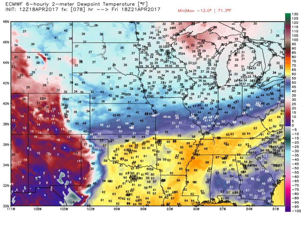
Really confused as to why the SPC outlook for Sunday only extends as far south as Kansas. 12z GFS has some very impressive parameters (minus some S-shaped hodos) all the way south through Oklahoma and into north Texas, with several PDS TOR soundings throughout that corridor. Obviously it's a ways out and could change but given the current data the placement of the risk area seems odd to me. I haven't seen the Euro is it completely different?
-
6 minutes ago, brettjrob said:
The 500 mb pattern progged over the next two weeks right now is nothing short of insane, especially by the standard of recent years. Nonstop intense shortwaves dropping into the Rockies and carving across the central CONUS, one after another, with no end in sight. It's been at least since 2011 since we saw a similar pattern in the springtime, and maybe 2008 for the Plains. Really, the first half of May 2003 is what comes to mind, looking at this morning's GFS. It's just happening 30-45 days too early to take full advantage with these short wavelengths, from a severe perspective. But we'll probably get our first headline-making tornado event of the year (outside the Gulf coast) out of this period somehow, regardless.
It seems like maybe too many short waves for this time of year? Not enough time for moisture recovery? Agreed that you have to think this upcoming pattern has to produce SOMEWHERE...it's just a question of how far north and west the threat can make it.
-
GFS has taken many steps backward for Sunday as far as moisture quality into Oklahoma is concerned, mainly due to a stronger frontal push with the Friday system. I'm now convinced any tornado threat stays along and south of Red River, with maybe the exception of far SE Oklahoma into SW Arkansas.
And the broad SW flow aloft it was showing a few days ago for early to middle next week has quickly morphed into one much stronger, slower trough that doesn't look to eject until mid to late next week. Euro may offer slightly more hope, but probably still too far out to speculate what potential that one has though.
Overall rather disappointing changes for any Oklahoma locals, but hey it's only March. Probably to be expected!
-
1 hour ago, bjc0303 said:
Moisture return looked late. also 00z GFS looked potent out into the SE US a day or two later.
Yeah I'm not sure I buy mid 60s dewpoints into central OK by 00z Mon but I think somewhere near or south of the red river definitely has a shot. If the Friday system could just get out of the way quicker...man.
-
Moisture quality finally looks to improve into Texas and Oklahoma starting Sunday through at least Tuesday. Will see if other parameters can finally line up to go with it. This Friday looks rather unimpressive to me at the moment.
-
6 hours ago, bjc0303 said:
Indeed; I would agree. Accounts for MJO and other influences as he mentioned. I recall seeing forecasts of GWO entering the phase 1/2 space about 14 days or more before the big outbreak Feb 28, of course there are gonna be pitfalls since severe weather events depend heavily on mesoscale factors that this method cannot account for (large MCS wiping out a warm sector, for example)... But it at least gives clues into the large scale pattern/base state for severe weather.
Even now, if you look at the deterministic GFS, there are hints that an extension of the NP jet will make its way to the west coast, and the ridge breaking down in response. Also, Gensini and others produce 2 and 3 week outlooks/forecasts for enhanced tornado activity (link: http://weather.cod.edu/~vgensini/ertaf/)
Not sure what they look at in total when making their forecasts, but they agree: "Dynamic models show large amounts of noise for the week 3 period. The current thinking is that a more coherent signal may emerge by week 3 that features a NPJ extension that will need to be monitored. When/if this process occurs, it should lead to a favorable pattern for severe convective storms. This could happen as early as the end of week 3, but likely beyond. Many seasonal climate signals continue to point toward an active base state for severe convective storms. "
Next week looks pretty dormant severe weather wise with a western ridge in place, but that looks like it will break down around the 21st or so. Obviously the operational models are inherently super inaccurate this far out but the GFS continues to advertise the breakdown of the ridge and even shows the extension of the mentioned jet into the west coast. We will see. Ensembles have yet to totally show any significant changes/signals for western US troughing.
Awesome stuff thanks for the info!
-
39 minutes ago, bjc0303 said:
https://ams.confex.com/ams/28SLS/webprogram/meeting.html#Friday1
Look for "tornado frequency in the US related to the Global Wind Oscillation" and watch Gensini's recorded presentation for more information.
Fascinating stuff. That might be one of the most promising long range predictors of tornado potential I've seen before, at least looking at historical correlations. However the tricky part is getting accurate forecasts of the AAM. Phases 8,1,2 look the best for central U.S. potential, with 1 being the top of those.
-
1 hour ago, bjc0303 said:
Looks like for the most part the next 10-14 days are going to be pretty darn quiet over the southern and central plains, given large scale ridging over west/central states.
A return to a more favorable pattern for severe weather seems more likely after that, with some signal of a pattern change. AAM will remain low, but will build up magnitude into the 1 and 2 phase spaces, associated with enhanced potential for tornado days. Ensembles do not show a strong signal yeto, although operational models do show breakdown of the ridging, even though it means nearly nothing at its current range. GEFS forecast of AAM:

Do you have an explanation or a link to one that describes how the AAM affects tornado potential? I am unfamiliar with this forecasting technique.
-
15 minutes ago, bjc0303 said:
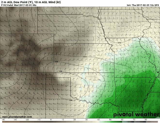
Not sure it is ever that extreme. I would bet on a dry line no father east than I 35 unless flow becomes veered overall like previous model runs suggested
I'm not saying the dryline will be that far west this time but there were a number of events with large eastward model biases last year.
-
1 hour ago, bjc0303 said:
Idk if it's completely dead in the water. 00z ECMWF pulled the dry line back closer to i-35 again.
So did the GFS. here is dprog/dt for GFS.
I'm also not totally convinced this is a done deal. The trend has definitely been for a sharper dryline positioned further west on the GFS. Also, just about every dryline event ends up further west than models have it at this range. I can remember a number of days last year when the GFS had the dryline along or east of 35 and it ended up in western Oklahoma or even the Texas panhandle.

MO/KS/AR/OK 2019-2020 Winter Wonderland Discussion
in Central/Western States
Posted
Building consensus for a period of increased blocking in the 7+ day range. Currently the position of the block looks to focus the core of the cold to our east but overall I’d say blocking showing up is a good sign heading into winter. Definitely a completely different look than the past couple Novembers.