
WhiteoutWX
-
Posts
890 -
Joined
-
Last visited
Content Type
Profiles
Blogs
Forums
American Weather
Media Demo
Store
Gallery
Posts posted by WhiteoutWX
-
-
As long as the global models stay steady I wouldn’t worry about the NAM as much. It was the last to cave in the reverse situation from December of last winter where it was still showing major snows in OK when all the other models had started jumping ship.
That said...this is definitely a low confidence forecast as the parameters that need to come together just perfectly here have a razor thin margin of error on either side. Too amped and it’s congrats Kansas. Not amped enough and you get the NAM solution or what the GFS had been showing a day ago.
-
 1
1
-
-
Cell split after cell split out in western OK
-
So I guess oddly we are right back where we thought we would be 6 hours ago. Storms would struggle south of 40 and west of 35 and the greatest tornado threat would be north and east of OKC.
The cap break at 2 pm turned out to be a fake out.
-
 1
1
-
-
1 minute ago, janetjanet998 said:
a lot of the storms so far west of I-35, including the Stillwater storm now, looks like they are being torn apart by too much shear...you can see this on the visible too as the anvils are ripped from the updrafts ...maybe the CAP is killing the updrafts
they are "tilted".
Definitely looks like the instability/shear balance is off
-
14 minutes ago, WhiteoutWX said:
Core of the storm near Geronimo is rapidly growing. Other cells nearby have died. I'd expect tornado potential to rapidly increase in the next hour.
Soon as I said that is took a downturn. Looks a lot less organized. Hmmm not sure why it appears to be struggling.
-
Cells to the east of OKC look to be quickly organizing. Environment is more favorable this area.
-
1
-
-
Core of the storm near Geronimo is rapidly growing. Other cells nearby have died. I'd expect tornado potential to rapidly increase in the next hour.
-
Just now, Misstertwister said:
Uh, wasn’t today a conditional today for some areas? Now a PDS? You just never know with the weather
Conditional meaning the environment was highly favorable but there was question on if storms would form or not. Now that they're forming the environment can be realized.
-
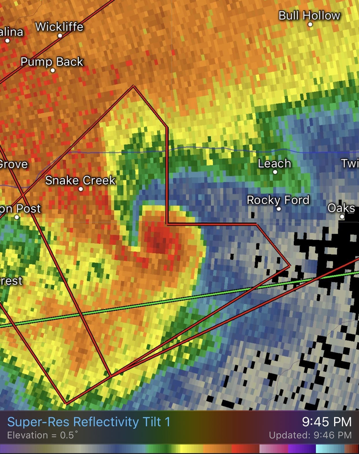
Big wall cloud near Geronimo now
-
Might take a little while for the cells to the SW. Low level shear isnt as great as further east and cells are spaced too close at the moment.
-
3
-
1
-
-
Watch incoming
-
Extensive stratus + height rises maybe too much to overcome south of I40 today away from the boundary. I’m highly suspect of CAMs showing supercells south of there in the warm sector. Agree though that enhanced risk area could be busy later on.
-
2 hours ago, DanLarsen34 said:
A few things I noticed about yesterday that I haven’t seen discussed in much detail yet, but wanted to share to see if they were factors.
1) beyond the capping issues, another problem with the Oklahoma part of the high risk area was storm motions. The few early storms that were able to break the cap, like the one north of the OKC metro, raced north and crossed over the warm front before they ever had a chance to get going. Several cells that attempted do the same later in the evening suffered the same fate. Had storms moved in a more E or NE fashion, they would have had a lot more of the environment to work with before they were undercut by the cold air north of the front, and that which was generated by the outflow from the complex that was ongoing there. That leads me to the second observation.
2) it appears as if the low level jet wasn’t as strong as anticipated. Because of this, the blob of storms along the front, along with other cells merging which formed off the W TX dry line, generated a massive cold pool that rapidly advanced southward in the 5-7 PM time frame. This cold air not only undercut the one lone discrete cell we had, it undercut several updrafts to the east that tried to get going as well. It wasn’t until the low level jet really kicked in around 8-9 PM that we saw storm organization improve, resulting in this brief, but intense tornado east of Tulsa.

I agree with both those points. I remember thinking that the few storms that developed early in the warm sector were screaming north too quickly and weren’t going to have enough time to fully mature. So even if they had formed as advertised that may have caused problems.
-
Ok since I’m one of the people that called “bust” yesterday at 5 pm, here’s why I said it and why I still stand by it. First off, obviously I would never EVER put that out there as a meteorologist on social media. That would be irresponsible and lead people to let their guard down early, in the same way that it is irresponsible when people go on social media and scream the sky is falling. But this isn’t social media and the people on this forum, at least in my opinion, should be able to handle scientific debate and know the difference.
Second, when I said “bust” I didn’t just throw that out there with no reasoning. I was using scientific reasoning and solid meteorological analysis. The cap was clearly holding and it became evident that the storms many of the models were suggesting would fire in southern Oklahoma simply weren’t going to materialize. The reason the high risk was extended eastward into the OKC metro was exactly for that reason. When it became clear it wasn’t going to happen I don’t see what is wrong with calling it as it is unfolding. Again, when backed up by solid reasoning supported by the evidence I just don’t see what is wrong with what is essentially putting out a FORECAST on a forecasting forum. People can debate the semantics on if using the word “bust” is the right term or right way to say it, but I don’t see the big deal using it to describe when a forecast isn’t going as planned, which was all what I was trying to convey.
Third, I noticed a lot of confusion over what constitutes risk areas yesterday. SPC has very rigid and very clear definition of how they verify their risks on their website. Yesterday’s high risk was strictly driven by tornado probabilities, not some combination of hail, wind, and tornadoes. Their high risk was only going to verify with a large number of tornado reports. The strength of the tornadoes or how much damage is completely irrelevant (for better or worse) in how these things are scored. We needed a large number of supercells yesterday to get it done, and it became clear early on we weren’t gonna get that, at least across the eastern half of the risk area.
-
4
-
-
Cold air/outflow generated by this mornings storms wins out. That and the relative lack of warm sector development where the best environment was today were the killers. It happens. But just shows that there is still a lot more to severe forecasting than looking at pretty composite parameters. Thermo/kinematic environment are only one piece as storm mode/number of storms once again proves to be just as important as it has shown to be in past busts.
And yes, this will indeed be a bust. Some people here seem to be confused or forgot that SPC verification of convective outlooks is strictly based on number of reports and has nothing to do with strength of tornadoes, impacts, etc.
-
1
-
-
First legit looking tornado of the day near Mangum now.
-
1
-
-
We've made it to 86 in Waurika in far southern Oklahoma and not a radar return within 100 miles. If it hasn't gone up yet, it ain't gonna happen in the open warm sector past what is already around. Which is basically one storm near Hollis at this point.
-
It's pretty obvious this isn't going to verify as a high risk. Cold air is killing everything along the boundary and not much got going in the warm sector. Yeah its not even 5 pm but there's just not many storms in a favorable environment and no sign that anything new will develop further east before this all lines out.
Will there be a few more tornadoes? Yes I'd say that's likely. Are we going to see a swarm of large/violent tornadoes across a good chunk of Oklahoma. I don't think so at this point.
-
3
-
-
My theory as to why nothing is happening on the warm front: Temperatures are just way too cold to the north, in the upper 40s to near 50. Storm motions are too perpendicular and nothing can sustain itself for long once it crosses the boundary.
Meanwhile, storms in the open warm sector are struggling and the volatile tornado environment there isn't being realized. Cumulus field is all but gone across this area so I don't see surface based convection developing here.
Basically the only remaining area for major tornado threat I see is gonna be the storms entering SW Oklahoma. LLJ is weaker here than further east but will strengthen some over the next couple hours. But how long will they stay discrete is the question here.
-
1
-
-
Kingfisher storm only has about 30 minutes of life before it crosses the boundary. Could spin up quick as it nears the boundary though.
-
I think at this point the worst case scenario string of supercells through the OKC metro shown by the HRRR this morning isn't looking likely. Eventual upscale growth and training storms does have me concerned for flooding this evening though.
Tornado threat looks maximized over western Oklahoma the next couple hours.
-
1
-
-
Newest HRRR suggests little additional warm sector development and then upscale by 00z. Can't say I disagree looking at things at the moment.
-
1
-
-
Radar and satellite trends seem to agree with HRRR that most storms remain north and west of OKC/Moore/Norman areas for the next couple hours at least.
In fact most open warm sector storms look to be struggling right now minus the one north of El Reno.
-
All the CAMs that we’re showing linear/messier modes this afternoon in Oklahoma originated that mess down in SE New Mexico by now. No signs of that happening so far. I’d say early points go to the HRRR on convective evolution today at this juncture.
-
2
-
MO/KS/AR/OK 2019-2020 Winter Wonderland Discussion
in Central/Western States
Posted
The bias with the new GFS (FV3) is actually to underdo precip on the backside of lows. Doesn’t mean it will always do that but something to keep in mind.
Last three runs of GFS have been very consistent overall with the placement of the swath of snow from central OK on northeastward. It’s bounced around a bit with exact totals but that’s to be expected.