showmethesnow
-
Posts
7,250 -
Joined
-
Last visited
Content Type
Profiles
Blogs
Forums
American Weather
Media Demo
Store
Gallery
Everything posted by showmethesnow
-
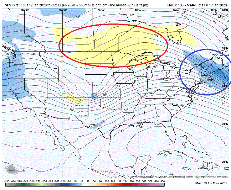
We continue to see the run over run changes that we want. Snapshot at 105 hr on the changes from 12Z compared to the 06Z. Note we continue to see an increase of the pressures over top of our system. We are also seeing the confluence lag even farther behind in the NE. And we are also seeing a slightly deeper dig of the trough in the west.
-
It's not so much the slower arrival time of the system that we need to worry about. It is the arrival time of the system compared to the high to the north. With the confluence lagging behind longer and deeper we are seeing the High pressure being locked in longer and being slowed down quite a bit on it's move eastward. So though we are seeing this system arriving later it is in fact coming in quicker in relation to the cold.
-
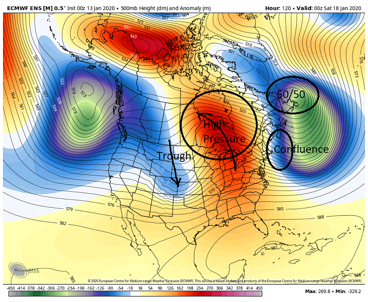
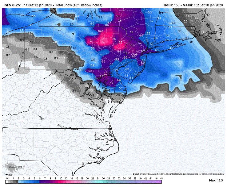
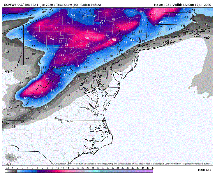
We continue to see run over run improvements within the Euro for next weekend. Still 5 days out so things can very well degrade but as of now we are still probably good for a general 2-4, 3-6 through the cities and north from WAA snows. Couple of things I will point out as far as what the run over run improvements are and they generally involve with what we are seeing with the 50/50 and it's associated confluence in the NE and the higher heights/high pressure we are seeing in southern Canada. The 50/50 has been trending stronger and it's general timing with the incoming system and associated western trough has improved. One other thing of note is that we are seeing a string of NS energy trailing behind this 50/50 that has been digging deeper and deeper south in the NE in front of our incoming system. In a nut shell these changes are helping to keep confluence to our NE locked in longer as well as dragging it farther south. These are good things as it is helping to lock in the High pressure to our north longer which also is playing a part in keeping the CAD in place longer as well. What we have also been seeing is that we are continuing to see a strengthening of the higher heights over top in Canada run over run. So what all this adds up to is deeper and longer lasting CAD through the region as the WAA precip moves in. Another thing to point out is that we have been seeing an adjustment of our western low's track SE as well as a general weakening which is what we want to see. This combo helps to take the threat of having the best WAA moisture running to our west and north somewhat off the table as well keeps the SW flow weaker where it will have a much harder time of scouring out the CAD. Now there is one thing I want to point out as a possibility although I don't particularly think it will happen at this time. What we have been seeing with the higher heights over top in Canada has been a move run over run towards them hooking up and over the western trough dropping in. So what we have generally seen over the last several days it that we are seeing a deeper dig with the trough as well as a quicker turning of it's axis (not so much on the latest run compared to the 12z). Now at this time we are seeing the through close off to our N/NE well after it could have any impact for us. BUT... we continue to see those stronger heights in Canada continue building up and over that dropping western trough there would be a very real chance of seeing the 500's closing off much sooner to our west. Not only that, but there would be the possibility of the 500's actually getting cut off from the NS flow in response to the higher heights through southern Canada. Now if we were to see one or both of these things occur it would change the dynamics for after any WAA aloft snows fell. Now what this would possibly mean for our region it is hard to even speculate until we actually saw it but I could see it potentially put coastal development into play for our region. But again I am not necessarily expecting this I just thought it might be worth keeping an eye for.
-
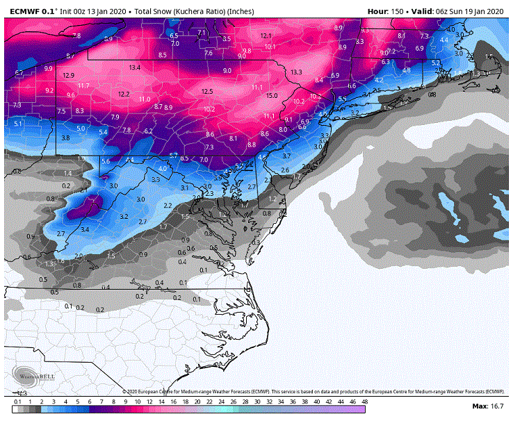
Not that it means much but I would probably favor a ground truth more so towards the Kuchera. Never been a big fan of the ground depth maps as they quite often (read most of the time into that statement) understate the snow we actually see except in very marginal setups. This setup on the thump is far from marginal and only becomes an issue as we see a warm nose start sneaking in at the mid and lower levels at the very tail end of the WAA precip. Otherwise the temp profile throughout the column is better then fine for almost all if not all of the thump. But as I said it really doesn't mean much as it is one run and we are more then likely going to see the models flip back and forth for the next few days. ***Was a lot to like with what I was seeing on the Euro. Might break it down a little later.
-
Latest GEFS was interesting. Quicker system with an adjustment of the track SE. Now also showing secondary lows popping up off the coast anywhere from around OBX up to Jersey. Actually had some very good hits pop up (3) of 6+ DC north. With totals 10+ in central and N MD. A fourth was there as well with 6+ around the PA line and 12+ just north of the line. Other more modest hits for our region were also in the mix. Needless to say we saw an improvement on the means especially in northern sections and north.
-
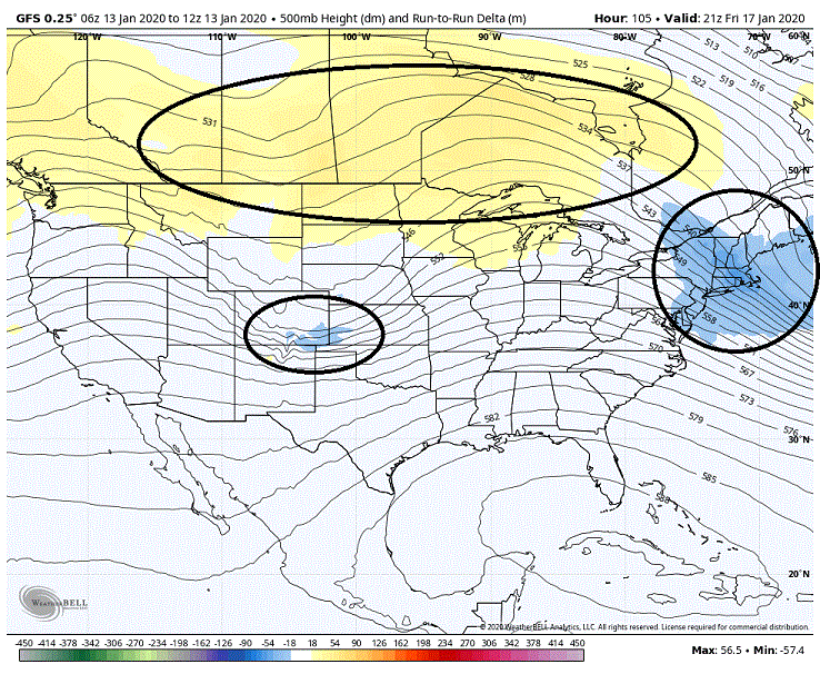
Just one run (06z gfs) and probably doesn't mean much in the grand scheme of things but I did like what I saw as far as adjustments over the 00Z run. The map below shows the changes we saw from the 00Z gfs to the 06Z gfs. Notice that we saw an adjustment to higher heights over top our cutting system as well lower heights to our NE. Higher heights over top help to keep the system more suppressed to the south as well as helps keep the low from ramping up to quickly with a stronger SW flow. Lower heights to our NE show that the confluence is holding a little longer which helps in keeping the CAD locked in longer as well as helps to mitigate northern latitude gain as our cutting low progresses eastward. Not surprisingly when we look at the surface we saw a weaker low tracking SE of the 00z track. We also saw the CAD hold on longer/stronger as well.
-
Guess I will throw a life preserver for those drowning in despair over the storm next weekend. Your welcome.
-
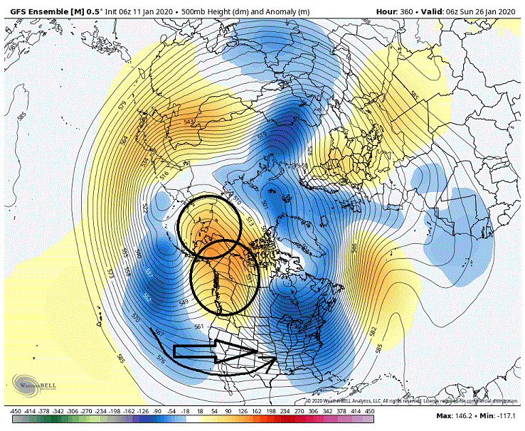
Not going to dive deep into it but we are getting some very interesting looks on the EPS day 9/10 onward until the end of the run. And if the models are to be believed these looks would extend beyond the end, potentially a good deal beyond. But the devil is in the details and until we see these looks closer in time where the smaller features are not being washed out by smoothing we are left guessing for the most part at what to expect. I will say though, I like very much what I am seeing at this time and if it holds and we can get a little bit of blocking thrown into the mix I believe it could be a very exciting week or two coming up.
-
We also see a shift north on the EPS snowfall maps as well where the 2" line is just north of Baltimore at this time. Not going to count but I would say most of the snowfall means are being produced by roughly 1/3 of the members with a hand full or so of them being fairly significant events. Interestingly enough we have a slightly better look for locking in the CAD and yet we are seeing it scoured out quicker. This is probably due to the EPS also seeing a stronger SW flow due to a stronger cutting low into the Lakes. To be honest I question the CAD being scoured out so quickly with a low that is cutting so far to our west and the good CAD signature we are seeing beforehand. Also of note we saw a slight adjustment of the cutting lows track to the NW. Would really like to see this low farther to the east on its cut as well as a quicker arrival time to take advantage of the cold while it is locked in. Otherwise we are probably on the border line at this time of seeing all the good overrunning moisture running to our west.
-
Overnight Euro run vs. 12z has a stronger low cutting into the central Lakes with a very similar track. Also seeing the CAD scoured out quicker and this is probably due to a combo of the lead low (in the NE rotating up through the 50/50) moving out a little quicker and the stronger SW flow associated with the stronger cutting low to our west. So not surprisingly we saw the snowfall maps shift significantly north as to where the 1 inch line now resides around the PA line ,
-
Randy actually owns the site. And if once in a blue moon he posts a banterish post I think he is more then entitled too.
-
Easiest thing to look for is to see a slower departure of the lead low to our NE moving up into the 50/50. Keep that low hanging back somewhat with the confluence associated with it and we have the mechanism to force a transfer. You could also look for much stronger high pressures overtop and to our NE in southern Canada to force a quicker transfer. Or a combination of both of the above.
-
Sort of a balancing act. The closer the low gets to the Aps on its track the better the moisture feed but also the stronger the SW flow we see in the lower atmosphere to erode out the CAD. But what is popping up on the Euro at this lead implies we could be looking at a beast of a CAD setup which will be very difficult to overcome. If we were to see a track farther to the east it could very well be a case where the mid levels where snow is made (above 850's) are torching and yet the lower levels are an icebox (below 850's). Basically a thump to heavy sleet. Also the closer approach is more conducive to see a transfer occur over top where the precip gets shut off before the lower levels warm too much to change things over to freezing rain/rain.
-
Night and day between the current run snowmap vs the 00z. ooZ was basically nothing for the region vs the 12Z...
-
Yeah, kind of confused myself with some that are already dismissing this threat and looking beyond it. I like the look and it is one where we can typically score 2-4, 3-6 through the region before a flip to other frozen and/or rain. Not to mention I am leaning heavily on seeing the primary end up tracking farther S and E compared to what it is spitting out now. Could very well be a thump to drizzle as we see the low transfer over top to the coast.
-
Much stronger CAD signature showing up on the Euro compared to the 00z run.
-
Everyone? You mean maybe some were? I know I was no where close to canceling anything especially considering we were in early January. Been at this too long to get caught up in all the hype (both good and bad) we see sometimes.
-
Bigger storms all the way. And this isn't so much because I am big game hunting, which I always am , but more so because I think the odds are better if we go that route. Right now from what I am seeing on the models the trough positioning looks to set up a little too far east for progressive systems and I have a fear that if we don't see some form of blocking to slow the flow we will run the risk of seeing systems suppressed as they run to our south (Congrats S VA/N Carolina). But on the other hand the trough positioning is pretty much primo for systems if they amplify which we would see with blocking. And I don't necessarily believe it would be a one shot and we are done deal to boot. Could be a case of one system amplifying and nailing us and then providing a transient 50/50 for a follow up. And seeing as the models at this time are suggestive of this general setup being locked in for awhile beyond the end of the extended it would provide potentially a wide window to score when we could possibly be talking transient blocking. So Big Dog all the way as far as I am concerned.
-
Yeah. So besides the obvious, trough/closed low undercutting ridging, you can also get split flow setting up when you start seeing large gaps between height lines.
-
Thought I would add something. PSU threw out analogs out the other day that weren't promising for our snow chances as far as a -EPO/+PNA combo. Good reason for that as that pretty much overwhelms the flow throwing a deep trough into the eastern portion of the country. This look is not what he is referring to though. Now this look above would clock in as a -EPO and a fairly strong +PNA. This is where looking at indices alone can be misleading. What we actually have is a -EPO and a very strong northern based +PNA. If you notice to the south we are seeing a flat flow with hints of a split flow and southern stream involvement. This is actually not a bad look at all if we can get some backing of the flow in the east (believe PSU mentioned this as well on his analog post about needing blocking up top) otherwise we are looking at progressive systems.
-
That look is more favorable for SS interaction. Up in the PAC west/EPO region we really aren't seeing much of a split of the flows as the distance between the height lines are staying uniform.
-
Really am starting to like the potential of what we are seeing beyond day 10 on the models. And beyond the end of the extended as well as this has the looks of something that could setup for a time. Will pretty much be dependent on if we can get something to slow the flow in the east (NAO/50/50). We see that and I think we are ripe for a fun time.
-
Another area we might want to keep an eye on is what we see in the PAC NW. Think given the current setup in the longer range this has better odds of producing then from the weak split flow showing up off the SW coast. What we are seeing is a split flow up over the EPO ridge with the NS and this is being undercut into the PAC NW by the PAC stream. With the troughing/piece of pv to the west providing ample energy to both streams. Given the current setup with a fairly aggressive trough in the east this is actually a good look for potential..
-
My initial glance at the EPS leading into our potential storm for next weekend was pretty much a, 'Oh crap' moment. Stronger height builds and ridging in front of our incoming system compared to the 12z and we were also seeing the NS with a weaker dig and a farther west track on its eastward movement. Height builds were pretty much suggestive of more warming leading into the system . As far as the NS track it pretty much takes the low running through our region or to our south off the table. As I said, it was a, 'Oh crap' moment. But diving into it a little bit and I realized it was actually a more promising look for frozen through our our region. What I didn't initially pick up on was that we were seeing much stronger height builds over top around the Hudson Bay which was translating to stronger higher pressures on the surface in Canada. We were also seeing the a stronger, slower and farther SE signature on the 500's through the 50/50 region. This setup is actually a fairly decent upgrade from the 12Z for maintaining CAD (cold air damming) in the east. One other thing, with the farther west track of our surface low the stronger southerly flow at the lower levels also shifts farther west making it that much more difficult to scour out the CAD. And below you can see the surface representation 12 hours later when precip is starting of what the 500's above produced. Strong high over top with a 50/50 helping to slow it down. This combo is producing a strong CAD signature east of the Aps. Farther west low is keeping the stronger southerly surface flow west of the Aps. Not surprisingly we saw an increase on the snowfall maps (looking at them more so for the frozen potential then for actual snow). The run was actually close to an all frozen event (snow, sleet, freezing rain) for N and W of the cities. Throw in a little better temps in the lower levels for after we lose the mids and we are talking Fz rain or sleet to end this.
-
I'm all.... At least until tomorrow.