
AlaskaETC
-
Posts
2,521 -
Joined
-
Last visited
Content Type
Profiles
Blogs
Forums
American Weather
Media Demo
Store
Gallery
Everything posted by AlaskaETC
-
Expected to get another 8-12" today, with 16" a possibility it seems. I thought the NAM was being the NAM but I guess it was pretty spot on.
-
-
Nice little early snowstorm for my backyard in Central WY.
-

Front Range snowstorm nowcast/conditions 3/13-15
AlaskaETC replied to mayjawintastawm's topic in Central/Western States
Anywhere in the Front Range would get you plenty of snow every year. -
Front Range snowstorm nowcast/conditions 3/13-15
AlaskaETC replied to mayjawintastawm's topic in Central/Western States
NWS Riverton on Twitter: "⚠️All-Time Record Snowfall in Casper, WY⚠️ This snowstorm could be a top-3 all-time snowfall for Casper, WY. Here is a look at where the current storm stands against the all-time snowiest events. #wywx https://t.co/YGfK06mhBa" / Twitter 26.3" in Casper, 21.2" today alone. I was a little lazy in measuring, but I thought we got way less than that! The radar returns weren't looking great, but I guess it was radar shadowing or something. -
Front Range snowstorm nowcast/conditions 3/13-15
AlaskaETC replied to mayjawintastawm's topic in Central/Western States
The NWS snow obs were pretty much in line with the Euro/NAM about two days ago. -
Looks like the HRRR really handled this storm well, along with the NAM and Euro.
-
Front Range snowstorm nowcast/conditions 3/13-15
AlaskaETC replied to mayjawintastawm's topic in Central/Western States
Custer County, decent elevation in that area -
Front Range snowstorm nowcast/conditions 3/13-15
AlaskaETC replied to mayjawintastawm's topic in Central/Western States
About 12" here in Casper. A little bit under the forecast I think. Seems like the moisture had a tougher time getting here than predicted. -
Front Range snowstorm nowcast/conditions 3/13-15
AlaskaETC replied to mayjawintastawm's topic in Central/Western States
NWS Boulder on Twitter: "What does this winter storm look like from space? #COwx https://t.co/IGcFsIK9w6" / Twitter -
Front Range snowstorm nowcast/conditions 3/13-15
AlaskaETC replied to mayjawintastawm's topic in Central/Western States
Cheyenne with nearly 26" of snow. Jackpotville -
Front Range snowstorm nowcast/conditions 3/13-15
AlaskaETC replied to mayjawintastawm's topic in Central/Western States
Denver really cashed in today. The dry slot last night looked brutal. -
Front Range snowstorm nowcast/conditions 3/13-15
AlaskaETC replied to mayjawintastawm's topic in Central/Western States
Similar to what happened in Denver I think. -
Front Range snowstorm nowcast/conditions 3/13-15
AlaskaETC replied to mayjawintastawm's topic in Central/Western States
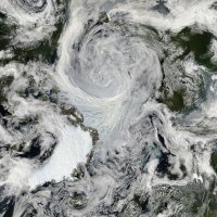
This is textbook stuff. Worth saving these images. RAMMB/CIRA SLIDER: GOES-16 (East; 75.2W) Satellite Imagery: CONUS Sector: GeoColor (CIRA) (colostate.edu) -
Front Range snowstorm nowcast/conditions 3/13-15
AlaskaETC replied to mayjawintastawm's topic in Central/Western States
This storm sure is a beauty. GOES-East - Sector view: Northern Rockies - GeoColor - NOAA / NESDIS / STAR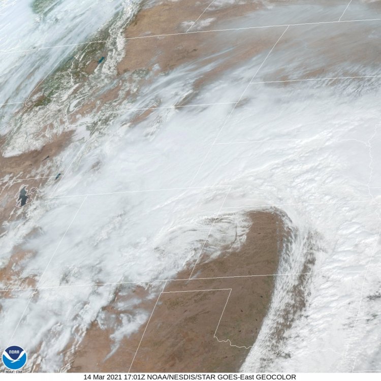
-
Front Range snowstorm nowcast/conditions 3/13-15
AlaskaETC replied to mayjawintastawm's topic in Central/Western States
This from NWS Cheyenne earlier, but this Forecast Discussion is worth reposting - -
Front Range snowstorm nowcast/conditions 3/13-15
AlaskaETC replied to mayjawintastawm's topic in Central/Western States
Lol sounds like a dc ob smh Cheyenne looks like Jackpotville right now -
Front Range snowstorm nowcast/conditions 3/13-15
AlaskaETC replied to mayjawintastawm's topic in Central/Western States
The radar returns look a little dry across the board. I wonder if the convection further east is stealing some moisture. -
Front Range snowstorm nowcast/conditions 3/13-15
AlaskaETC replied to mayjawintastawm's topic in Central/Western States
Bit of a dry spot developing on the radar between Casper and Douglas. A bit concerning but I assume it will fill in soon. -
Front Range snowstorm nowcast/conditions 3/13-15
AlaskaETC replied to mayjawintastawm's topic in Central/Western States
The 0z 3k NAM nukes the Cheyenne area from 12:00AM-7:00 AM. It is still kind to the Casper area, giving 20-25" verbatim. -
Front Range snowstorm nowcast/conditions 3/13-15
AlaskaETC replied to mayjawintastawm's topic in Central/Western States
The 0Z HRRR plasters the entire area from just south of Casper to Cheyenne. Wide swaths of 30" or more -
Front Range snowstorm nowcast/conditions 3/13-15
AlaskaETC replied to mayjawintastawm's topic in Central/Western States
Starting to accumulate here. Looking to get 8" or more overnight according to the HRRR. -
I've noticed a tick up north in some of the HRRR and other mesoscale runs but maybe that's just me.
-
Front Range snowstorm nowcast/conditions 3/13-15
AlaskaETC replied to mayjawintastawm's topic in Central/Western States
Starting to pick up here in Casper. A slight wind, 32 degrees. -
Front Range snowstorm nowcast/conditions 3/13-15
AlaskaETC replied to mayjawintastawm's topic in Central/Western States
From the looks of it, the mean is also very generous for most areas.


