

das
-
Posts
2,233 -
Joined
-
Last visited
Content Type
Profiles
Blogs
Forums
American Weather
Media Demo
Store
Gallery
Posts posted by das
-
-
Oops, posted obs in the other (wrong) thread. Just passed 2" here in NW VT. Looks like the 1-3" will be more like 2-4" up here. 16F/15F, calm wind.
-
4 hours ago, Ginx snewx said:
I saw that. Looks good for 4 to 8

Looking like good guidance for here in NW VT. Just passed 2" at 11am here. 16F/15F, calm wind.
-
 1
1
-
-
1 hour ago, powderfreak said:
That NWS met now has 11.4” Storm total in Milton and only 1” last hour lol.
I think we are around 6.5” here in Stowe Village. Steady snow still going.
It was pretty vigorous. I just passed 7" here in Charlotte and 3.5" of it came in 1h45m from 3:45pm to 5:30pm. The convergence was definitely greater 20mi to the north in Milton so it's likely a legit measurement as they were under it for like 3 hours and they started with 4 or or so already while I only had a measly 2.5" when it started. Steady snow still going here. It's going to be a nice 24 hours upcoming as waves of moisture continue to wrap around the GOM low.
-
1
-
-
1 hour ago, powderfreak said:
Starting to crank back this way. A NWS MET just text me 2.9” in 1-hour in Milton just north of BTV.

The valley convergence has pushed far enough south down the valley to just now reach me. 1/8mi. visibility, it looks like. I'd guess this is 2"/hr rates. We'll see in a bit.... 24ºF/19ºF, N23G31, it's howling out there.

-
10 hours ago, Drz1111 said:
As an aside, if I ever went back to school the project I want to do is applying this to the west to see if you can use it to untangle the different rain shadows and such. The simple rain shadow / terrain explanation doesn't do a very good job of predicting Western climate.
If ever you think about it seriously, talk to the NWS Burlington team. They do serious work in this area on nearly a daily basis during the winter. For example, here’s their AFD from this evening:
000
FXUS61 KBTV 020336
AFDBTV

Area Forecast Discussion
National Weather Service Burlington VT
1036 PM EST Mon Feb 1 2021

.SYNOPSIS...
Accumulating snow will make for difficult travel conditions
across the area, especially during the Tuesday morning commute.
Southern areas will only see light snow Tuesday night, but
northern areas will have the best chance for accumulating snow
and continued difficult travel conditions through Wednesday.
Overall looking at six to twelve inches of snow tonight through
Tuesday night with slightly less amounts for portions of the
Saint Lawrence Valley and parts of northeast Vermont.

&&

.NEAR TERM /THROUGH TUESDAY NIGHT/...
As of 1003 PM EST Monday...Overall, no significant changes were
made to the forecast. Only small tweaks were needed to speed up
arrival of precipitation by an hour so as snow is already being
reported at Rutland and Lebanon, NH. This precipitation shield
will continue to move into northern NY and VT overnight.
Interesting to note that east of the Greens temps and dewpoints
are in the 20s while the northern Champlain Valley and northern
New York remain firmly in the single digits/low teens. Have
adjusted the temp forecast accordingly based on these latest
observations. Still thinking that as the warm front continues to
move northward these locations will warm into the 20s by
morning.

Previous Discussion...Forecast remains on track for widespread
snow event across the North Country tonight through Tuesday
night. Only change to headlines will be to include eastern
Clinton County in the Winter Storm Warning. All other warnings
and advisories remain in place. Bottom line much of the area
will see six to twelve inches of snow with slightly less amounts
over parts of the Saint Lawrence Valley and northeast Vermont.

Snow spreads from south to north tonight and especially after
midnight and continuing through the morning commute on Tuesday.
Looking at a period of difficult travel conditions during this
time period. Main mechanism for the snow during this period will
be pronounced 700 mb frontogenesis lifting northward across the
area. In addition, favorable alignment of omega and snow growth
support the idea of a burst of steadier snow...around an inch
per hour. The snow will taper off from south to north during the
late morning and afternoon hours with best forcing lifting to
the north. However, flow will become more northerly Tuesday
night and moisture wrapping around the upper low will support
the idea of snow becoming more widespread across far northern
New York and northern Vermont. Northerly flow and very low
Froude numbers support the idea that snow should also be in the
Champlain Valley and not just confined to the higher terrain.

&&
-
2 hours ago, Typhoon Tip said:
I'm sorry ... "froude number" ?
Continuum fluid dynamics defined as the ratio of the flow inertia (at the boundary layer) to the external field (at the crest level) that calculates blocking.
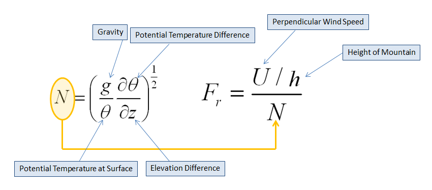
BTV has experimental output they use to determine if snows will fall on the lee side of the crest, the windward side or, under extreme blocking conditions (ie., <0.50), back up into the valley. It's found here:
https://www.weather.gov/btv/froudeALL
I posted this earlier, I think, but here's the primer on it:
https://www.weather.gov/btv/froude
More scholarly reading:
https://web.stanford.edu/~fringer/publications/mayer-jfm-2017.pdf
-
1
-
 1
1
-
-
6 minutes ago, J Paul Gordon said:
Looks good for ORH since I'm not looking forward to 15 inches of semi frozen water.
Does not compute.
-
 1
1
-
-
First indirect influences of the storm here in Charlotte: LES band has popped on the increasing N low level winds. Fluffy dendrites FTW! Temp is up to 4F.
-
1
-
-
-5°F / -11°F here just south of Burlington. Probably not much mixing with the storm here. :^P Virga is now only 3 counties to the south away. It’s going to be a long day of radar hallucinations waiting.
For those of you struggling with the NWS “upgrade” of the radar page, here’s my favorite mosaic from Univ of Washington. Change the number of frames there in the link for longer or shorter loops and to auto if you want it to auto refresh every 6 minutes:
https://a.atmos.washington.edu/~ovens/wxloop.cgi?radar_us_full+30+-noauto
And, if any of you want to pass the virga watching time and read up on Froude numbers for blocked flow, here’s an excellent primer from the team at NWS Burlington: -
-1°F / -5°F here in the Champlain Valley. Looking forward to 4-6 hours of WCB tomorrow night with the ~700 frontogenic max pushing thru then all eyes are on the froude number as blocked flow commences.
-
3
-
-
1.1" here in the Champlain Valley. Just enough to pretty up the 3" of crusty snow that's been sitting around for the last 3 weeks.
-
.25” waaaaaay out west here in the Champlain Valley. In the pre-dawn hours. Maybe we’ll squeeze another quarter inch tonight for a whopping 0.5” storm total. The freezing fog is fun tho.
-
1 hour ago, Hoth said:
This brutal January sun angle is melting all my snow!
Truth.
0.7” was the grand total in Charlotte last night. At least it all came in a 1.5 hour period so it looked nice whitening up the snow from the 2nd.
-
1
-
-
16 hours ago, Damage In Tolland said:
Did you guys up north that got 2” or more melt today or did it stay below freezing? Not Phin or Freak who are in their own microclimates. I mean normal locations.
Topped out at 31°F yesterday with minimal sun only as it was setting. It’s all still here in the Champlain Valley.
-
1
-
-
3.8” was the storm total in Charlotte. It feels like a central Maryland snow. Dense, high water content. Might have to make a snowman.
-
3.1” here in Charlotte with 32dBZ returns overhead and more incoming from the WSW. Looking at correlation coefficient, the mix line stalled just south of Middlebury and recently shunted east as winds veered. Nice morning so far.
Edited to add: 30.9°F here at the house. Going out for a run!
-
Column has finally saturated and light snow has commenced. 1/4” in the first hour. 28.1°F here in the northern Champlain Valley.
-
1
-
-
26.1°F and a passing snow shower in Clarksburg. It’s 61°F and raining here in Vermont.
Merry Christmas, everyone!
-
2
-
-
Hi there, all. IP just turned to ZR at the house in Clarksburg. 31.1F / 31F. Storm total so far is 2.1" SN/IP. I'll be enjoying this one from the place up in Vermont. 14F / -3F here now and only expecting 2-3" of SN as the storm skirts by to the south and east.
-
3
-
-
1 hour ago, 40/70 Benchmark said:
Oh, agreed. Its not a concern for snowfall. Frankly, if you need 24 to drop over a foot of snow, than then you have some paltry dynamics.
Totally unrelated but I had a crash course in this. In the 72 hours ending at 3am this morning, there were 52 hourly obs of snow here in Charlotte and a temp that ranged from 24F to 29F. For a whopping 3.6" of snow. And, a max of 2.9" OTG.
-
There could be three tropical storms (or stronger) in the Atlantic basin at the same time in the middle of November. Incredible.
-
1
-
 1
1
-
-
1 hour ago, Prospero said:
Edit: I can't seem to find a radar right now.
Here you go:

-
1
-
1
-
-
59 minutes ago, jpeters3 said:
Just looked it up. Looks like it's a C-130. I guess they attached the rocket booster.
(sorry for the banter)
-
1
-
-
Flurries in Clarksburg. Temp is 38°F. It’s good to be in the area for the week!
-
3
-

February 10-12 event obs
in Mid Atlantic
Posted
33°F/32°F in Clarksburg with SN. Dirty snow is white again, new snow on all elevated surfaces.
Man, the radar sure looks juiced to the WSW entering WV along the low level jet. It will be interesting to see where the heaviest snow sets up running west-east in MD.