

BombsAway1288
-
Posts
1,376 -
Joined
-
Last visited
Content Type
Profiles
Blogs
Forums
American Weather
Media Demo
Store
Gallery
Posts posted by BombsAway1288
-
-
Just now, HoarfrostHubb said:
Weather underground app has me getting 5-8”
Blizz must have hacked it....or James did
Those forecasts on that app are about as useful as the old weatherbug and weather channel app forecasts. Seen them go from showing a 12" blizzard to 2" "snow shower" in one update
-
 1
1
-
-
2 minutes ago, SnowGoose69 said:
It’s remarkable though how often it can tip you off that other models may be on their way to adjusting. The wave that hits NJ/PA/MD Friday the navgem consistently was north the last 48 hours of almost everything other than the NAM. Today everything else came north
Just a question, that's (NAVGEM) the former Navy NOGAPS, correct or I'm completely off?
-
Just now, CoastalWx said:
Hrrr is like 1-2” lol.
Ugh, not good to hear. That would be a disappointment following days and days of consistency in the models showing at least 3"-4"+.
-
16 minutes ago, dryslot said:
That would be quite the shellacking on the fv3 for Monday, To bad it sucks.......lol
Ugh. I would almost rather have that model be cold and suppressed. Has a cold bias, correct?
-
19 minutes ago, WEATHERMINATOR said:
ITs the same track as the eps and eps is the best model. In fact the eps is a bit southeast of the icon so that gives you that extra 50-60 miles of leeway for Long Island to enjoy a mostly snow event
It is. The track is perfect just like the EPS. Just need the global OP's to hop on board although in a winter like this with so many last minute changes, I'm not too sure I would want to be in the OP's bullseye 4-5 days out. The EPS? That's a different story. Put me in the bullseye of that any day!
-
 1
1
-
-
7 minutes ago, WEATHERMINATOR said:
Icon is a foot of snow for Central Park. Very impressive snowstorm
sunday night and moves out by Monday at 7-8am
You have to give pause that it's the ICON though. I would love that solution as much as you guys but sadly, it's the ICON showing that right now
-
14 minutes ago, EastonSN+ said:
Wow yeah. Too bad its the ICON.
Certainly a fast mover but that would be the perfect track for the 95 corridor and at least 3 out of the 4 major cities. You're right though, too bad it's the ICON
-
9 minutes ago, Hoth said:
Yes, I'm primarily referring to expected conditions in KHTH. (I realize that's Hawthorne NV, but this winter my hood might as well be.) Good luck up there.
Thanks. Sounds like we're going to need it if the HRRR keeps getting drier and drier
-
1 minute ago, Hoth said:
Another garbage system. At least it's all snow.
Maybe down there in Hamden, CT. Not here.
Going to be one of the best "storms" we've had on the Mass coastal plain this season!
-
Just now, BombsAway1288 said:
That's actually not nearly as bad as I thought it was going to be. You've toned down nicely
3 minutes ago, USCAPEWEATHERAF said:I could see 6" + from HYA eastward to Provincetown. NWS Taunton SNOW PROB map shows 19% for 8"+ for CHH.
Nevermind

Lay off the 8" numbers James. Moving way too fast for that.
6" is most imo
-
15 minutes ago, USCAPEWEATHERAF said:
February 27-28th 2019 Clipper Snowfall Map
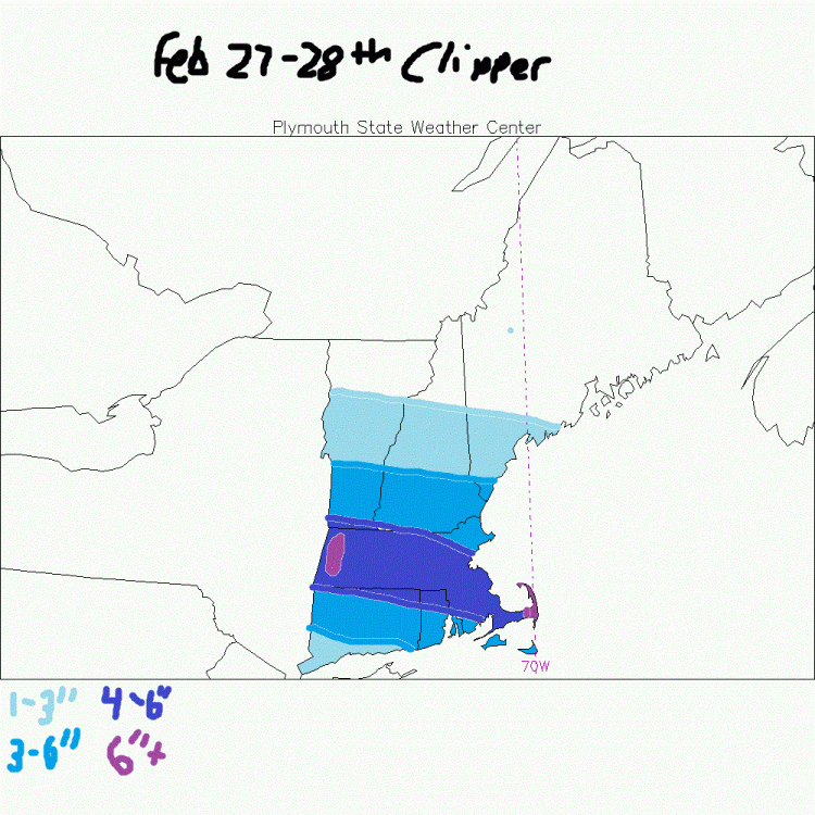
That's actually not nearly as bad as I thought it was going to be. You've toned down nicely
-
1
-
-
5 hours ago, WEATHERMINATOR said:
Snowing lightly in armonk now. Precip seems more south than any model shows. Hopefully we get a surprise
Huh? It doesn't really, at least right now. In fact, it looks pretty spot on from the modeling
-
14 minutes ago, SnowGoose69 said:
Didn’t even notice til now Boston got out of the least snowiest winter. That 1.6 they reported the other night seems fishy to me. Was that an overmeasurement vs their continuous undermeasuring? I don’t recall their vis ever going below 2-3SM and it only snowed for 4-5 hours
I'm right next to KBOS and you're right in that there was continuous undermeasuring there, I'd say until the New Year this year. Since then, every one of their measurements has matched mine pretty well including the 1.6" measured a couple of weeks ago. Maybe they went with a change of persons/procedures for the beginning of this calendar year?
On another note, the EPS looks amazing. Benchmark mean right there, 2 runs in a row with the most recent run looking even better.
That'll put me at ease for the next 12 hours for a d5 threat, no matter what any of the global OPs show for 18z and 00z tonight
-
3 hours ago, USCAPEWEATHERAF said:
With 12-15:1 ratio, Cape could see 4-8" of snow.
Called it! I don't think you're seeing 12:1 ratios let alone 15:1.
Good luck though!
-
26 minutes ago, dryslot said:
You make it sound like i'm complaining, Far from it, I'm at dead normal, I was answering Mikes comment of what is considered big this winter, And storms of 6" would be big as they have been far and few, Of the 21 events, 4 have been over 6" and 2 that were 5" ones, The rest were 4" or less, But in a normal year, We would have seen some 12"+ events.
See my last post on the last page
-
3 minutes ago, Damage In Tolland said:
Those 4-6” amounts look south of there
You're thinking higher like 3-6? Most guidance and what I've read from mets and others on here, they're leaning 2-4
-
13 minutes ago, CoastalWx said:
What did he say that was wrong?
Nothing really. At first it came off as little bit of complaining about not getting a BIG coastal this year while still having a good count this year.
I wasn't trying to be rude either, just my type of conversation that probably translates better in person than in typing. My apologies.
That's what climo does for you sometimes. Good numbers in an overall bad year
-
Pete B. was surprisingly bullish which normally would mean doom for us but he's been pretty good this year from what I've seen.
Has 3"-5" for all of SNE and 1"-3" from the NE Mass/NH border north
-
26 minutes ago, dryslot said:
Then i misread what you said, But there has been no "big leagues" other then where i mentioned and significant ones have been far and few, One in Nov, Two in Jan and on in Feb here, And a bunch of nickels and dimes.
Really? You have 70" of snow on the year with "nickle and dime" events while us southern NE coasties have been teased and tortured all year. I would normally prefer a big dog too but in a year like this one I'll take whatever I can get
-
1
-
 1
1
-
-
2 minutes ago, weathafella said:
Signal for d12 or so but who cares that far away...
Hmmm. Def would like to see the EPS showing next weeks action instead of the OP. This year has been d10 OP threat after d10 threat with nothing to materialize
-
4 minutes ago, weathafella said:
EPS is solid....brings the bulk Saturday night/Sunday
Well that's certainly a good sign.
Does it have next weeks threats also?
-
Interesting EPS run coming up. Hopefully it offers up the goods too as it's the preferred guidance for the range
-
Maybe the best entire run all season.
3 threats. Sat Mon and Wed.
Just one please!!!!
-
1 hour ago, weathafella said:
I don’t understand why with such a lack of gfs consistency on this....
It really has swung back and forth the last couple of days. Like over 1000 miles back and forth. Pattern causing havoc with it?
Whats the Euro been showing for it?

March Disco
in New England
Posted
Well snowman19 disagrees with you. He's thinking super warm cutter. I'm surprised he hasn't responded to you yet. Oh wait, he must have used up his 5 posts/day today. Oh well!!!!!!