

BombsAway1288
-
Posts
1,376 -
Joined
-
Last visited
Content Type
Profiles
Blogs
Forums
American Weather
Media Demo
Store
Gallery
Posts posted by BombsAway1288
-
-
1 minute ago, WinterWolf said:
YUP! Or Dr. No says we rejoice...but I think it goes east some from earlier just like most of the 12z suite.
Almost certain it goes East with the UK following the 12z trend. I'm almost more interested in what it has for Monday
-
11 minutes ago, Baroclinic Zone said:
Let's do this!
Please send this to that person who was complaining about the SW Connecticut snowhole lol
-
2 minutes ago, weatherwiz said:
Well go big or go big

Wow. That's the exact opposite I was expecting from you lol. Hope you're right.
-
7 minutes ago, JC-CT said:
1.25" from haverhill to newark
Garbage, garbage, garbage model. I would love to see it verify but don't think it will. Lets see the UK and Euro match up with it, then we may have something
-
With the shift in the morning models today for tomorrows storm, I'm not going to take any solution on these models seriously for Monday's storm until like Sunday afternoon. Even then I'll be on edge
-
1 minute ago, 40/70 Benchmark said:
The kick due east is what bums me out...that would be a killer here.
You'll probably do pretty good on Monday and any other events next week. I wouldn't be too bummed. Would love to live in you locale. Prime for nor'easters
-
9 minutes ago, USCAPEWEATHERAF said:
GFS is the same, I don't see any southeast movement everyone says they saw.
You seriously need a timeout or something. It clearly did tone down from the 06z run. You're purely wishcasting at this point and only seeing what you want to see. It gets quite annoying after a while
-
 1
1
-
-
11 minutes ago, wxsniss said:
12z RGEM definitely not as coked out as 6z, but still a big hit (i.e., warning) for eastern SNE...
12z on right
Trend so far at 12z has been to tug this further east...
11 minutes ago, USCAPEWEATHERAF said:RGEM is all snow for Cape Cod even ACK. Provincetown seems to be the place to be in SNE this storm. 12-20"
Huh??? Not according to the maps posted above. Looks like a mix and/or rain.
Honestly, do you just make these numbers up? 12-20"? And you wonder how anyone can take you seriously
-
5 minutes ago, SnowGoose69 said:
The Euro continues to not like the idea of tonight's event forcing the other south...its gon' be wrong
So does the Euro continue to be the only decent guidance that is still amped for Sunday night?
-
9 minutes ago, 40/70 Benchmark said:
I've had enough of that.
lol I'm with you on that even though you've had more than me. Let's get at least one double digit storm for as much as SNE as possible.
Hard to think we can't pull that off the way things are looking right now. Obviously things can still change for a lot of people but it was a very good night overall. Time to finally rest
-
Even with the Euro not being jacked as the other 0z guidance, it was an awesome suite. I'm fully satisfied with 6-12 for Sat if you compromise everything, obv hoping for more.
Cantore will probably be on the first flight into BOS tomorrow morning
-
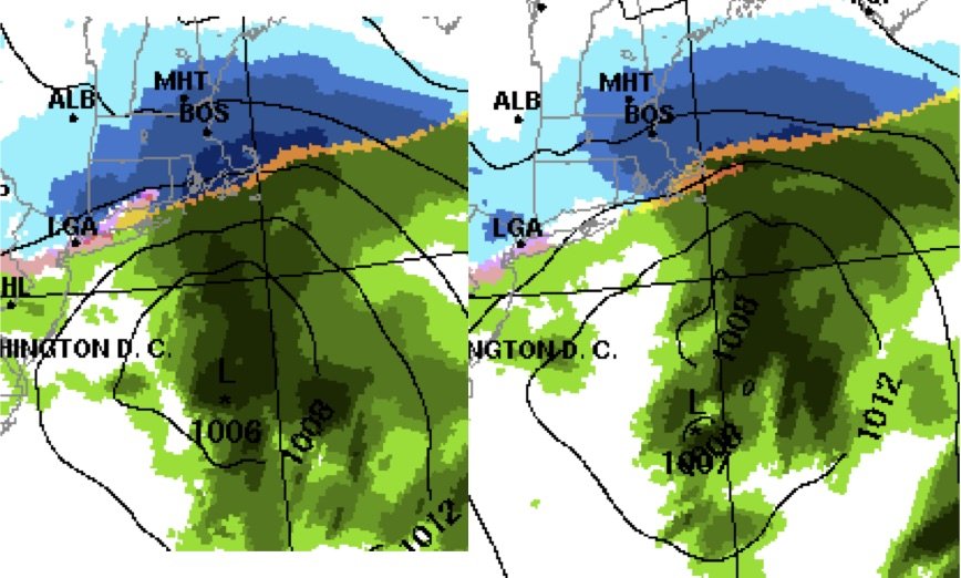
4 minutes ago, ORH_wxman said:
Ukie 500/sfc....gonna have to wait a bit longer for the QPF queen maps. But I don't really think you need them....this is a big solution for eastern areas at minimum....and prob back into central SNE as well.
Wow, that looks great! I don;t want to speak too soon with the Euro still to come but what a difference 24 hrs makes! And this close in to boot!
-
10 minutes ago, Baroclinic Zone said:

Right or wrong, that is the most beautiful thing I've seen all winter
-
9 minutes ago, wxsniss said:
Love it

That will most certainly go up tomorrow if the GFS-like solutions keep coming.
Hopefully Harvey will be in tomorrow instead of weekend working wankum here
-
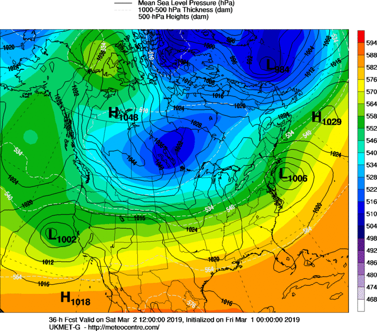
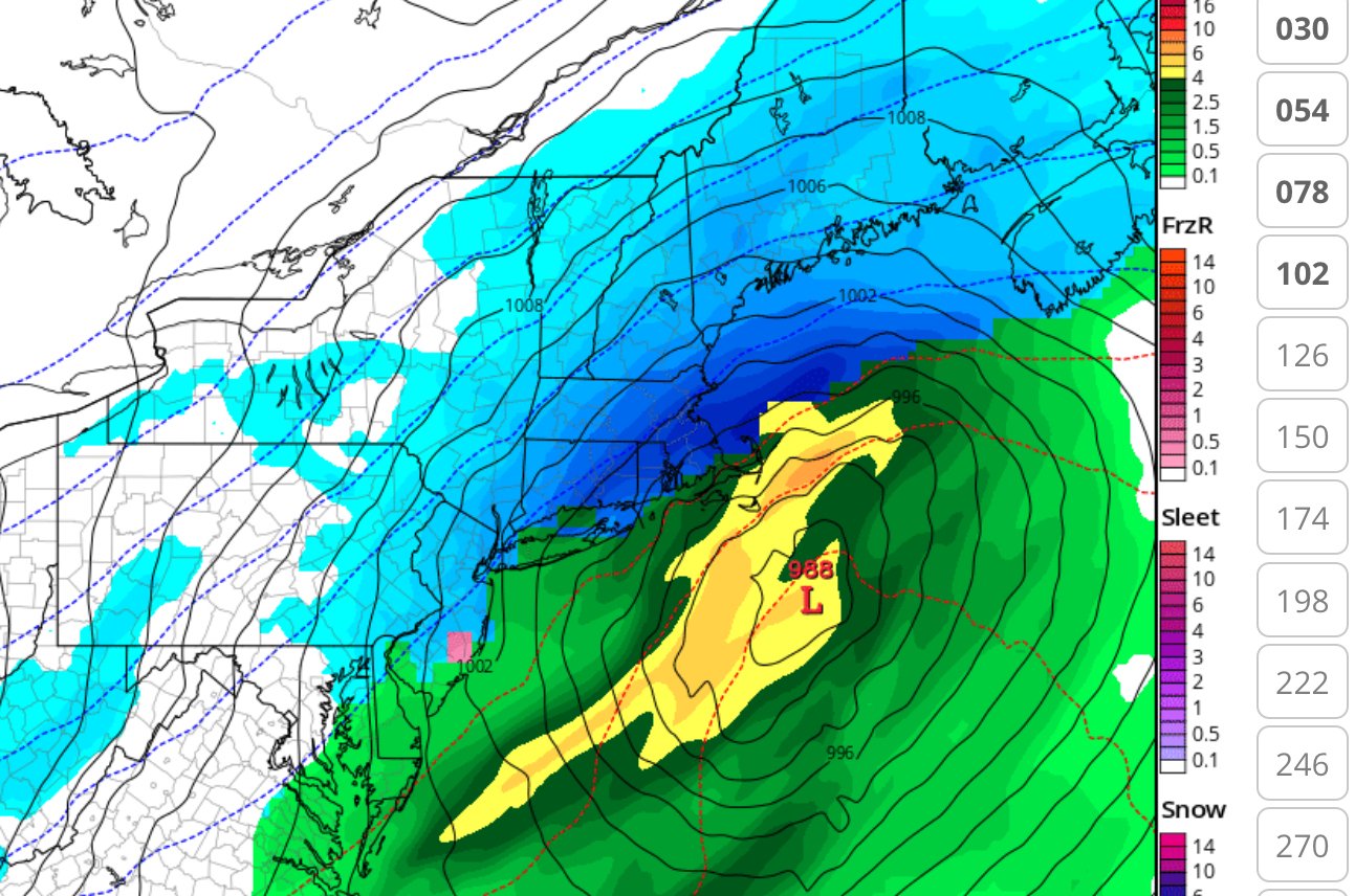
18 minutes ago, Baroclinic Zone said:
Geez, GFS FV3 is a nuke. 988mb near BM
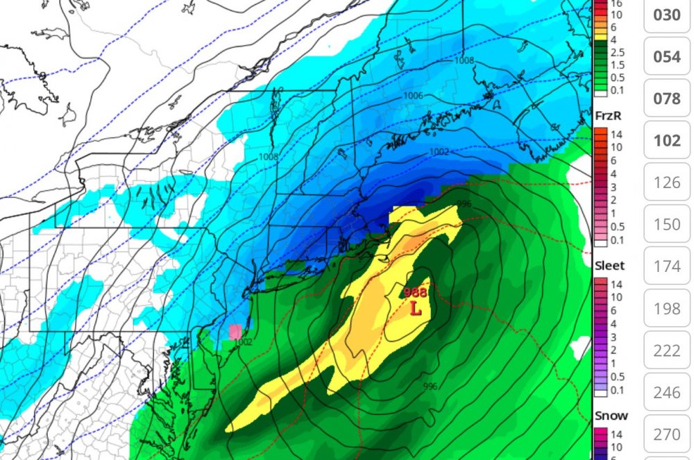
Wow, that's a beaut. Too bad it's this crappy new GFS and probably won't look like this come Monday.
I actually find it encouraging that the regular 00z GFS went SE being that the Euro is where it is. We'll see
-
2 minutes ago, USCAPEWEATHERAF said:
Really?? Wow. I am sorry it came out like that, but you would understand if your winter was close to as bad as mine.
It's the Cape man. It's just not a snowy climate compared to the rest of SNE. Now I'm not saying you're not going to possibly jack on this one but I wouldn't exactly be surprised if it rains at some point on the Cape either
-
Just now, wxeyeNH said:
Monday well south on the new GFS
Meaning the 00z run of the regular GFS or this silly FV3 GFS?
-
Just now, USCAPEWEATHERAF said:
Good, I wasn't sure I was clear enough.
Well, you only posted it like 3 times in 3 minutes. Came off as very childish and whiny to boot
-
2 minutes ago, USCAPEWEATHERAF said:
I don't want rain.
We know
-
14 minutes ago, snowman21 said:
Then what do you do when 12z ticks back the other way? Ryan already had 3-6 basically to the CT/RI border and said stay tuned because things were trending towards a bigger hit. As it stands now, he can just drag that 3-6 purple shading 40 miles westward over New London County.
This x1000. Basically would be changing maps based on one 18z suite. Then what do you do when things start going the other way for the 00z suite like they look like they're doing already
-
18 minutes ago, CoastalWx said:
The GEFS are statistically not as good as the EPS. This one is not for ern MA. Congrats NNE.
Thanks for the answer. I'm just gonna enjoy whatever Saturday brings us for now and worry about Sunday/Monday after even though you're probably right as that has been the track of the season to take, right over the Canal/Cape
-
1 hour ago, qg_omega said:
Best shot of snow is Friday night into Saturday morning for the coast. Monday is a rain storm. Basically I like the exact opposite of what you posted in terms of snow
Shocker!
-
 2
2
-
-
1 hour ago, CoastalWx said:
Sell GEFS
Really? Is that because they are just not as good as the EPS or not good at all? I would think that any ensembles would be the best approach but then again, every situation is different
-
3 minutes ago, 40/70 Benchmark said:
Its just never wise to do a 180 in one shift..
And jump to really high numbers, like many others have said on here
-
 1
1
-
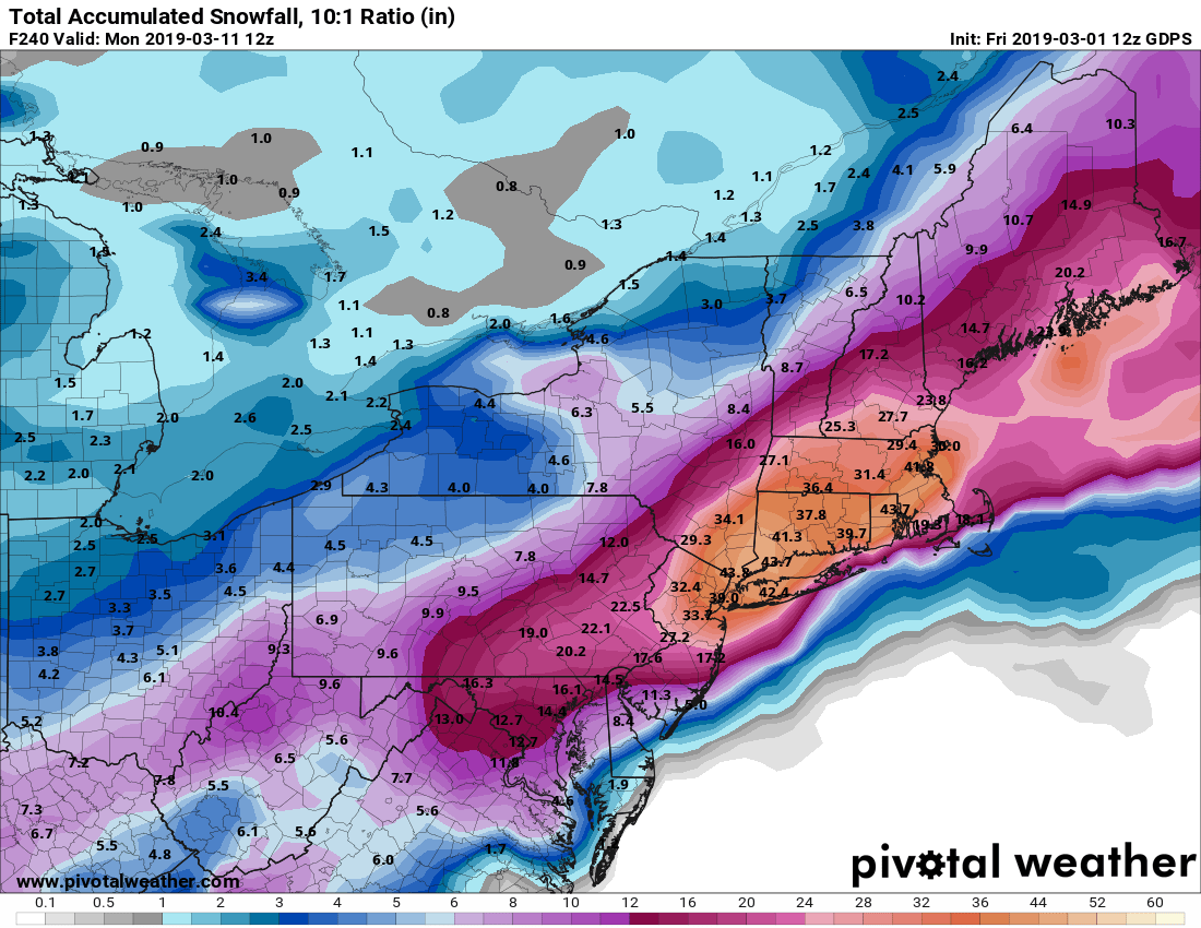


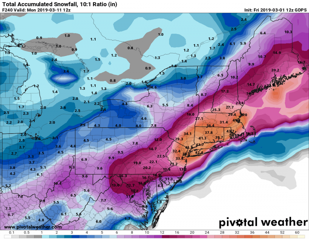
Perhaps a Coastal Storm on March 2nd for SNE????
in New England
Posted
Yeah at least it stops the East push. Maybe it goes back a little now. Glad I was wrong