

ILSNOW
-
Posts
1,433 -
Joined
-
Last visited
Content Type
Profiles
Blogs
Forums
American Weather
Media Demo
Store
Gallery
Posts posted by ILSNOW
-
-
Just now, Chicago Storm said:
0z GGEM came north. Tracks along IL/WI border.
and then there was 1 left. When will/if the Euro cave to every other model?
-
Baby steps

-
-
Just now, Chicago Storm said:
18z GEFS jumped north as well.

-
 1
1
-
-
question for the PROS what is the Euro seeing that the others arent or what are the others seeing that the Euro isnt?
And what time does the 18Z EURO come out?
-
 1
1
-
-
nope at 66 getting ready to go into west central wisconsin
-
Euro 72hr 998 SE IOWA
-
1 minute ago, mimillman said:
Thanks RC.
E3/E20 are how I see this eventually unfolding, favoring the IL/WI border.
and that is at 10:1 ratio so snowfall should be higher. Just trying to stay positive trends today have not been our friend.
-
1
-
-
9 minutes ago, RCNYILWX said:
Still pretty sizable spread on the GEFS. The operational model trends except for UKMET are what they are today, though not gonna punt this for northern IL. This synoptic setup is a tough one for the models to nail and some of the important features are in a data void area.


Sent from my SM-G965U using Tapatalk
To RCNY point above the 12Z operational GFS was north of the 6z but the 12Z GEFS is better than the 6z GEFS

-
2
-
-
-
yep 994 right over chicago at hr 78
-
you put much credence in most models moving north?
-
12Z NAM with a track thru southern Wisconsin
-
1
-
-
12Z GFS back south and is a crush job for Chicago area with wide spread 14-16 totals. I am sure it will fluctuate north and south over next few days.
-
2-3 inches of wet snow overnight
-
From LOT sounds aggressive to me
URGENT - WINTER WEATHER MESSAGE National Weather Service Chicago IL 859 PM CST Tue Jan 22 2019 ...Impacting Wintry Precipitation Through Wednesday Morning... ILZ006-231100- /O.CON.KLOT.WW.Y.0005.000000T0000Z-190123T1800Z/ Lake IL- Including the city of Waukegan 859 PM CST Tue Jan 22 2019 ...WINTER WEATHER ADVISORY REMAINS IN EFFECT UNTIL NOON CST WEDNESDAY... * WHAT...Snow, possibly mixing with rain overnight. Additional snow accumulations of 2 to 6 inches. * WHERE...Lake IL County. * WHEN...Until noon CST Wednesday. -
Buffalo Grove freezing rain side streets are a skating rink
-
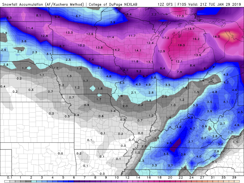
18Z GFS total run has to be one of the best of all time for southern Wisconsin with close to 35 inches of snow I know it won’t happen but that snow map is unbelievable!!!
-
2
-
-
-
I would think if trends were to continue that LOT would post a LE snow watch/warning for cook and Lake Co IN soon.
-
Recently from LOT

-
28 minutes ago, mimillman said:
Still no word from LOT on the lake effect this evening/tomorrow
you can see a LE band on radar starting around Milwaukee. You should do very well tonight!!!
-
9-10 inches here still snowing lightly
-
1
-
-
hope you are correct currently have steady light snow eyeballing 1 -1.5 inches if its going to snow at this rate overnight I think it is going to be tough to get there.

Hybrid Clipper Event 1/27-1/29
in Lakes/Ohio Valley
Posted
Approximately 2 hours till the fat lady sings.