

ILSNOW
-
Posts
1,433 -
Joined
-
Last visited
Content Type
Profiles
Blogs
Forums
American Weather
Media Demo
Store
Gallery
Posts posted by ILSNOW
-
-
portion of LOT update
Overall, there is some very impressive ingredients coming together
to support a 6 to 8 hour period of heavy snow across portions of
the area tonight. First and foremost, very strong isentropic
upglide is expected across the area overnight as around 50 kt
southwesterly winds develop orthogonal to the isobaric surfaces.
This will be complimented by some quiet impressive moisture, which
is noted by mixing ratios around 3.0 g/kg on the 280-290 theta
surfaces. It appears that periods of heavy snow overnight will
produce periods of 1 to perhaps 1.5 inches per hour, especially
over far northern IL. This timeframe looks to be roughly from
around midnight through 6 am Monday morning, when all of the
dynamics with this system will be coming together. This includes
what appears to be a strong band of 850-700 mb frontogenesis
setting up across southern WI and into far northern IL during the
overnight hours. Given that this will coincide with the timing of
the best larger scale forcing for ascent from the parent mid-
level impulse periods of heavy snow will be likely. Blowing snow
is also expected overnight as south winds increase and becoming
gusty. This will likely add to reduced visibilities in the heavy
snow.
-
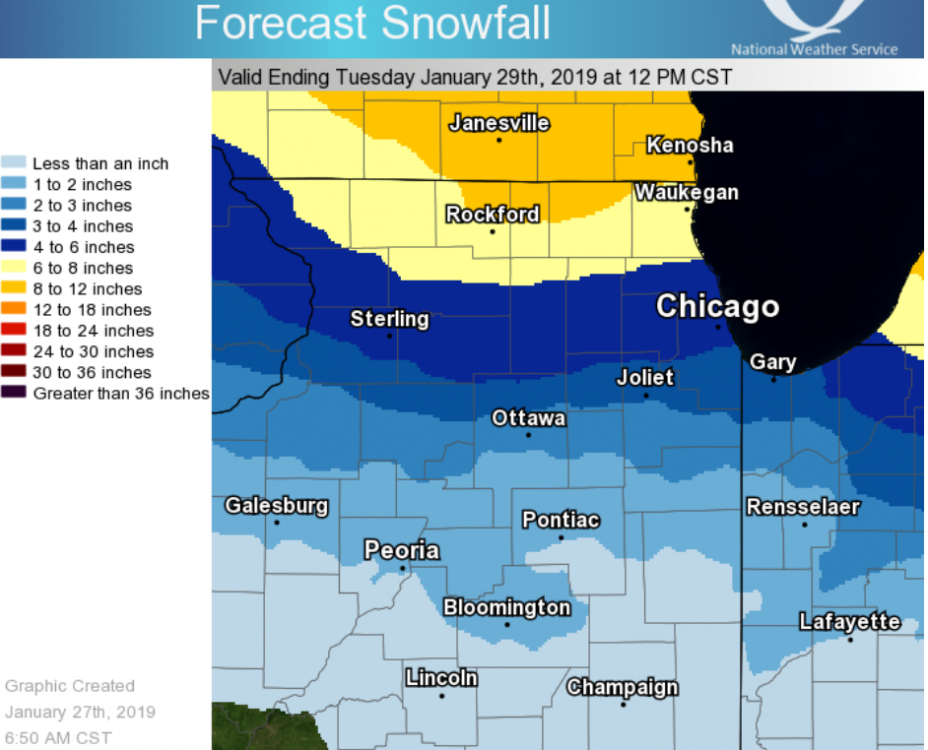
new LOT map
gets rockford and waukegan into the 8-12 range
gets the 6-8 range into cook co but still north of downtown

-
1 minute ago, SchaumburgStormer said:
More a DVN to RFD to MKE track.
I was calling this Waukegan

-
great run for SE WISC up to milwaukee as low heads NE from DVN to over Waukegan
the ultimate pivot timing from a SE to NW movement is going to be huge!!!
-
MKE update
National Weather Service Milwaukee/Sullivan WI
1200 PM CST Sun Jan 27 2019

.UPDATE...
Most of the 12z suite of model output is available. The biggest
differences of note are the RAP/HRRR/ARW/NMM being northern
outliers with the surface low track (across southern WI), while
the NAM/GFS/GEM/00z ECMWF move the low across northern Illinois.
Always challenging to have such differences this close to the
event, but the do dictate where the heaviest band of snow will set
up. Ensemble means still ride the state line at this point. Will
continue to update QPF/Snow totals early this afternoon with
updates out shortly thereafter.

&&

.AVIATION(18Z TAFS)...
Major winter storm will affect the region tonight and Monday. No
major changes to snow start time, beginning roughly 01-03 UTC over
western portions of the area (MSN) and 03-05 UTC over the eastern
half of the area (UES/MKE/ENW). One to two inch per hour snowfall
rates are possible late this evening through the overnight hours.
Biggest change to the forecast was to keep snow longer during the
morning hours, ending by mid afternoon. More tweaks to the end
timing are likely. Expect IFR/LIFR with the heavy snow overnight,
gradually improving late Monday morning and afternoon.
-
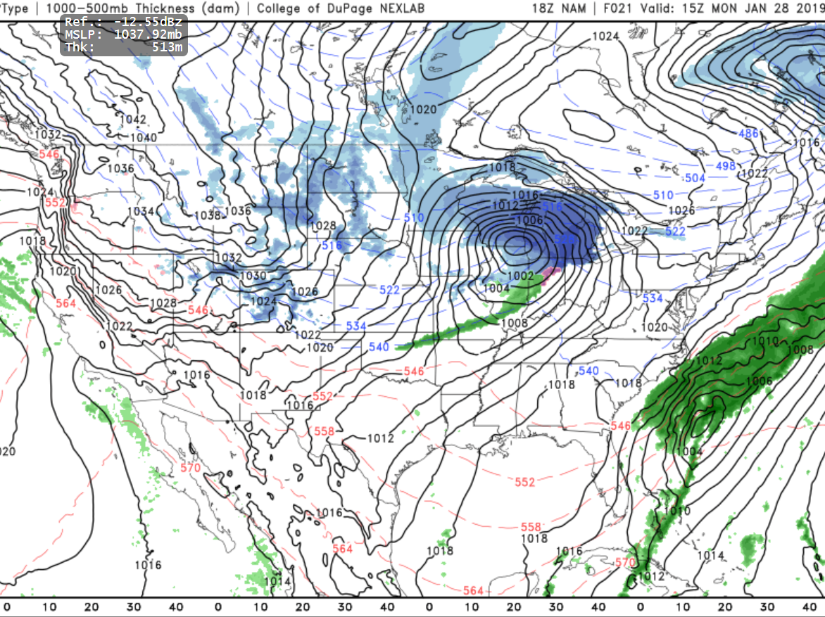
looks like 997 over Quad cities at 24 hrs
-
Just now, Hoosier said:
Maybe it's tracking fatigue but outside of a rogue run or two, I don't remember the surface low track being shown that far north. Consensus on southern WI/northern IL has been pretty solid for a while.
I agree however the models are taking the low farther south in Iowa before hooking and existing IL near Waukegan
-
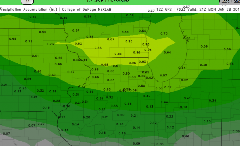
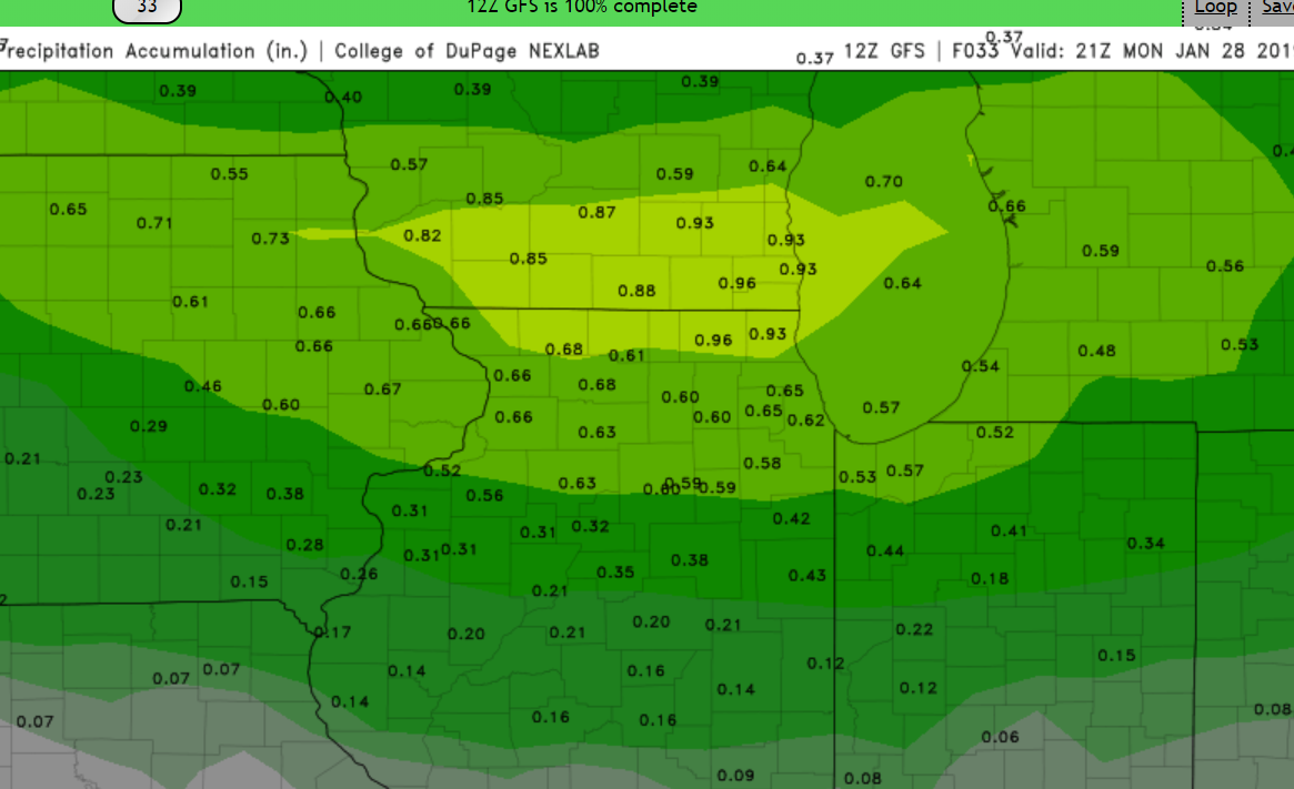
12Z GFS precip totals
-
-
latest from LOT
-
LOT update
While Sunday will remain cold, with daytime highs in the teens,
temperatures should be on a warming trend Sunday night as
southern winds become gusty in advance of our next clipper system.
Unfortunately this warming will come at the cost of more moisture
and the development of snow over the area. This fast moving and
potent clipper system will be tracking somewhere right across far
northern IL around the WI stateline on Monday morning. It looks to
be ahead of the main surface low that northern IL and portions of
northwestern IN could see a period of heavy snow. Timing wise
this would be roughly be from mid-late Sunday evening through mid-
morning Monday. During this period strong isentropic upglide will
set up across the area as 35 to 50 kt winds develop on the 280
through 290 surfaces are run directly perpendicular to the
isobars. This, in addition with increasing large scale forcing
for ascent from the approaching mid-level impulse, should result
in good ascent supportive of snow development over the area. It
also appears that some periods of quiet heavy snow will also be
likely, especially across far northern IL Sunday night, this as
mid-level lapse rates look to steepen considerably (700-500 mb
lapse rates of 6.5C+ per KM) in response to the strong lower-level
warm air advection.

With all this in mind, in spite of the track of the low, we could
still end up with amounts exceeding 6+ inches over far northern
IL, with likely lesser amounts south of the watch. Again a
majority of this would fall overnight Sunday into early Monday
morning. During the morning Monday, a mid-level dry slot looks to
shift in over the area. Once this occurs, we will likely see the
precipitation eighter end, or switch over to some
drizzle/freezing drizzle. Surface temperatures may briefly warm
to, or just above freezing Monday morning, but this will be short
lived as cold air spills back across the area Monday afternoon.
There could be some lingering light snow Monday afternoon, but any
additional accumulations look to remain under an inch.

At this time we plan on holding with the winter storm watch for
the northern tier of counties. This may need to be upgraded to a
warning tonight. South of the watch, it appears snowfall amounts
will generally be in the 3 to 6 inch range down to around the I-80
corridor, A winter weather advisory may be needed south of the
current watch down towards the I-80 corridor. These areas could
need a winter weather advisory in the future. South of I-80 it
appears that snow amounts will fall off into the 1 to 3 inch
range.
-
Euro 48 hrs 997 Eastern Iowa/NW Illinois
-
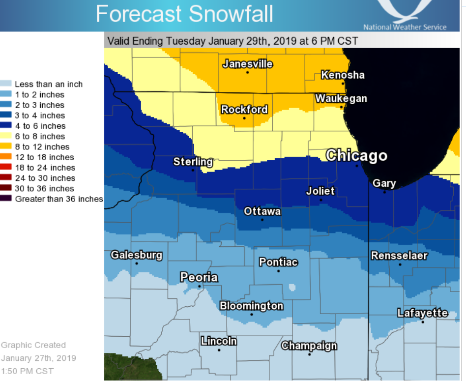
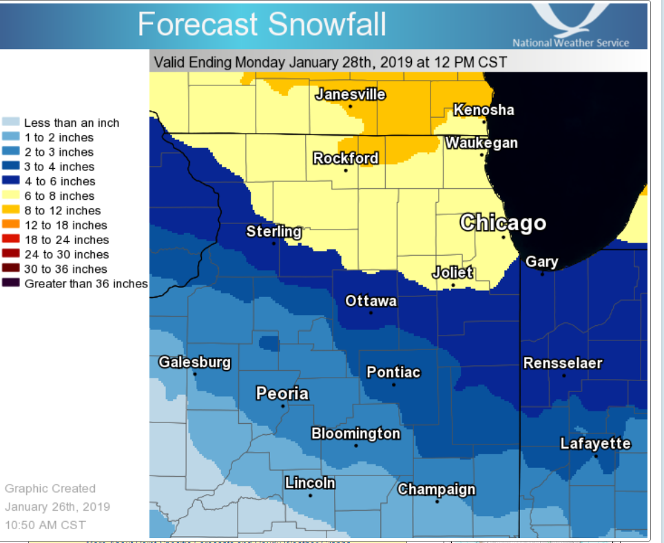
latest LOT map to Hoosiers point I am not sure that this includes the 1-3 for today but does bring the 6-8 inch area down thru chicago and joliet.

-
 2
2
-
-
National Weather Service Chicago/Romeoville, IL
1022 AM CST Sat Jan 26 2019

.UPDATE...
1022 AM CST

Updated POPs and snow amounts to increase them this afternoon into
this evening. Overall, it is looking like as good, or even a
slightly better setup then Friday`s event for light snow over the
area today. For this reason, we have bumped up POPs significantly,
and upped snow amounts into the 1 to 3 inch range, especially
south of I-88 and I-290, with up to an inch north. The snow should
end across the area by mid evening.
-
And another thing to consider while we have the NAM and the GFS with the low into Southern Wisc we have the Euro (granted alone) into northern IL. who do we trust at this range?
-
4 minutes ago, Baum said:
I would not be surprised to see the precip/snow wrap all the way back around the low center. To me, despite it's northerly track it still will have the ability to put some snow down fairly far south of the main storm on the arctic front. Seen this before. Quick 2-4" hit with strong winds,blowing snow, and rapidly falling temps. I'm certainly not a met., but do rely on my memory and history of prior events when I see certain set ups.
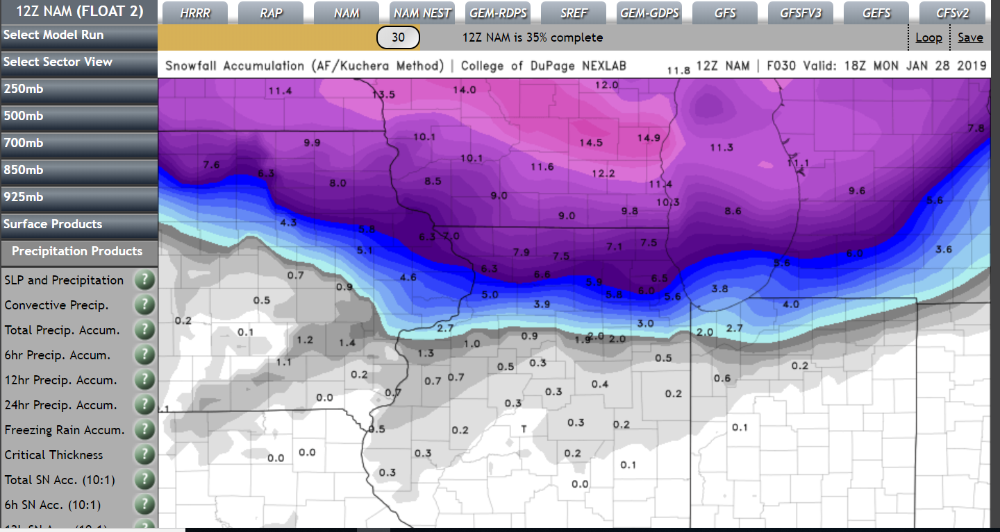
and the 3km Nam tries to do just that after getting dry sloted at hr 51 it the backside fills in with snow from hr 54-60
-
1 minute ago, Chicago Storm said:

.Thanks to bad it is on its own.
-
Just now, ChiTownSnow said:
Unfortunately, it won't be that cold
yes it will
my local forecast for sunday and sunday night
SundayPartly sunny, with a high near 12. Wind chill values as low as -14. West northwest wind around 5 mph becoming south in the afternoon.Sunday NightSnow, mainly after 9pm. The snow could be heavy at times. Patchy blowing snow after midnight. Low around 11. South southeast wind 5 to 10 mph increasing to 10 to 15 mph after midnight. Winds could gust as high as 30 mph. Chance of precipitation is 90%. New snow accumulation of 3 to 7 inches possible. -
Just now, Chicago Storm said:
6z ECMWF held with a track across far N. Illinois.
.can you share snow amounts for IL northern counties?
-
LOT snow map

-
72 hours 1003 eastern indiana/western ohio
-
 1
1
-
-
nope SD/Nebraska
-
euro 48 hrs 997 SD/Nebraska border
-
 1
1
-
-
3 minutes ago, ChiTownSnow said:
You guys are all crazy.. Even with the SLP tracking north, still a decent amount of snow for many on here. Usually we all be happy for 4+ snow potential
you are correctly the 0Z GFS spits out .42 precip for ORD I would think we should still have a 4-6 inch event as it currently stands. However if the clear trend north persists that aint happening. It would be awesome of the Euro could stay steady in here but everything today execept the 0Z NAM has been NORTH!!
We will see when then Euro comes out.

Hybrid Clipper Event 1/27-1/29
in Lakes/Ohio Valley
Posted
agree 100% appears all think that the 12Z gfs was overdone.
to me important thing to take away is that all models have taken the low further south in Iowa but where this thing pivots NE is going to be huge!!!
Chicago storm or other PROS what causes the sudden NE movement and do you buy it?