DownS.EasternVa
-
Posts
52 -
Joined
-
Last visited
Content Type
Profiles
Blogs
Forums
American Weather
Media Demo
Store
Gallery
Everything posted by DownS.EasternVa
-
Richmond Metro/Hampton Roads Area Discussion
DownS.EasternVa replied to RIC Airport's topic in Mid Atlantic
Roads are caving fast -
Richmond Metro/Hampton Roads Area Discussion
DownS.EasternVa replied to RIC Airport's topic in Mid Atlantic
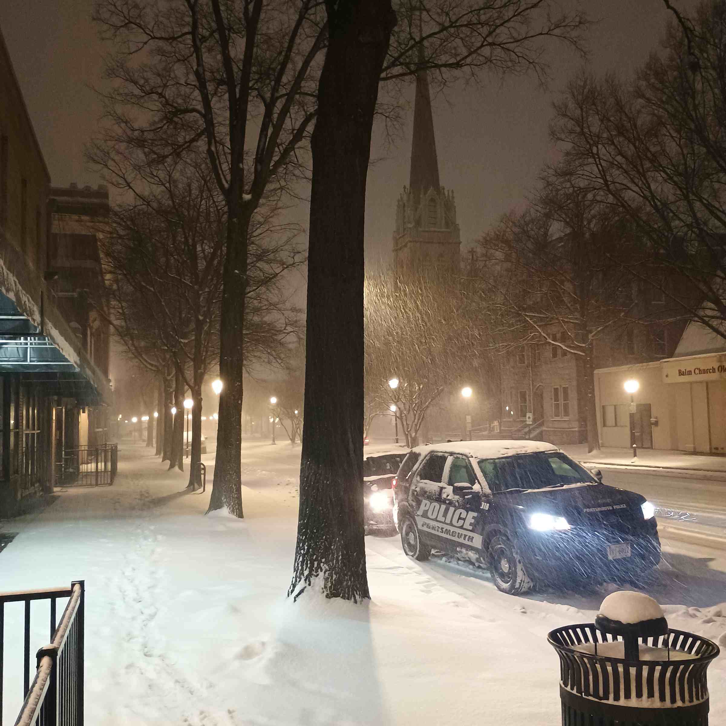
It's pouring the grass is white, Portsmouth Probably the heaviest snow I've ever seen -
Richmond Metro/Hampton Roads Area Discussion
DownS.EasternVa replied to RIC Airport's topic in Mid Atlantic
Snowing pretty hard very quick dusting on cars and grill -
Richmond Metro/Hampton Roads Area Discussion
DownS.EasternVa replied to RIC Airport's topic in Mid Atlantic
Portsmouth about 75-85 % snow now -
Richmond Metro/Hampton Roads Area Discussion
DownS.EasternVa replied to RIC Airport's topic in Mid Atlantic
Mixing starting in Portsmouth -
Richmond Metro/Hampton Roads Area Discussion
DownS.EasternVa replied to RIC Airport's topic in Mid Atlantic
0z Nam just dropped 6 inches this thing has legs... Lol -
Richmond Metro/Hampton Roads Area Discussion
DownS.EasternVa replied to RIC Airport's topic in Mid Atlantic
I believe in this system, no sensationalized Facebook & Instagram post. Not on anyone's radar, trending better as we get closer. I'm thinking HR biggest snow..... Seriously -
Richmond Metro/Hampton Roads Area Discussion
DownS.EasternVa replied to RIC Airport's topic in Mid Atlantic
I think you guys will be seeing flakes soon it's a nice band setting up over the peninsula -
Richmond Metro/Hampton Roads Area Discussion
DownS.EasternVa replied to RIC Airport's topic in Mid Atlantic
Starting to light snow in Portsmouth, winds are howling -
Richmond Metro/Hampton Roads Area Discussion
DownS.EasternVa replied to RIC Airport's topic in Mid Atlantic
Winter Weather Advisory Back up for Hampton Roads outside VB Freezing Rain... Is falling in Portsmouth as well -
Richmond Metro/Hampton Roads Area Discussion
DownS.EasternVa replied to RIC Airport's topic in Mid Atlantic
Yeah I think this could be a pretty cool event, thunder sleet or thunder graupel isn't something you get often. -
Richmond Metro/Hampton Roads Area Discussion
DownS.EasternVa replied to RIC Airport's topic in Mid Atlantic
Too bad all our snow got washed away, but it seems as though the 2nd round of precip is trending colder for Hampton Roads. My temps in Portsmouth have dropped from 41 to 35, since winds have flipped. The HRRR now has sleet or freezing rain pushing back into Norfolk, and the 12z GFS also have a small amount of measurable frozen precip fall between 7p-1a. Maybe I'm just wish-casting at this point but maybe something interesting.... -
Richmond Metro/Hampton Roads Area Discussion
DownS.EasternVa replied to RIC Airport's topic in Mid Atlantic
Sleet in Portsmouth -
Richmond Metro/Hampton Roads Area Discussion
DownS.EasternVa replied to RIC Airport's topic in Mid Atlantic
Heavy snow on the Southside of Hampton Roads, Portsmouth closing in on an inch. Radar returns look very good -
Richmond Metro/Hampton Roads Area Discussion
DownS.EasternVa replied to RIC Airport's topic in Mid Atlantic
Portsmouth was forecast to be 29, we hit 23. It's pretty cold also, seen light flurries on 64 between Richmond and Williamsburg. -
Richmond Metro/Hampton Roads Area Discussion
DownS.EasternVa replied to RIC Airport's topic in Mid Atlantic
-
Richmond Metro/Hampton Roads Area Discussion
DownS.EasternVa replied to RIC Airport's topic in Mid Atlantic
Yeah Portsmouth Va is ALL SNOW absolutely ripping pushing 5 maybe 5.5 inches. -
Portsmouth, Va absolutely pouring ALL SNOW closing in on 5 inch probably.
-
Richmond Metro/Hampton Roads Area Discussion
DownS.EasternVa replied to RIC Airport's topic in Mid Atlantic
Nice band moving North toward Northern half of S.Hampton Roads should pick up accumulation fast. -
Richmond Metro/Hampton Roads Area Discussion
DownS.EasternVa replied to RIC Airport's topic in Mid Atlantic
That's just the way things go in Hampton Roads sometimes, it is always great to see it come down. With that said HR usually never score big on the 1st snow of the season, just an observation from being here my whole life. It is encouraging to get snow early on though, and we usually pull a rabbit or 2 out the hat when it's especially cold on the east coast. Overrunning system are always tricky around here too, the warm nose is always on the table with those set ups, even when it's 28 degrees unfortunately. We never get good snow if both Richmond and NOVA are receiving anything (sorry not sorry) even 1 in amounts. Another observation for HR peeps on overrunning events, always look to Raleigh, 10 out of 10 if Raleigh is have mixing issues we're having mixing issues. Storms got to be way south, Wilmington,Charleston area for good overrunning event around here. With that said 12z guidance is pretty intriguing for HR, pressing artic cold and Miller A's are our wheelhouse. -
Richmond Metro/Hampton Roads Area Discussion
DownS.EasternVa replied to RIC Airport's topic in Mid Atlantic
GFS trending colder for Hampton Roads as well, 32-33 the entire event. -
Richmond Metro/Hampton Roads Area Discussion
DownS.EasternVa replied to RIC Airport's topic in Mid Atlantic
GFS just dropped a bomb on all of Eastern VA -
It'll torch, at the wrong time as usual. Like late December thru mid-March. Then we'll have a pseudo winter in Spring that delays the good spring days. Been this way for about a decade now SMH.
-
Potential 1/28-1/30 2022 winter storm
DownS.EasternVa replied to Prismshine Productions's topic in Southeastern States
Sleeting in SE VA -
Richmond Metro/Hampton Roads Discussion
DownS.EasternVa replied to RIC Airport's topic in Mid Atlantic
Not much virga in this area