

Jed33
-
Posts
1,005 -
Joined
-
Last visited
Content Type
Profiles
Blogs
Forums
American Weather
Media Demo
Store
Gallery
Posts posted by Jed33
-
-
Light snow currently falling. Looks like the rooftops are whitening up a little.
-
It’s actually mixing a little here too now.
Edit:Full on graupel/snow shower now. Wasn’t really expecting that this morning
-
 1
1
-
-
-
Moderate snow again here now. Flake size has increased again.
-
1
-
-
Got about 1/2in now even seeing it stick to a few roads and sidewalks
-
3
-
-
Man it’s really coming down here to everything getting white fast!
-
4
-
-
There is some pixie dust here so far this AM, but it’s so light it’s just blowing right off.
Edit: Flake size is actually a little better now and I can begin to see a very light dusting on cars-
1
-
-
Yeah this system is way bigger than what most, if not all models had indicated
-
4
-
-
Well I think the answer to the thread title turns out to be right! It will. That is a wall of snow entering the state of Mississippi down almost the entire western side of the state.

-
4
-
 1
1
-
-
JAN has a very detailed afd this AM about the system. Mentions that this is a non traditional setup for snow with the Sfc low in the gulf and the upper and mid level lows displaced to the north. This is “throwing off” as they say, many of the normal winter storm conceptual models. The afd goes on to talk about a lot of the other unusual things related to this system. Worth a read, even if it doesn’t impact your area, as there is a lot of interesting wording there.
-
2
-
-
Don’t look now, but the RGEM at 0z is trying to stretch the snow NE even into E TN now. Light event, but at 18z it didn’t have that. Used to be, when you’d see these depictions like this, you’d know that it would move into NE MS northeastward through N AL and into E TN. So, I’ve kept this in the back of my mind so far and wondered about it. Now, it may have been a fluke run, as nothing else really shows that much frozen. However, I think the euro and NAM, to a degree have been toying with that idea. So, for what it’s worth, here’s the 0z RGEM.

-
3
-
-
That band up around Kingsport looks like it has unloaded pretty good. @Carvers Gapyou get anything from it?
-
1
-
-
Snowfall has varied wildly around here. I had between 1/2-1in earlier, but it’s melted down a little now. Meanwhile, there are places on the SE side of the county that have bare grass!
-
Approaching 1/2in on the grass now. It whitened up in a hurry for sure!
-
1
-
-
I just woke up, bc you know I couldn’t sleep haha! Anyway, we have nice big fatties coming down. Temp is 32. Now a nice dusting forming on the grass cars, etc.
-
Got some sleet mixing in with the rain. Maybe a flake or two.
-
My old stomping grounds literally! That is right where our family farm is. Too bad the highest hills in that area are just barely over 500 ft.
Edit: Talking about the radar image from NE MS. Not the plateau. -
2 minutes ago, TellicoWx said:
Even the GFS upgrade says the old system is lost
Yeah it’s really bad, but the regular gfs finally started to come around a little at least for NE TN down to just NE of Knoxville at 12z

-
1
-
-
31 minutes ago, Holston_River_Rambler said:
Looks pretty on NT Microphysics GOES 16 imagery:
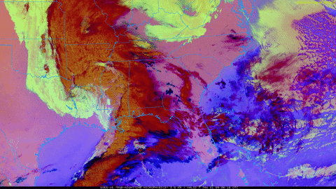
I am a fan of the low level NE flow evident over WV and KY
It’s always good to have a NE flow when your looking for snow! At least it seems to be.
-
3 minutes ago, John1122 said:
The GFS will probably shift back West some like the NAM did. Though it may wait until tomorrow.
Knowing the GFS, it probably won’t find it tonight. For the Christmas storm, it literally took it till the day before, before it began to understand what was going to happen. Really it was 12z the day of the event before it fully caught on. That model struggles so bad these days!
-
2
-
-
RGEM also coming back some from 18z. Looks better for NE TN. Also better for the plateau and some other areas of eastern Middle TN

-
9 minutes ago, TellicoWx said:
Still snowing across NE TN at 66..already closing in on 12" at MRX
I’ll take it haha!
-
Looks like we have been at or below freezing since about 4:30 Thursday afternoon. Today should warm up into the 40’s, so it will end the streak of freezing or below freezing temps. I’ll have to look back, but I’m thinking it’s been since 2018-2019 since we had a stretch below freezing of that length or greater.
-
3
-
1
-
-
Bottomed out right now at 6 degrees here at the house. Looks like MRX is at 8. Definitely the coldest since 2018. We didn’t break into the single digits at all last year. The power of snow cover!
Edit: I said they were at 8 bc that’s what the current observation was around the time I wrote it. I guess they went with 9 instead.

-
3
-

Jan 2021 Squallicane
in Tennessee Valley
Posted
Have a solid dusting on rooftops, cars, and grass. Temp is doing a similar thing here and I wonder if it may be due to the dewpoint increasing as moisture moves in. That in turn is increasing the temperature. Then when the moisture moves out, the dewpoint falls back a degree and temp goes down. For instance, when it was snowing a few min ago, I was at 30 degrees with a dp between 29/30. Now that it’s stopped, I’m at 29 dp 28. Just a thought