

snowbird1230
-
Posts
454 -
Joined
-
Last visited
Content Type
Profiles
Blogs
Forums
American Weather
Media Demo
Store
Gallery
Posts posted by snowbird1230
-
-
Hurricane
-
 1
1
-
-
Much less snow coverage than 18z
-
Totals seem off at the surface..
-
Mercy at the NAM.
-
1
-
-
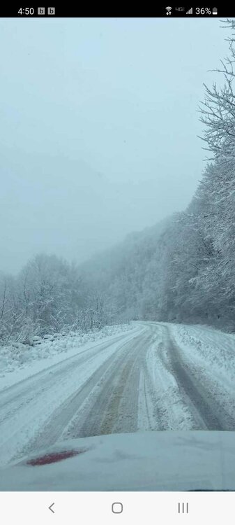
Getting reports of many vehicles stranded on Cherohala Skyway..16" of snow..50 mph winds
-
4
-
-
Cherohala Skyway 15"
-
6
-
 1
1
-
-
1-2" throughout Graham County but massive dry slot fixing to work in
-
Welp 12z Euro and GFS both with a foot for me but my NWS forecast is 100% chance of rain. Anyone else seeing goofy things like that?
-
Boyer just updated totals.
Marshall 1"
Waynesville 5"
Everyone west of the Balsams 1-4"
Most of the higher totals are East of Asheville and around Cashier's and Toxaway
-
 1
1
-
-
If any of you guys follow DT / WXRISK on Facebook or Twitter..He's saying short range models are very concerning, coming in much warmer. States the possibility of a lot more Ice and much less snow in all of WNC
-
 1
1
-
 1
1
-
-
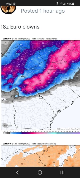
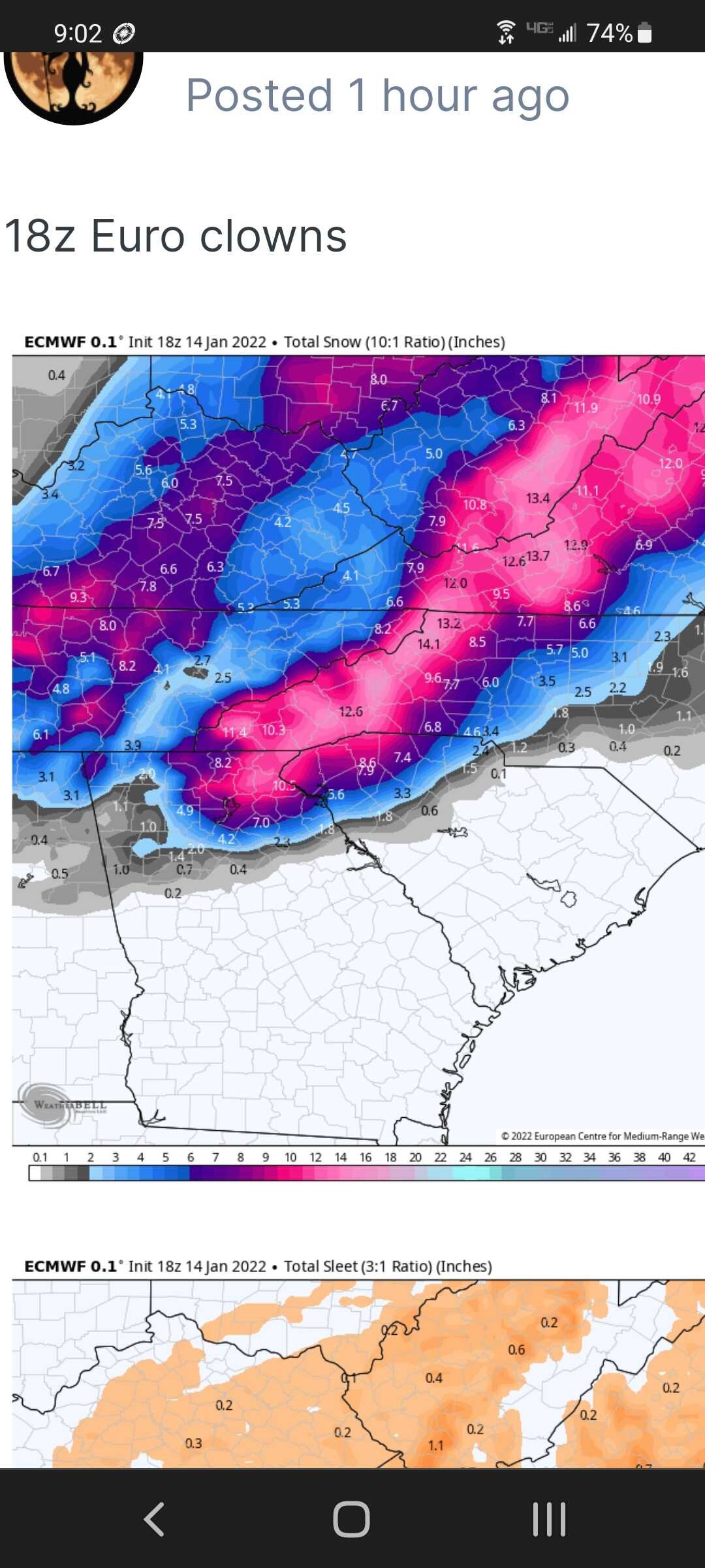
Can someone knowledgeable to the situation help me understand this forecast? This is the 18z Euro. I'm in Graham County , well into the 12"+ shaded area. Yet NWS is only giving me 1/2"- 1" the entire event.. Not understanding all I need to know.
-
1
-
-
41 minutes ago, Met1985 said:
NWS only looking at 5 to 11 inches for around my area but im not worried. Shoot ill take a few inches and be good
Enjoy Met.. Graham County under the warning also but then the forecast only gives us 1/2" of snow the entire event.
Snowbird out..
-
2
-
-
GSP upgrading to Warnings
-
2 minutes ago, BretWx said:
10:1 looks even better but...


Will 10:1 be more accurate with this storm?
-
The dreaded dry slot
-
3 minutes ago, wncsnow said:
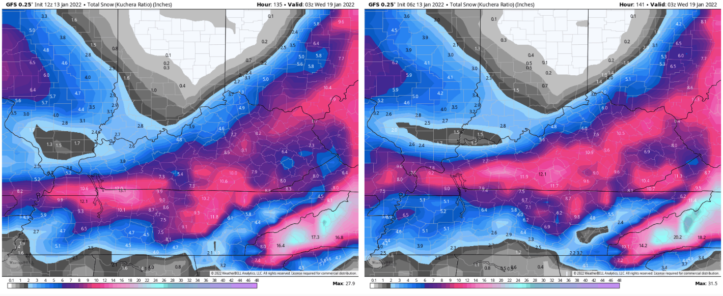
NAm crushes everyone
Except The Smokies, Graham,Swain and Cherokee counties
-
1
-
-
10 minutes ago, MattPetrulli said:
No longer a Sevier County exclusive snowhole, I would accept 4-6 inches.

Tellico's gonna like that map!!
-
3
-
-
Wow looks like Bryson City and Robbbinsville is out of the game..
-
Now heading south
-
Nam wayyyy North
-
3 minutes ago, Carvers Gap said:
Looks very much like the Euro.
I think you posted 2 GFS runs bud.
-
13 minutes ago, franklin NCwx said:
Hopefully the gfs calmed some nerves
Not mine!! Continually shows Graham County getting the shaft!! Lol
-
1 minute ago, BlueRidgeFolklore said:
CAD is almost always underdone at this range. As Ward and others have said, this will likely get corrected as we get closer.
Hopefully, RGEM sucked..rain in the mountains
-
Surface not verifying huge snow totals?
Mid to Long Range Discussion ~ 2022
in Southeastern States
Posted
NW trend definitely