

snowbird1230
-
Posts
484 -
Joined
-
Last visited
Content Type
Profiles
Blogs
Forums
American Weather
Media Demo
Store
Gallery
Posts posted by snowbird1230
-
-
3 hours ago, CheoahBald1 said:
Snowing in Graham county
.Just under 2" now
-
 4
4
-
-
1 minute ago, StantonParkHoya said:
NWS are not tv Mets. Important distinction.
True, what I was meaning is some tv meteorologist don't interpret the models well at all.
-
34 minutes ago, StantonParkHoya said:
Why do people care what TV mets say? They’re looking at the same models we are
Ive saw literally every model out there show huge amounts of snow in the mountains 24hrs before the event, yet when NWS GSP meteorologist look at them and cut the totals 60-70%..
90% of the time they are right.
Lots to interpreting models other than just looking at them
-
5
-
 1
1
-
-
19 minutes ago, wncsnow said:
.png.df622246fff38f202e3399c4a9bc3be5.thumb.png.08286ee2db4f2cbaa7a685f42adb919c.png)
Thanks but his is Weather Bell..Tennessee forum is talking that for some reason, Tropical, Pivotal , WB all showing different amounts
-
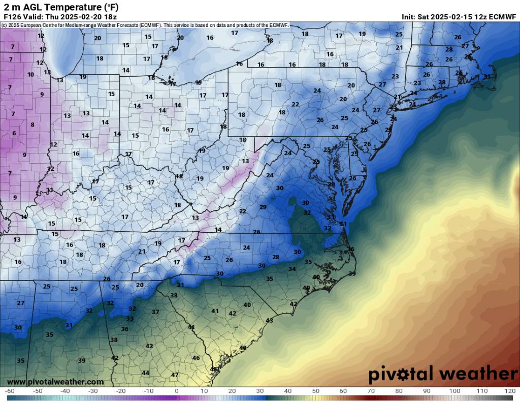
48 minutes ago, HKY_WX said:
18z Euro with a cool 2' in Richmond. I need that to trend 2 counties southwest lol.

Do u have this map for the entire state?
-
10 minutes ago, Met1985 said:
The temps preceding the storm are going to be very cold. I think even colder than what is being shown. If we get the snow we will easily see temps below zero.

.thumb.jpg.e96b75b32d1ca14a8a9b38ebfd7e1b6f.jpg)
Sent from my SM-G998U using Tapatalk
Hows the NWFS looking after the storm Met?
-
1
-
-
53 minutes ago, John1122 said:
Did MRX really say that surfaces are too warm for anything but grassy accumulations because of the last two days? It was 12 degrees yesterday morning and 19 this morning. I still have snow on the ground and sides of the road in shady spots.
I had to drive a golf tee in the ground with a hammer earlier today..thats the most ridiculous statement I've heard..ground very much frozen
-
3
-
-
Roads in Graham County were all covered around 3pm and still snowing
-
5
-
-
3 hours ago, Brick Tamland said:
It's really useless to trust anything with the models beyond 3 days. And if that's the case what is the point of looking at the long range models and discussing things on a forum like this? It's like daydreaming about what you would do if you won the lottery.
True..and really, what good are the ensembles? They change every run also ,so pretty tired of people screaming ensembles...
-
1
-
2
-
-
16 minutes ago, senc30 said:
I'm in Jacksonville. If no snow means avoiding ice and freezing rain, I'm fine with that. That Thursday evening/night forecast for us isn't anything I want.
Do I know u lol?
-
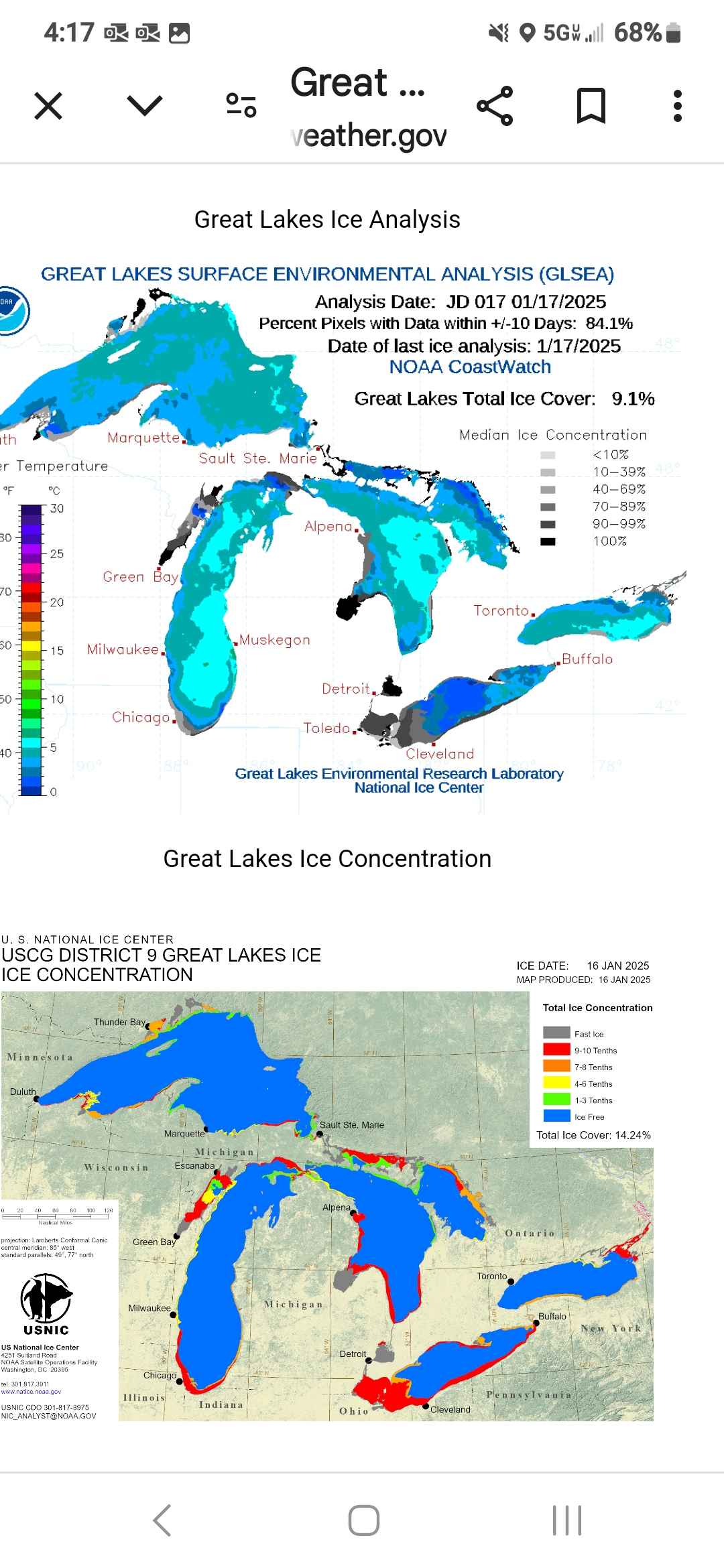
1 hour ago, StantonParkHoya said:
How are the Great Lakes unfrozen? It’s been the coldest January in 20 years
See graphic Stan. Definitely unfrozen and definitely a connection. We are under Warnings in Graham Co tomorrow for 10" of snow from NWFS

-
1
-
-
On 1/16/2025 at 11:45 AM, snowbird1230 said:
Should be more NWFS popping up next week..bitter nw winds coming over the UNFROZEN Great Lakes.
Bump. Lol
-
3
-
-
Should be more NWFS popping up next week..bitter nw winds coming over the UNFROZEN Great Lakes.
-
2
-
-
Major changes? Will Brick jump off the cliff?
-
1
-
 2
2
-
-
26 minutes ago, Met1985 said:
It's hammering the snow again now. Just puking.
Same in Graham Co!
-
2
-
-
3 minutes ago, jtgus said:
Graham, as in Alamance Co? I'm in Gibsonville and not even close to that amount!
Na man ,Mountain thread..Graham Co.!!
-
3
-
-
2.5 inches in Graham, sleet mixing in..pretty uneventful so far
-
3
-
-
36 minutes ago, Met1985 said:
This is back filling.
Sent from my SM-G998U using Tapatalk
Good catch
-
2
-
-
Snow has stopped in Graham Co...we need saturation fast..this ain't good
-
Snow in Graham Co
-
3
-
-
Did I misread the GSP AFD?
They mentioned NO other model except the NAM?
And that's the horse their gonna ride.
-
3
-
-
18 minutes ago, WxKnurd said:
That’s a SW Special there. Wayah, the Cowee’s, Snowbirds and Cheoahs would all be smoked! @snowbird1230will have some great skyway pics!
Actually getting a good snow shower now! I'm glad there's sanity in this thread!
-
5
-
-
3 minutes ago, BretWx said:
18Z GFS has snow starting to move into the area by 10AM Friday.
And alot of it.....
-
1
-
-
42 minutes ago, franklin NCwx said:
Congrats hayesville!
And Topton!
-
1
-
.png.df622246fff38f202e3399c4a9bc3be5.png.016a43ce9c17a6aa53546f72d8ebdf48.png)
.jpg.c2770c9159210fc08fc9ebbfa8406fd3.jpg)
February 19-20 Major Winter Storm Threat
in Southeastern States
Posted
Horrible map..4-6" for Graham Co lol