
WxBlue
-
Posts
2,718 -
Joined
-
Last visited
Content Type
Profiles
Blogs
Forums
American Weather
Media Demo
Store
Gallery
Posts posted by WxBlue
-
-
6 minutes ago, Baroclinic Zone said:
Tropical in origin but looks baroclinic.
That's an important clarification. Thanks. But yeah, it'd reach the baroclinic stage eventually moving up the coast. I'll admit I wasn't the sharpest student when I took my synoptic course two years ago.
-
52 minutes ago, WinterWolf said:
944 is monster storm....is it tropical in nature??? Or just an Autumn monster??
Looks baroclinic to me. It'll be gone by next run anyway.
-
 1
1
-
-
On 10/12/2018 at 3:39 PM, powderfreak said:
Foliage is done completely. Yesterday's rain did it in.
At least 50% sticks and the rest duller orange/yellow ready to fall off.
Yeah, it appear I mis-timed my visit to Stowe/Waterbury area to see a relative by 48 hours. That's pretty much what I saw up by the ski area. However, Richmond still had a nice show ongoing and the drive on VT-100 south of Waterbury was BEAUTIFUL. Will have to come back next year and try to take a day off in middle of week to deal with thinner crowd. And so I don't have to risk waiting until the weekend before rain/wind tear down the peak.
I also drove through US-2 and down I-93. Really pretty colors by Danville, VT with the view of snow-capped Mt. Washington. Unreal sights driving by Whites and through US-4 in eastern C NH.
-
About time for me to come out of summer hibernation. It was a very eventful summer with several weekends of camping in Maine and a trip to Iceland.
-
 2
2
-
-
On 10/11/2018 at 1:38 PM, tamarack said:
I'd suggest Belgrade Lakes, will be at peak (many trails in Kennebec Highlands, also a drive-to at Blueberry Hill off the Watson Pond Road), or perhaps the hills around Winni in your state, or Bridgton in Maine. My area 10-15 miles north of Belgrade has been at peak this week, but today's rain will push it a bit past.
I'm going to Vermont either way to see a relative, but thanks for the suggestion anyway
") I'll add these locations to a document so I will try and check it out if I'm still here next year.
I'll add these locations to a document so I will try and check it out if I'm still here next year.
-
3 minutes ago, mreaves said:
Ooh, you may be a tad late for the best stuff. I think peak around my locale in north-central VT peaked this week and we have started to see significant leaf drop. Maybe in the CPV or CTRV?
That's a bummer. I was thinking about going this Saturday.
-
I'll be back for it this year.
-
Hey guys! I might go out to Vermont to photograph the foliage. Are there locations I could check out to get awesome pictures for my northern relatives living in the South now?
-
I'm over the rain and the humidity tbh.
-
It was fun for few minutes, but nothing too special. Always nice to have a cool off.
-
Only 89 peak at DAW.
*yawn*
-
On 6/4/2018 at 1:32 PM, dendrite said:
Your new avatar makes me think of @WxBlue. I wonder how he's enjoying 40s and rain in June.
Negative lol
-
1
-
-
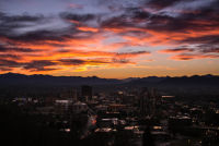
Sorta glad I stayed in NH. I got all work done and saw a stunning sunset on back-end of departing line of storms.
Sounds like a helluva event in SW CT.
-
Danbury is about get hit really hard.
-
Look like our mini-supercells merged into a line now.
-
6 minutes ago, Yester said:
Does that mean from that point on, less likely to cause a tornado? Sorry, anxious noob
Less likely.
-
Ehhh... these storms are moving into the area too early for me to get out of work and meet it in time.
-
5 minutes ago, Typhoon Tip said:
Wow,... 87/65 here
CAPE must be high -
1000 J/kg across most of SNE with 2000 J/kg over western CT. There's a 3000 J/kg lolli near NYC.
-
Tornado watch into central Mass and NE Conn.
-
Wow @ wind probabilities.
Thanks for suggestions, y'all! I'm not sure I'll make it to Worcester area in time, but we'll see!
-
7 minutes ago, ma blizzard said:
BWW in Shrewsbury off of rt.9 has good views to the west
pm me if you have any questions man
Looking on Google Streetview, that's a great view! The only question is whether or not I can make it in time as it's a hour and half drive from here. I might end up further east even though line should be stronger further west just because I can't leave until 4:30-5 pm.
-
Could use recommendations for a good viewing spot anywhere east of downtown Worcester for photography... if that's possible lol.
-
1 minute ago, powderfreak said:
Is the storm threat that thing moving into ALB area now or is it going to be south of there later, associated with like the outflow boundary of that current line of storms?
I'm heading to my folks house just SW of ALB and it's pitch black off to the west with good lightning visible from I-87.
The latter. What you're seeing is the first round that'll move through S VT, S NH, and north of I-90 in Mass. It'll lay down that OFB south of these storms for later event like you mentioned.
-
Clouds cleared out of western Mass and CT. They should be good to go later this afternoon.
-
1
-

Fall Banter, Observation and General Discussion 2018
in New England
Posted
I'm asking myself the same question