
WxBlue
-
Posts
2,718 -
Joined
-
Last visited
Content Type
Profiles
Blogs
Forums
American Weather
Media Demo
Store
Gallery
Posts posted by WxBlue
-
-
2 minutes ago, Chrisrotary12 said:
Admittedly, I'm going to be disappointed if I ping during this. Might not get the 18" GYX is calling for, but pinging would be a bigger let down. Still expecting arctic high to do its thing.
Even staying all-snow here, I'm having a tough time seeing us matching 16-18" forecast from GYX. I'm comfortable with my 12-18" call for my town.
-
1 minute ago, ORH_wxman said:
1037 is not weak.
And it goes up to 1039-1040 mb over upper Quebec during the event.
-
2 minutes ago, ORH_wxman said:
People are still suckers for the models despite one of their biggest weaknesses being handling strong CAD with an arctic airmass in place. Doesn't seem to matter how many times the discussion happens, there's always posts that defer to the authority of the model output.
I understand newbies wouldn't know about this right off the bat, but veteran posters should've learn by now about that weakness. There were several CAD-linked events in which surface temperatures were off by as much as 10-15 degrees. Likely the case again here.
-
10 minutes ago, Greg said:
A classic arctic high penetrates all layers not just the top and BL but mid levels also so they are not easily scoured out.
1037 mb high pressure screams "I'M A CLASSIC ARCTIC HIGH" to me. It's laying down the cold air at all levels ahead of the storm.
-
1 minute ago, dryslot said:
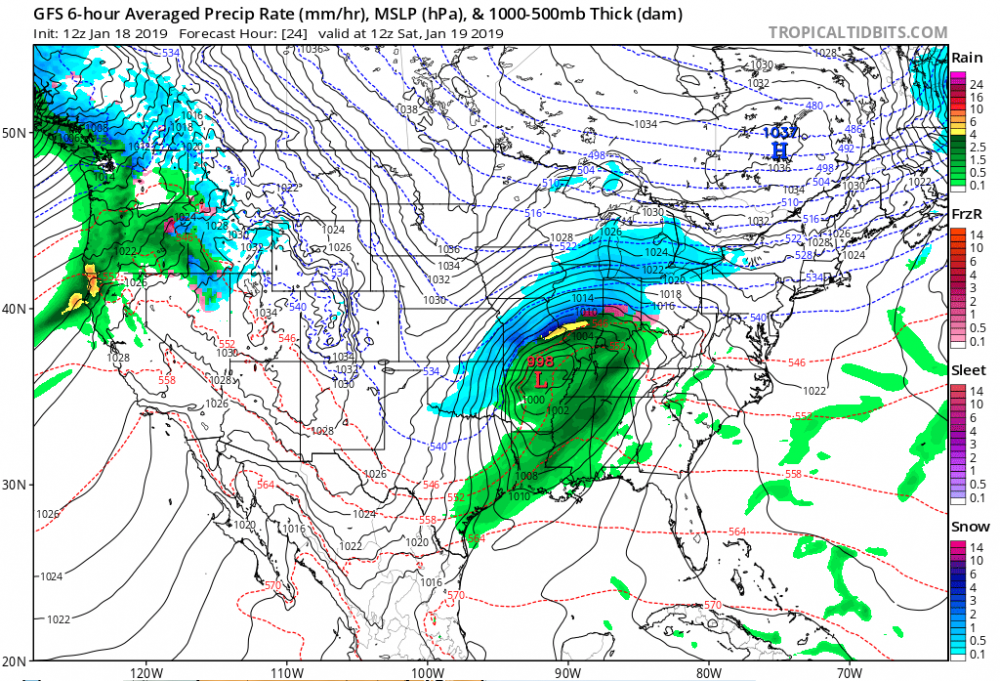
12z GFS is just a hair slower then 06z, Maybe a tic or two further NW.
Yep. Probably just a short-term noise here.
-
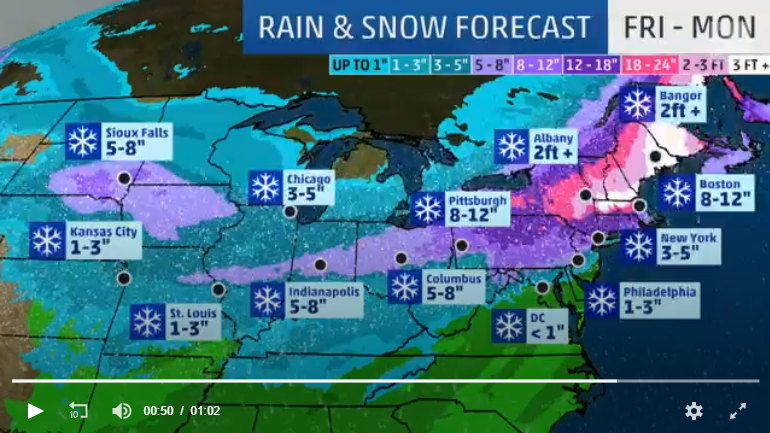
2 minutes ago, Greg said:
What the hell is the WC thinking? Fitchburge and Jaffery are not getting 30" - 35" of snow. Pretty damed sure of that even with a little elevation. No way.
They're thinking about ad money they'll receive from increasing views due to hype of #FAKENEWS.
-
It's a screenshot of a video so the quality is trashy, but the hype from Weather Channel is insane. Where are they finding 3+ feet of snow?? Please don't tell me they're using Kuchera ratio...
-
1 minute ago, wxeyeNH said:
10-15" sounds reasonable to me for Central NH. Few lollies to 18" perhaps. Nothing we can't handle. The hype around here is epic. This event will have a much lower impact than my 13" birch destroyer earlier this year.
If this was a bombing 960 something low moving up, stalling and pivoting in the GOM then I could see these 18-28" amounts. Even though this will have lots of moisture it moves along. Maybe I'm missing something as most of you delve into data much deeper than I do.
I actually agree with you. I don't think this storm has the longevity with the heavy precip for us to get over 18" in central NH.
-
Just now, dryslot said:
Yeah, I'm thinking of leaving it until monday morning here, I'm suppose to go to a party but doesn't look like that's going to happen, I'm not missing the game, And i have no one coming over, So i may just leave it alone.
I'm planning on hibernating at my place with lot of junk food for these championship games. I'm a Rams fan so you can imagine my excitement for this Sunday... I just hope this storm doesn't mess with the power (I don't think it will).
-
Just now, dryslot said:
Looked about 27hrs or so here, I don't know if i would call that quick.
Yeah, I deleted that comment after looking at the NAM again. I was thinking each frame as one hour interval... it's still early in the morning for me haha
-
 1
1
-
-
1 minute ago, WthrJunkyME said:
Lots of snow cream for you!

THANK YOU. This is such a great idea to make while watching my Rams in NFC Championship game

-
3 minutes ago, dryslot said:
I'm thinking about the same depending on final track, Low side if its more NW, High side if we get another tic or so SE.
3 minutes ago, dendrite said:I told my mom 8-14” for now.
Sounds reasonable. Maybe I'll compromise and go with 8-16" when chatting with co-workers tomorrow. That's a good starting point at least, depending on how far the sleet line make it northward on models.
-
4 minutes ago, HoarfrostHubb said:
I’ve been telling coworkers and friends to expect 8-12” in my area, but possibly a little more...details tbd
I don't know what to expect here. I like 10-18" for now.
-
6 minutes ago, dendrite said:
Mom just texted asking how much snow and said my sister told her that a woman at her work heard 24”. I wonder if that lady reads this forum and saw one of Ginxy’s snow maps.
Haha. Or that Weather Channel map. Few coworkers asked me about the 24" too.
-
 1
1
-
-
59 minutes ago, mreaves said:
Luckily, northeasterners are known for their slow, laconic drawl with little to no accent.
Funny thing is, for a southerner, I have no accent. But y'all do talk a lot faster up here haha.
-
 1
1
-
-
Considering attending to this, but my hearing is terrible (I'm deaf with cochlear implant) so I might get lost if conversation become fast-paced.
-
Y'all are making me feel better about turning 24. I was about 18 when I found out about AmericanWx as a lurker.
-
2
-
-
Got almost 2" of slush last night.
-
A part of me is glad I grew up experiencing these southern winters with 10"+ seasons being rare because, to me, anything that fall on the ground here still feel like gravy to me. So, as slow as this season has been, I still feel content as I'm used to it.
-
1
-
-
1 minute ago, CoastalWx said:
I meant your 43” lol. Last winter.
Yep! Had 19" from 03-08 event and 24" from 03-13 event. It was the deepest snow depth I ever experienced (26").
-
5 minutes ago, CoastalWx said:
Was that March?
It was indeed in March of 1993. Most of North Carolina's greatest storms occurred between late January and early March so it's bizarre to have a huge event like this in early December...
I doubt this event will reach 1993 levels (Boone saw 33 inches while Asheville saw 18 inches), but it's definitely up there with 1996 blizzard and January 2016 event.
-
2 hours ago, CoastalWx said:
At least the mtns of NC will get snow. I was starting to feel read bad for them. Anxiously awaiting Boone NC webcam images.
I still can't believe models are approaching to 20" in Asheville and Boone. That's Storm of the Century level of epic. If I didn't get 43" of snow in 5 days last winter, I'd be really salty right now.
-
1 minute ago, STILL N OF PIKE said:
Usually ends in tears for the piedmont
Yep, that's the biggest thing. It ALWAYS start with 15-25" medium-range model runs to get everyone hyped up only for the event to disappear because it's too warm or if the storm tracked too far north. Or if a warm nose sneaked in and turn 1-1.5" of liquid into ZR/sleetfest. The dread of disappointment is very real each event.
-
Taking a peek at our southeast subforum, I'm honestly glad I don't have to feel huge emotional swings run-to-run anymore. Comparing to New England, winter forecasting is MUCH more of a headache and a huge pain as models are lacking consistency all the way to last minute that we enjoy up north. You're dealing with several factors such as the track of storm, the type of storm, extreme terrain of western NC mountains, and the strength of cold-air damming. The result? Extreme snow gradients everywhere.
-
1
-

Winter Begins Jan 20th AWT
in New England
Posted
Still a bit ignorant of NE climatology, but I bet we'd be talking about the possibility of diamond dust as far south as Boston if that's the case.