

King James
-
Posts
853 -
Joined
-
Last visited
Content Type
Profiles
Blogs
Forums
American Weather
Media Demo
Store
Gallery
Posts posted by King James
-
-
Just now, RCNYILWX said:
We were on the fence there because of concern that transition would be relatively quick followed by a long lull with rain before changing back over. It was a tough call. Put it in the watch and hindsight could've put Kankakee in the warning but wasn't confident enough.
Sent from my SM-G998U using Tapatalk
Totally get it and appreciate the time you spend here. To me this is a happy surprise
-
 3
3
-
-
3 minutes ago, Stebo said:
That's quite a surprise considering that area was supposed to be right on the edge of things.
Yeah, definitely got lucky. I was up around 4 to catch the first flake and it has been ripping since. Rain / snow line stayed down near Watseka
Really good snow for snowballs. Lots of wind too
-
Not a Met but feels like warning criteria down in IKK. Don’t think wife will be able to get out of the driveway. Snow piling up over the wheel wells
-
IKK crushed this morning round. At least 4 inches out there I’d say
-
2
-
-
1 minute ago, Baum said:
looking out my window currently.
Told my wife my weather forum turned into a group of guys calling for rain while it snows out their window
SMH
-
 3
3
-
-
4 minutes ago, Chicago WX said:
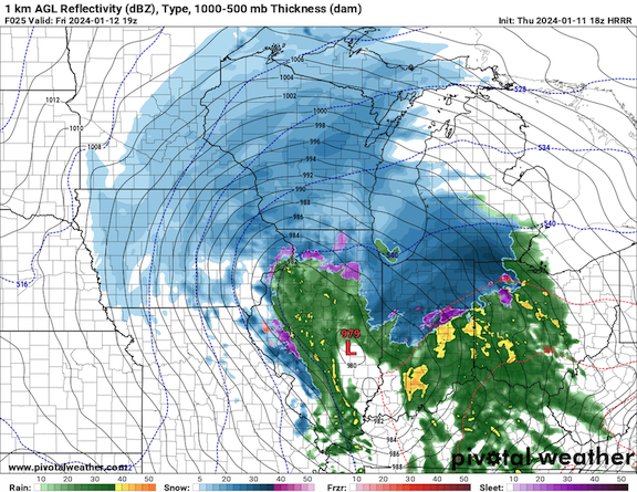
3.5" at my 6:00 measurement. Still ripping with good flake size. Only about an hour to go. Temp up to 32º. Latest HRRR and RAP says we're pretty much done after this band swings through, with temps getting into the 40's and then rain for the rest of the event. Hopefully we don't lose all the snow cover, but it's gonna be dicey. Alas, I'm pleased with this mornings snowfall...didn't expect it honestly.

Nah we are going to keep over performing. You and ALEK had us at nothing but rain and look at us now
We doing it
-
2
-
-
Just now, Imneversatisfied said:
NWS APX upgraded Alpena to a blizzard warning. This could be epic! Too bad I hurt my back yesterday fixing my truck so I won't be able to enjoy it as much as I could. Hopefully I'll b able to snowblow myself out. I got nowhere to go tho thankfully.
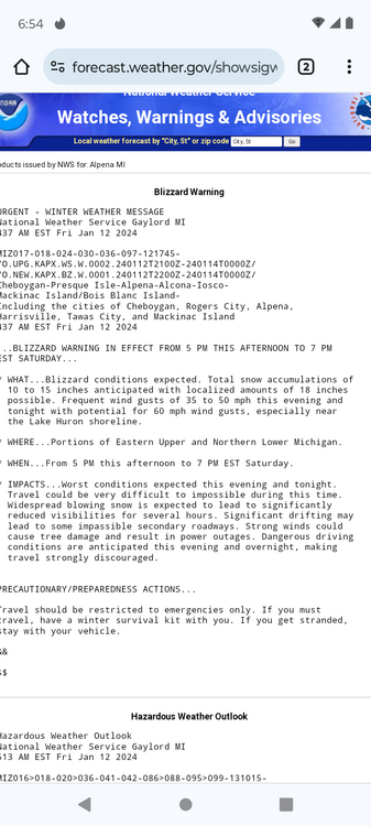
18 inches and 50mph winds. That’s big big dog club territory
-
2
-
-
Just now, TheRegionRat said:
My only resource for the changeover is the somewhat maligned HRRR. The latest run indicates several hours of snow before the rain moves in. Do other CAMs indicate differently? The scenario currently unfolding looks to be more than a nuisance.
Unsure my dude - I trust these guys on the forum and they say it’s going to rain, so that’s what I expect
But yes, already seems more impactful than what was forecast. Worried about my wife getting to work on these rural roads
-
5 minutes ago, TheRegionRat said:
Any chance the rain\snow line remains south of Route 30? Or the rain only lasts a couple of hours as opposed to four or more hours as modeled?
Hyperlocal, not a met, and no recent stays at the holiday inn….but the rain / snow line on the radar has been pushed back down around Watseka. Hasn’t made progress since the first flake here. Temp also fell from 31 to 29 since the start of the flakes
edit - town just lost power for 5 seconds or so
-
15 minutes ago, Chicago WX said:
Ripping. Went out and measured 2.0" on my board. Temp at 30º. Great start to this one.
")
Temp dropped a degree here the last hour. Hope we fight the rain for awhile
-
3 minutes ago, NEILwxbo said:
This seems dramatic but I don’t think I’ve seen rates like this since 2011. If there was a time since it was short lived for sure. Gonna exceed 5” by 5:30 at this rate.
Town is about a quarter mile from me and on occasion this morning the lights from town have been whited out. Has only happened a handful of times since I’ve moved here.
fun morning
-
Sorry dude
-
Wild out there right now. Dumping and wind whipped
-
3
-
-
Snow just starting here in IKK. Hoping for more snow than rain
-
2 minutes ago, Chambana said:
Only real ones would come to Champaign and ride out this 1/2” of powder whipped at 50mph. Wild times. Y’all will be missing out.
GFS about to break my heart. Recent history suggest I’ll be in the rain with you
-
3 minutes ago, sbnwx85 said:
#TeamGFS
This forum would be a lot of fun if we had a bookie
-
2
-
2
-
-
Chicago crew - Skilling has a ton of content regarding this storm on his FB page
-
1
-
-
31 minutes ago, Chicago WX said:

Couple interesting runs for our area this afternoon.
-
3 minutes ago, Chicago WX said:
12z GFS snowiest run yet for MBY. But most definitely, tossing the snow output as far as I can. We will be lucky to see a consolation inch at the very end. Looks good though for I-80 on north.
GFS has been super consistent. I’m sure we’ll get rain but it’s nice the GFS keeps me interested hyper locally
-
7 minutes ago, sbnwx85 said:
Oh what could have been. Final call: 5”
GFS a toss?
-
Very scientific
-
 1
1
-
-
2 minutes ago, Baum said:
it's called fear.
LOL
Goes from “Crush job N IL”
to
”Shame about this one “
-
Comments in this thread don’t make sense. 75% saying it’s great. 25% saying it’s terrible.
zero snow fall maps posted
-
1
-
-
1 minute ago, Chicago WX said:
Troll game still on point. Nice to see.
Euro did pretty good with the last storm, 3-4 days out compared to the other guidance. Only problem it has, along with other models, is it’s too generous around the southern/eastern edges of the wintry part of the storm, especially in very marginal air masses. I think I-80 and north in LOT’s CWA stands a good chance at 6-10”. And then obviously up through WI and then MI. IA good for a decent hit of WAA snows. For MBY, it’s a 99% rainer with a few token flakes at the end. Thankfully, this is the final big rainstorm for awhile. I’ll show myself back out the door now…
We are the kings of cold steady rain. Never should have moved south of 80
-
1
-
Jan 11-13th Blizzard
in Lakes/Ohio Valley
Posted
Winds seem to be whipping out of the E. Any chance that’s helping keep things snow south of 80?