CT Rain
-
Posts
26,269 -
Joined
-
Last visited
About CT Rain

- Birthday September 17
-

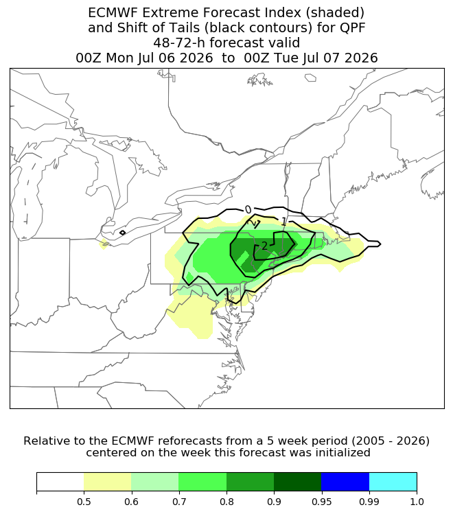
Hoisting the Sultan Signal: Heavy Rain Event July 5-7
CT Rain replied to WxWatcher007's topic in New England
I got like 1.25" yesterday. -
Lol you really dug to find that one.
-
His lawn will just wash away now after being Steined for a month.
-
Yeah 36 hours of that 850 fgen.... with 2" pwats on the south coast.
-
This is a big/strong signal for big rains.
-
Yeah was thinking that as well. The GFS is close to 60 knots at the top of the mixed layer at the coast.
-
Front might be a bit too fast.
-
It is? Here's the GFS.

-
89F so far at BDL. They should be able to tickle 90.
-
Nice timing too. Right around 18z plus more westerly flow in the BL vs onshore.
-
Wednesday's severe threat looks decent to me. Lapse rates are pretty good (6.5c/km) on the NAM and deep layer effective shear around 40 knots. Should be able to get a decent QLCS with some embedded supercells. I think the GFS is mixing out the boundary layer a bit too much.
-
Indeed
-
So did the GFS.
-
Lock it in. We can adjust higher if needed. Soundings on the 3km NAM would suggest 40 knots or so for HVN. Those gust maps are completely trash.
-
I did