jgf Posted May 25, 2016 Share Posted May 25, 2016 I have read a few articles about identifying shortwaves, but always have trouble doing so. Below, I have copied a portion of today's (07:47 EDT 5/25) AFD from the Upton NY office, on Long Island: First, for today, they say "deep layered ridging builds in" - i am pretty sure i see this in the upper level GFS charts - it arrives from the SW then, they say for thursday "deep layered ridging remains in control..., However a 700-500hpa shortwave passes over top of the ridge and through the area thursday afternoon" Can somebody find upper level forecasts that illustrate the shortwave passing over the ridge? i should note that in the foreast they say they slightly prefer the euro and the nam over the GFS, but I think it's just in the details - i think they are saying that the shortwave is present in all models. in any case, i was looking at pivotal weather, as they have upper level forecasts from each model i don't see the shortwave on thursday thanks 000FXUS61 KOKX 251147AFDOKXArea Forecast DiscussionNational Weather Service New York NY747 AM EDT WED MAY 25 2016.SYNOPSIS...High pressure builds to the south, then southeast, throughtonight followed by a weak cold front crossing the area onThursday. This front then lifts north as a warm front Thursdaynight, with high pressure building in behind the front throughSaturday night. A series of frontal boundaries then impact thearea from Sunday into Tuesday.&&.NEAR TERM /UNTIL 6 PM THIS EVENING/...Continued an SPS for patchy fog, locally dense at times, forthe Twin Forks of Long Island and portions of southern CT through9 am. Looking at local web cams, it does seem to be improvingsomewhat, however, given some of the recent observations, locallydense fog is still occurring.Otherwise, deep layered ridging builds intoday, with associated subsidence keeping cloud cover relativelyat bay, once any morning fog burns off, other than some passingcirrus in the afternoon. It appears the subsidence should also bestrong enough to keep any convection at bay this afternoon overthe County Warning Area (CWA), so have gone with a dry forecast.For highs today, a blend of mixing down from 825-775 hPa, perBUFKIT soundings, NAM 2-meter temperatures, and a mixture ofMAV/ECS/MET guidance was used. Highs should be around 15 degreesabove normal. It would not be surprising if a location of two inNE NJ, the Lower Hudson Valley and maybe even normally warmerlocations in NYC reached the 90 degree mark. The afternoonseabreeze should prevent any record highs from being reached.&&.SHORT TERM /6 PM THIS EVENING THROUGH 6 PM THURSDAY/...Deep layered ridging remains in control tonight and Thursday. Itwill be dry tonight, with only some high clouds around. However,a 700-500 hPa shortwaves passes over the top of the ridge, andthrough the area Thursday afternoon. This, coupled with surfacebased CAPE of 5000-1000 J/kg, Showalter Indices from -2 to 2, and20-25kt of Bulk shear over roughly the NW 2/5 of the CWA, warrantsslight chance to chance pops in that region.It should be noted that the ECMWF suggests that there should besufficient subsidence under the ridge to keep things drythroughout the area on Thursday. The GFS however suggests fairlyextensive convection over roughly the NW 2/5 of the CWA, with theNAM somewhat in between (though closer to the ECMWF than theGFS). Noting, that in addition to the passing shortwave, will alsohave a cold front sinking south into the region. Based on this, itappears there is enough forcing to warrant pops at this time.However, there is still the potential for no precipitation at allon Thursday. Link to comment Share on other sites More sharing options...
griteater Posted May 25, 2016 Share Posted May 25, 2016 You can see the weak shortwave with its trough axis centered over Erie, PA in the 2 images on the left (GFS model). Upper left is at 500mb; lower left is at 700mb. Four panel on PSU eWall is excellent for viewing: http://mp1.met.psu.edu/~fxg1/AVN_12z/avnloopnew.html http://mp1.met.psu.edu/~fxg1/ewall.html Link to comment Share on other sites More sharing options...
jgf Posted May 26, 2016 Author Share Posted May 26, 2016 it always amazes me that meteorologists find these tiny raster plots useful... but i think i see it - did i get it right? if you had to pick one level that is the best to check for them, what would it be? i have read 850... Link to comment Share on other sites More sharing options...
griteater Posted May 26, 2016 Share Posted May 26, 2016 it always amazes me that meteorologists find these tiny raster plots useful... but i think i see it - did i get it right? if you had to pick one level that is the best to check for them, what would it be? i have read 850... Yes, your red line is the shortwave trough axis. Shortwaves are most commonly referenced to the 500mb level. The eWall maps are good for seeing loops of multiple levels of the atmosphere, all on one page (via the 4 panel)...but yes, they don't give you the 'blown-up' & detailed map of a single height level. More info on this topic: http://apollo.lsc.vsc.edu/classes/met130/notes/chapter12/long_short_waves.html http://www.wxonline.info/topics/waves.html http://www.atmo.arizona.edu/students/courselinks/fall12/atmo336/lectures/sec1/p500mb.html Link to comment Share on other sites More sharing options...
jgf Posted May 27, 2016 Author Share Posted May 27, 2016 so in today's AFD there is more discussion of shortwaves.... this time, there is something that i have seen before in text forecasts.., and wondered about. in particular, they are discussing shortwaves that seem to be of a significantly shorter wavelength than the one we identified above - they talk about several of them moving through in a single day... for today: "Shortwaves moving through today are progged to be weaker than they were 24hrs ago.." and for saturday; "...no significant lift outside of weak mid-level shortwaves..." so they are forecasting multiple shortwaves moving over the area in the next 24hrs - what is that based on? If i wanted to be able to make that forecast.., where would i look for the evidence? I have looked at the 700mb forecasts, but don't see multiple shortwaves 000FXUS61 KOKX 271827AFDOKXArea Forecast DiscussionNational Weather Service New York NY227 PM EDT FRI MAY 27 2016.SYNOPSIS...Bermuda High pressure will remain across the region through theweekend. A cold front will pass through the area Monday intoTuesday. High pressure returns for the middle of the week.&&.NEAR TERM /UNTIL 6 PM THIS EVENING/...Convection has fired well nw. Will need to keep an eye on westernzones, west of the Hudson, for possible shower and thunderstormdevelopment early. HRRR continues to develop convection, alongthe seabreeze boundary. Will seabreeze boundary be enough tobreak the cap. With increasing cape as the afternoon progresses,coverage increases warranting chance pops.The forecast remains on track.Shortwaves moving through today are progged to be weaker than theywere 24 hours ago. No changes to temps at this time. 850 mb tempsand sea breeze progress should be close to those of yesterday, butyesterday featured a mostly sunny sky for most of the day for mostlocations. Will forecast high temps lower than what occurredyesterday. Looks like clouds will be more numerous and more opaquethis time around. Have gone above a guidance blend for hightemps, especially across Long Island where guidance has been toolow during the past couple of days.There is a moderate risk of rip current development at the Atlanticbeaches Today into this evening.&&.SHORT TERM /6 PM THIS EVENING THROUGH 6 PM SATURDAY/...An evening shower/thunderstorm is possible northwest of the city,then with the loss of instability and only weak lift, dryovernight.For Saturday, still no significant source of lift outside of weakmid level shortwaves, but SBCAPEs will be building once again awayfrom sea breezes. Again, will go with only slight chance tochance pops, focused more toward the afternoon and away from areascooled by sea breezes.Highs on Saturday should be warmer than on Friday with warmer tempsat the top of the mixed layer, and probably less cloud coveroverall. Again, needed to adjust a guidance blend upward to accountfor the low bias as of late, especially over Long Island. Link to comment Share on other sites More sharing options...
griteater Posted May 28, 2016 Share Posted May 28, 2016 so in today's AFD there is more discussion of shortwaves.... this time, there is something that i have seen before in text forecasts.., and wondered about. in particular, they are discussing shortwaves that seem to be of a significantly shorter wavelength than the one we identified above - they talk about several of them moving through in a single day... for today: "Shortwaves moving through today are progged to be weaker than they were 24hrs ago.." and for saturday; "...no significant lift outside of weak mid-level shortwaves..." so they are forecasting multiple shortwaves moving over the area in the next 24hrs - what is that based on? If i wanted to be able to make that forecast.., where would i look for the evidence? I have looked at the 700mb forecasts, but don't see multiple shortwaves In this case, there is ridging building in today at 500mb in your area. If you look at the 700mb Relative Humidity charts, you can see an area of increased moisture working over the top of the ridge from NY/PA into S New England today...but it's very, very subtle. A minor ripple as opposed to a "shortwave" Go here and take a look at the GFS/Mid-Atlantic sector/700mb/Relative Humidity: http://weather.cod.edu/forecast/ Link to comment Share on other sites More sharing options...
jgf Posted May 29, 2016 Author Share Posted May 29, 2016 I see the RH surge that you mention But, if we define a shortwave as a trough in the pressure levels between say 850 and 500mb.., i certainly don't see that there are several passing over my region... So.., is it the case that the forecaster who wrote the AFD saw the RH surge.., and just inferred that there must be several shortwaves (troughs in the pressure surfaces) passing over my region.., even though they are not resolved by the models? I am just trying to nail down the reason for that forecast Link to comment Share on other sites More sharing options...
griteater Posted May 30, 2016 Share Posted May 30, 2016 Those are good questions. It's possible the forecaster was using a higher resolution model (e.g. HRRR) which is more capable of resolving the smaller scale features. One thing of note is that weak shortwaves or ripples in the flow are more likely to influence the sensible weather during the warm season than during the cool season...that is, when abundant low level warmth and moisture are present, a weak shortwave can assist in providing the necessary forcing/lift for showers and storms....whereas during the cool season, such a feature may only lead to an increase in cloud cover. Link to comment Share on other sites More sharing options...
jgf Posted May 30, 2016 Author Share Posted May 30, 2016 I have looked at the HRRR i find it hard to use it for looking at pressure surfaces.., because it seems susceptible to contouring artifacts if you look at HRRR CONUS plots, they don't resolve small features if you look at regional plots, there seem to be spurious structures in individual contour lines that aren't reflected in adjacent lines I have also downloaded the HRRR grib files.., and then my own software does the contouring.., but i have the same issues. so, no, i haven't been able to identify small scale shortwaves in the HRRR The HRRR has been unavailable more than it's been available lately Link to comment Share on other sites More sharing options...
ohleary Posted May 30, 2016 Share Posted May 30, 2016 I have looked at the HRRR i find it hard to use it for looking at pressure surfaces.., because it seems susceptible to contouring artifacts if you look at HRRR CONUS plots, they don't resolve small features if you look at regional plots, there seem to be spurious structures in individual contour lines that aren't reflected in adjacent lines I have also downloaded the HRRR grib files.., and then my own software does the contouring.., but i have the same issues. so, no, i haven't been able to identify small scale shortwaves in the HRRR The HRRR has been unavailable more than it's been available lately The HRRR is available every hour of every day. Are you looking at the ESRL site? Because yeah, it's not always there. http://mag.ncep.noaa.gov/model-guidance-model-area.php Link to comment Share on other sites More sharing options...
jgf Posted May 31, 2016 Author Share Posted May 31, 2016 The HRRR is available every hour of every day. Are you looking at the ESRL site? Because yeah, it's not always there. http://mag.ncep.noaa.gov/model-guidance-model-area.php yes - i usually go to the ESRL site for HRRR graphics because i need more detail than is on the NCEP site but you are right - i see that even though it is not on the ESRL site, the model is still available i like to look at the OKX sub region on the ESRL site otherwise I download the gribs from NOMADS, and can view the model in it's full resolution - i see the gribs are available today, even though there is nothing on the ESRL site. I guess i don't really understand how such low res graphics as the ones on the NCEP HRRR site are that useful to you guys, but i guess they must be... my main interest is wind.., and its variation over short distances, so even the OKX graphic really isn't that great my main problem is that NOMADS is quite cumbersome to use - i have to select and download a separate file for each forecast time if i was more clever, i could probably write a script to download the HRRR grib for all the forecast times, and for the region and variables of interest to me Link to comment Share on other sites More sharing options...
jgf Posted August 10, 2016 Author Share Posted August 10, 2016 Quote 000 FXUS61 KOKX 101444 AFDOKX Area Forecast Discussion National Weather Service New York NY 1044 AM EDT WED AUG 10 2016 .SYNOPSIS... Bermuda high pressure will remain across the Western Atlantic through the weekend. A cold front approaches on Monday and moves across Monday night into Tuesday. && .NEAR TERM /UNTIL 6 PM THIS EVENING/... The area will remain under the influence of Bermuda high pressure through today with ridging over the northeast. A weak shortwave and associated convective complex were moving through the ridge and sagging into the forecast area. Additional convective vort maxima will move through the ridge today, increasing the chance of showers and thunderstorms. These storms will track along the periphery of the ridge with the higher chances of precipitation across the lower Hudson Valley into southern Connecticut. There will be little shear and steering flow, with increasing isentropic lift, along with diurnal instability. With a deep layered moisture influx from the Gulf of Mexico there is the potential for areas of heavy rainfall as the storms will also be slow moving. so that's the Upton AFD for this afternoon another shortwave forecast..., but I struggle to see it.., i see the high.., not sure i would really say new england is under a ridge though... i do see a long wavelength, small amplitude curve in the contour that passes just N of PA is that it? Link to comment Share on other sites More sharing options...
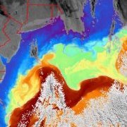
ohleary Posted August 10, 2016 Share Posted August 10, 2016 Probably need to look lower. 850mb, look over NY: 700mb: pretty evident here, see the RH just upstream of the shortwave in New England: Link to comment Share on other sites More sharing options...

Recommended Posts
Archived
This topic is now archived and is closed to further replies.