

brooklynwx99
-
Posts
5,640 -
Joined
-
Last visited
Content Type
Profiles
Blogs
Forums
American Weather
Media Demo
Store
Gallery
Posts posted by brooklynwx99
-
-
12 minutes ago, 40/70 Benchmark said:
CC probably did play a role in that, too....I am in agreement with the idea that it fosters greaters variability with the overall trend line pointed downward, but that doesn't mean that you have to go robocop on people to tie it to every missed opportunity for a snowstorm. There have always been misses and rough stretches during which the misses far outnumbered the hits.
there was a span of time where pretty much every KU pattern hit from like 2016 through 2021, and people got spoiled and thought that would continue... I am one of those people and have tried to remove that bias. it just happened so often that it was easy to assume that kind of loaded WB -NAO pattern would give a 75-90% hit rate - in reality it's much lower
-
 3
3
-
-
17 minutes ago, Typhoon Tip said:
It's been time for about 7 years ... just imho -
CC is absolutely a factor, that is not a debate. snowfall is just so prone to variance and we came off of such a torrid stretch that I want to give it another 10 year span to make sure that this isn't just regression to the mean. it'll probably be 75% bust, 25% boom seasons from here on out with very little in the way of true average
-
1
-
-
2 minutes ago, 40/70 Benchmark said:
Maybe it edged a bit east, but it never looked great.
agreed, that was always the main issue with that setup and made it a lot more precarious. if it had a true +PNA, easy KU. one could attribute that to CC, but we were never going to see perfect +PNAs with every setup. I think a lot of it is regression to the mean
i agree with you that if this is still happening in a decade, it's time to have a serious convo
-
 1
1
-
-
3 minutes ago, 40/70 Benchmark said:
I think the system lacking cohesiveness was do at least in part of the crap PNA ridge. I agree with you, though....CC definitely isn't making it any easier, but its not the only reason.
yeah, that did not help. what was interesting was I remember the PNA ridge trending "better" as the event moved up, but the ULL deteriorated to the point that it didn't matter. just kinda became messy because of weird ULL stuff. they're finicky, always have been
-
I think part of it is that back in the 2000s and 2010s, most KU setups delivered (March 2018 is a great example), and now we're seeing some flies in the ointment. sure, some of those failure modes are popping up more and more because of CC, but I think we got a bit spoiled, so now a block pops up and everyone expects a KU (I am personally guilty of this and am trying to remove this bias)
mid-Feb easily could have occurred, the ULL just became a bit sloppy and the system became more disorganized... it still delivered historic snow to VA beach, and there was also a once in a lifetime Gulf Coast storm
-
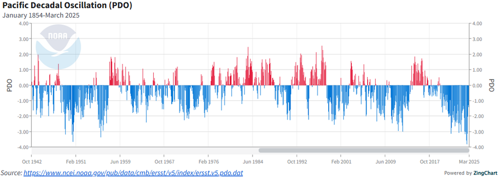
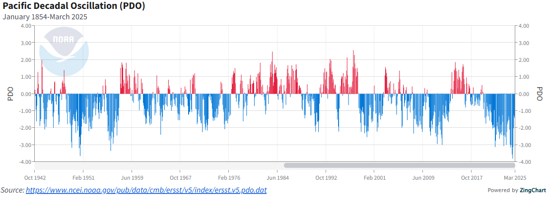
I don't think there's any legitimate way that the 2013-15 +PDO could be viewed as a "three year cycle" or whatever. there have been numerous instances of +PDO in -PDO cycles and vice versa since the 40s. it's nothing new. you can see the same thing in the late 50s, late 80s, and the mid-2000s. IMO it's just authors trying to rationalize typical variance as a broader consequence of climate change
-
2
-
1
-
-
35 minutes ago, Stormchaserchuck1 said:
It wasn't the same pattern as the last few Winters because the Southeast got several snowstorms. They were shut out the last few years. You act like because New York City had the same amount of snowfall as the last few Winter's that the pattern wasn't different, but it wasn't the same, at least through December and January. It was just drier. That drier pattern started last Summer when the cap wasn't breaking for anything, despite hot temperatures and high humidity in the Northeast. This "drought" pattern really only started in 2024.
the Southeast and southern MA is loving climate change right now
-
 3
3
-
1
-
-
Just now, Heisy said:
But the ridge, N/S and confluence out ahead isn’t changing so it’s still a no go
.the heights over British Columbia are higher again
-
simple, the GFS is tallest with the ridge out west and allows the NS to have better momentum
-
1
-
1
-
-
1 minute ago, weatherwiz said:
Not sure I would describe it as a phantom storm by the gfs. It's a product of phasing...the GFS is more favorable with both streams and promotes a better likelihood for phasing. It's not like a GFS solution doesn't make sense. If the GFS solution didn't make much sense then I would agree it is phantom but it wouldn't take much from the euro to output something closer to the GFS...and on the other hand it wouldn't take much from the GFS to lessen this idea.
the CMC and UKMET are also much better looking out west. I am definitely taking the GFS with a grain of salt but it's not that far off, and the PNA has been trending better for a while now
-
2
-
-
9 minutes ago, ORH_wxman said:
Yep. Not biting unless other guidance latches on…but particularly the euro. GGEM and Ukie can do what they want but if GFS/Euro start agreeing then it’s a legit threat.
FWIW the CMC did make some nice shifts synoptically
-
1
-
-
Just now, 40/70 Benchmark said:
GEFS def. seem more intense with the s stream for whatever that is worth.
the trend with the PNA over the last model cycle has been pretty nice. went from a trough to a full latitude ridge on the GEFS over BC
-
36 minutes ago, snowman19 said:
After 3/10, I think any consistent cold is done
agreed, though the trend for more -NAO probably does limit the extent of the warmth
-
1
-
-
1 minute ago, MJO812 said:
Correct
If only
Fail
I'm still depressed over this.
dude that was two weeks ago, damn
-
1
-
-
11 minutes ago, snowman19 said:
The EURO-AI already completely lost it
it's an operational model at 10 days out. it will do that, as will any other OP at this range
-
1
-
-
all ensembles maintain a signal for the 9-10th, just a matter of phasing. worth keeping an eye on
-
2
-
-
4 minutes ago, Heisy said:
GEFS showing the split flow and the short wave associated with the low we’re tracking
OP was a disaster but it was way too slow with the shortwave vs euro camp so probably wrong
Here is GEFs vs euro Ai, it’s smoothed out but you get the idea

.GEFS has quite a signal with lots of strong coastals
-
1
-
 1
1
-
 1
1
-
-
26 minutes ago, Heisy said:
18z GFS had the wave now.

.the transient 50/50 and -EPO do help this threat. the synoptics are there, it just needs to deliver with a phase
-
3
-
-
next shot at something more substantial is probably the 9-10th as the cutter drops the TPV down and a wave tries to amp into the colder airmass with the transient PNA spike. after that, it's likely curtains outside of NNE with some warm weather on the way
-
Just now, mitchnick said:
Heisey, et al., Pivotal has updated AI and now has snowfall. Here's the 6z run.

oh god please no
-
1
-
-
the AIFS humping is going to be unbearable for a while. past 5 days it isn't as good as any other model, really
-
3
-
1
-
-
Just now, 40/70 Benchmark said:
I remember I came in into this forum right after the 3' run for NYC and opined that it would be captured later and trend NE....it wasn't recieved well.

he shits on every storm threat that has ever formed
-
2
-
-
4 minutes ago, JetsPens87 said:
And this is happening one way or another...
Just not for us. Don't get what you're saying. They never had it for more than a few cycles. I don't really find this to be that stunning of a model collapse when it was over 5 days out.
i saw people even comparing this to Jan 2015. that was on a totally different level of fail. not even close
-
1
-
-
Just now, 40/70 Benchmark said:
120 hours.....capitulation was Saturday. Saturday AM everyone woke up naked in a hot tub with their laptops in hand....by Sunday AM they were all lying tits up.
yeah, trust me, it was one of the more stunning model collapses in the last several years. absolutely sucked


2025-2026 ENSO
in Weather Forecasting and Discussion
Posted
wouldn't be surprising if we had another -EPO dominant winter with intervals of blocking. still some -PNA, obviously. likely AN temps in the mean, but we'll probably have some colder intervals with blocking... overall, doesn't seem like too much of a deviation from last winter's vibe, which I would run back and see if the dice can roll a bit better