

aggiegeog
-
Posts
1,235 -
Joined
-
Last visited
Content Type
Profiles
Blogs
Forums
American Weather
Media Demo
Store
Gallery
Posts posted by aggiegeog
-
-
Now appearing likely that the freezing rain will sag south of a San Antonio to Texarkana line by Thursday morning. A massive area could see a coating of ice up to >0.25" closer to Red River.
-
On 2/20/2022 at 7:44 PM, vwgrrc said:
This one seems a bit interesting as it's harder than the event 3 weeks ago for models to reach any consensus at this range. What's even more interesting is that NWS suggested they're picking side with the colder ones like NAM/GFS than EU models. I feel most of time in the past they stayed mid-ground or even tilting warmer. Maybe they just have more faith in NAM in this set up. If that plays out, there could be some impact for the northern half of DFW.
Front is trending colder and faster vs models. Globals see mid levels and don't drive front south. This front has tons of momentum and it will drive south fast and likely won't slow until reaching the Gulf tomorrow night. Strong surface high pressing cold downhill regardless of upper level winds. This will be a long duration freezing drizzle event with temps in 22 to 26 range across N TX. For E TX, the freezing line will be much trickier but I'll side with colder models and go with 29 to 34 during the event for the Tyler area. That means ice on elevated surfaces but roads should be decent here. For N TX, roads will be bad Wed and Thu.
-
This week looks cold with a good chance for freezing rain in North Texas later in the week.
-
Snow beginning to accumulate in Lindale. I did not expect anything more than flurries so a nice surprise.
-
A nice dusting of snow across much of East Texas this morning from a decent little band of powder snow.
-
We are mainly sleet with some snow, very little ice buildup thankfully. We may get lucky and get a couple inches of sleet and snow instead of the forecasted 1/3" ice and 1/2" snow.
-
Freezing rain and some sleet here. Not much icing yet with 30F and no wind. Temp dropping so I expect more icing and more sleet shortly.
-
Freeze line hs arrived in my area. Raining moderately for a while now.
-
 1
1
-
-
Freeze line is basically from Junction to DFW to Paris. Here it is holding about 40 but heavier precip about to move in and temps look like it drops to mid 30s with that.Freeze line is basically from Junction to South of DFW (though Dallas itself is holding at 34) to Paris. Here it is holding about 40 with mid 30s just NW of here.
-
Not a high chance but if trends continue this could turn from expected ice storm to one of the biggest snows in DFW history.
-
19 minutes ago, TXHawk88 said:
For what it’s worth 0z & 6z HRRR have really bumped up the snow totals for DFW and brought freezing rain and sleet totals down a bit.
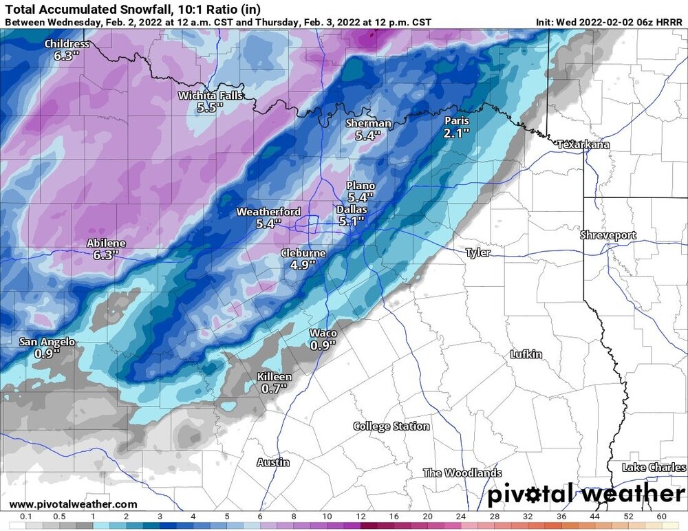
There are growing hints that this could be a snow event for DFW though I would still lean towards a primarily sleet event.
-
WRF is extremely fast with the cold and gets me down to low 20s by Thu morning. I think that is likely overdone but it does illustrate that the potential is there even far SE of DFW for a major winter storm. I think DFW is under 0.25" ice, 1 to 2" sleet and 1 to 4" snow with 6" possible for far northwestern DFW. I expect worst ice to be from Athens to Canton to Mt Pleasant where accretion may be pushing 0.5" for transition to sleet and snow. Ice line may make it down to a College Station to Marshall line. Below that only expect rain mixed with sleet late Thu and again Saturday.
-
1
-
-
Looks like 1-2 feet for the NM ski resorts. Upwards of 3 feet for the high peaks.
-
Beyond the big storm Thursday, the upper low Saturday has sneaky potential to lay down a white cover to the ice. GEFS starting to show snow on a few panels Saturday afternoon.
-
Agreed that without meso model support it is ok to delay a bit in watches, unless agreement comes before they may wait until tomorrow. The GFS has been amazingly consistent, though if meso models do not come into agreement by 12Z tomorrow the forecast is gonna be very difficult. If the high was over the Dakota's it would be much more of a slam dunk but it's a bit far east from ideal position so that especially East Texas has a couple mountain ranges in between. I still think areas west of a Waco to Tyler to Paris line are very likely to have significant icing. Longview to Texarkana are much more borderline.
-
28 minutes ago, vwgrrc said:
Thanks for sharing! Now at 12z, NAM starting to pick up this event. The frozen p amount seems lower than what GFS, CMC and ICON suggested at this point. I wonder how we read that? Is that a timing difference or mesoscale just has a better insight in this case?
NAM at this range is fantasy land. I'll start paying attention to the NAM and other meso models on Tuesday. I do not think we will gain much insight tomorrow with the storm offshore.
-
1
-
-
If the low drives into Mexico then all bets are off. We should get much better idea tomorrow and especially tomorrow night once the system enters the balloon network.
-
1
-
-
18 minutes ago, Ed, snow and hurricane fan said:
I wouldn't get too confident on anything until Euro and GFS converge. Globals not known for low level temp resolution, either, but it seems like mesoscale models aren't really good outside 48 hours, or Tuesday earliest to get *super* excited.
Euro has proven itself to be very unreliable and inconsistent with these type events over the past few years. ICON and GFS to a lesser degree are king in this situation. The combo of two very strong forces, 1050mb Arctic high and strong negative tilt short wave, make it very difficult for models to resolve. My opinion is to go on past experience which is the shortwave will be more SW than modeled and the surface cold will bleed south faster than modeled except in far eastern Texas where the Ouachita Mountains will block it.
-
2
-
-
There likely will be a 50 to 100 mile wide swath of major freezing rain impacts. My initial guess for it is centered around a Del Rio to Paris line. North of I-20 and west of I-35 could see heavy snow that begins as sleet closer to I-35. Heavy rain ending as freezing rain south of that line. Maybe an area of light snow later in day Thursday along and north of I-20.
-
4 minutes ago, Ed, snow and hurricane fan said:
I actually have no idea how to guess sleet over freezing rain, but cool 850s and subfreezing 925, I'm guessing sleet.
That's a pretty good rule, obviously not going to work every time but a good general rule.
-
1
-
-
ICON just like last year along with GFS seem to be leading the way on this event. Euro has major issues with these extreme events, Canadian is it's typical inconsistent self.
-
It is crazy how just flipping the page to Feb and all of a sudden moisture is no problem. Same as most every winter season. Snow before February has become very rare with last January being an exception, but that mainly missed the cities of Texas.
-
22 hours ago, DFWWeather said:
I completely agree! This is the best pattern and chance I've have seen this winter for significant cold air dump and, in particular, wintry precipitation. Some models spreads showing potential of upwards 30+ degrees below normal for the DFW area. This is an excellent pattern if you are a lover of winter weather. Unfortunately, if we get a Arctic dump of this magnitude, it will again put strain on agriculture, infrastructure and the power grid for much of the state, much like last February. What is interesting is nearly every major global model and much of their ensembles have been in remarkable agreement in the evolution of the pattern since Monday. Something to watch for sure!
Having said that though, I am a bit on the skeptical side on precip largely because we have been devoid of any significnat precip here for months now (what October last time we saw more than an inch?). Much of the state in entering into severe drought status.
Thankfully NE Texas had a good rain event recently, and I think that is where this event will focus also. The whole region will be very cold but heavy precip will likely be confined to eastern parts of the state. There will be more waves following the mid week system though and those will pull moisture further SW the following week. Several consecutive days below freezing for the northern parts of the state with sub zero possible near the Red River in areas that get snow. This will put great stress on agriculture and infrastructure.
-
Next week has lots of potential for Arctic cold and winter precip across the Southern Plains.
Texas/Oklahoma Discussion & Obs Thread 2022
in Central/Western States
Posted
With the cold so shallow not sure drying will be an issue. Could lead to introduction of more sleet for North Texas as cold will be a bit deeper than expected. Main change is a large shift SE in the freezing rain line.