

snowdude
-
Posts
755 -
Joined
-
Last visited
Content Type
Profiles
Blogs
Forums
American Weather
Media Demo
Store
Gallery
Posts posted by snowdude
-
-
4 minutes ago, yoda said:
00z UKIE is major thump to ice to light rain/drizzle
I thought that was the case from what I saw but I don’t have access to snow map.
-
CAD is usually under-represented at this point on models and southern storms TYPICALLY come in faster than modeled. But this year has done its own thing. lol
-
 1
1
-
 1
1
-
-
CMC is also slower, high pressure still good, but storm totals not as intense as 12z.
-
6 minutes ago, jewell2188 said:
Sooooo you are basically saying it’s all but over

Well, no., maybe...haha...it's just been frustrating for sure especially when you forecast one thing and something else happens. Models really can't handle this pattern. But we've seen last minute shifts before and that can still happen. Not giving up yet,
-
I really like the RGEM as a model and it is WAY south now.
 Still time for a change, but we'll see.
-
 1
1
-
-
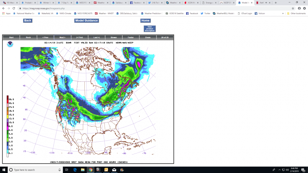
Not that I love the way they've been performing lately, but the latest 21z SREF increases snow totals big time.

-
 1
1
-
-
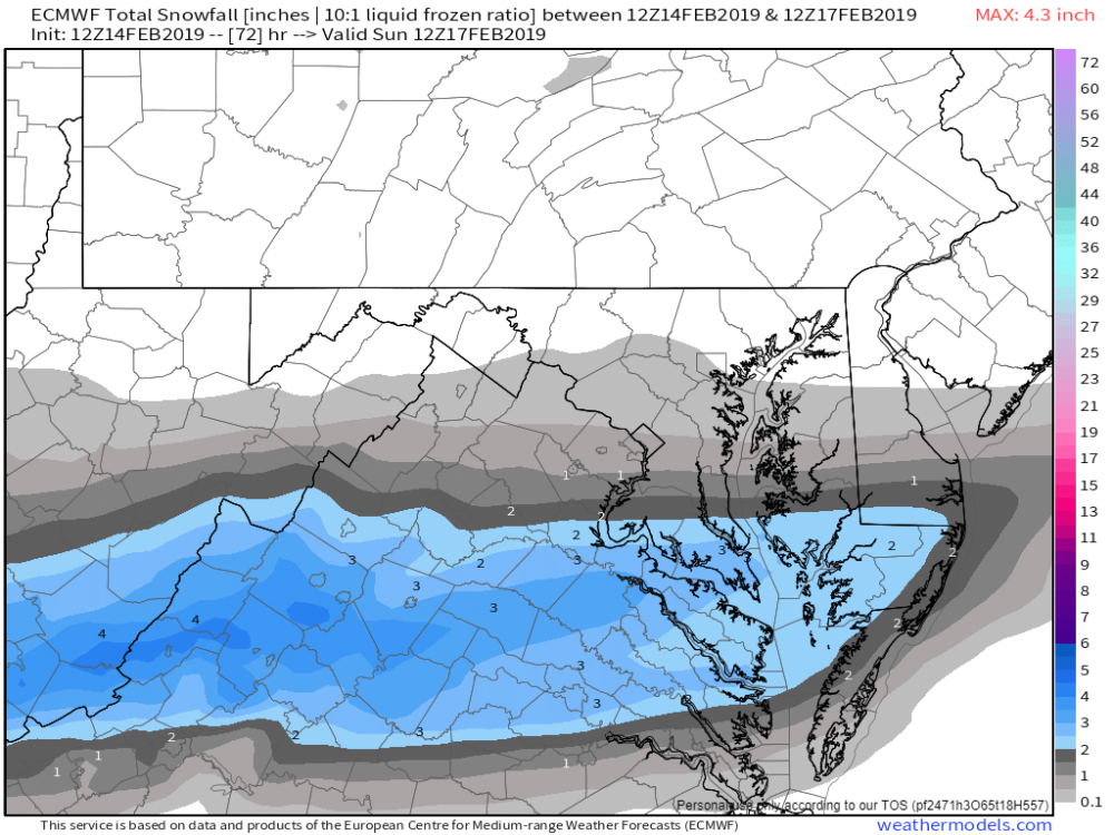
Today's 12z vs 18z euro that just came in.


-
1
-
1
-
-
Euro 12z vs 18z.

-
1
-
1
-
-
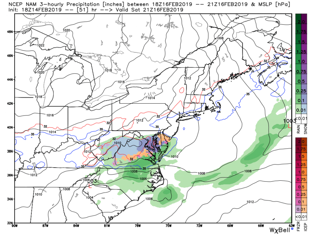
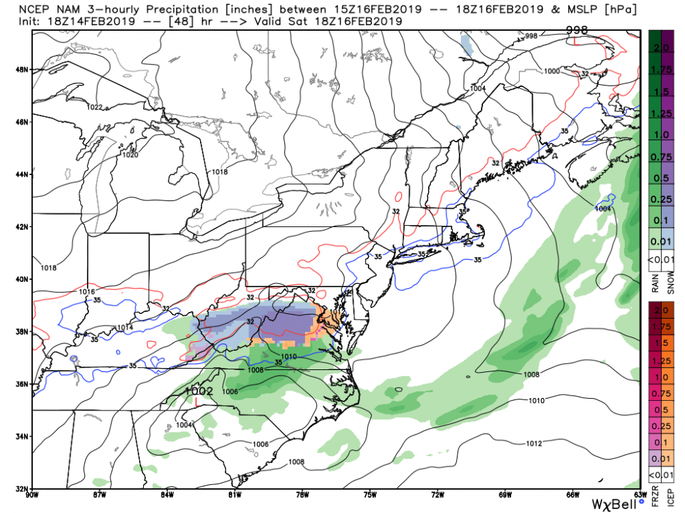
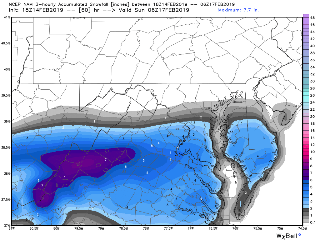
Oh NAM. haha. Playing catch up.

-
Next image
-
2
-
-
5 minutes ago, Deer Whisperer said:
nam?
Definitely more organized with precip shield much farther north.
-
4
-
-
Just now, wawarriors4 said:
Hasn't the UKMET been South at 48 hours out most of this winter? I mean in the 2/12-13 storm, it had EZF getting like 3-5" of snow at 48 hours and EZF got nothing close, same with a late January storm too, not saying that's the case here, just musing a bit I guess.......
Definitely! UKMET hasn’t been good IMO this winter.
-
1
-
-
UKMET and NAM a total miss while GFS a hit, CMC getting better, and EURO trended south last night but still some snow. This will be interesting as always. Major model busts coming for some.
Deep down I’ve always thought this one will work out for us. Hopefully I’m right! ❄️
-
2
-
-
UKMET way south, NAM way south. GFS and CMC basically a “hit” and the EURO has consistently been a hit until it trended south last night. Again, some models are going to bust big time.
-
Well this upcoming storm on Saturday seems to favor northern Delmarva, but there could be some accumulation into Salisbury. Let's keep tracking!
-
1
-
-
5 minutes ago, SnowGolfBro said:
Trending back to good?
Clearly worse for the DC area, but better for New England. No surprise there. At least it's pretty consistent with the snow over Lake Michigan, Lake Huron, and Lake Ontario.
")
But seriously, let's wait it out, these things are tricky.
-
1
-
-
1 hour ago, jaydreb said:
6z FV3 is as bad as 0z. All rain for DC metro.
The FV3 has just been horrid lately IMO and I’m afraid when it takes over as the permanent GFS.
-
5
-
-
Probably about 3-4 inches of snow in Cambridge this morning. Hoping for some nice banding later.
-
1
-
-
9 minutes ago, SnowtoRain said:
Good to hear. Basically same in Easton, might be closer to 1.5" to 2".
I haven’t been out in an hour or so. We may have over an inch. Looking outside it’s whitened up quite a bit.
-
Moderate snow in Cambridge. It’s a fight between big and small flakes. Everything covered. Probably 3/4”-1” on ground about right now.
-
1
-
-
19 minutes ago, CoastalWx said:
Include Kevin, he’d love to see it.
Me too.

-
2
-
-
2 minutes ago, Dereknel said:
Ric? Showing ice?
A little warmer this run with some rain pushing north.
-
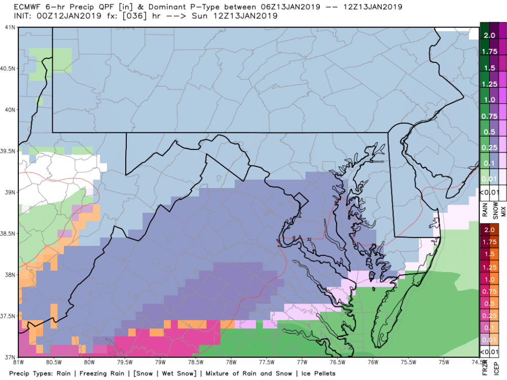
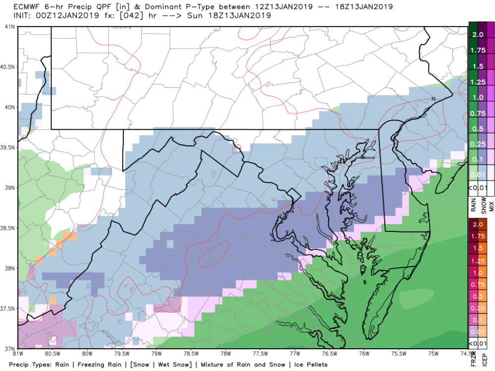
A bit of a slower and tucked storm. Has light snow in DC surrounding areas well into Sunday night. Snow not as good as 18z, about same as 12z?
-
1
-
1
-
-
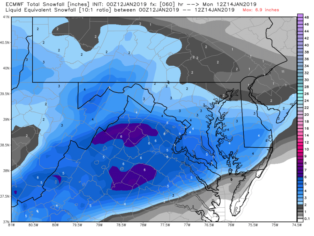
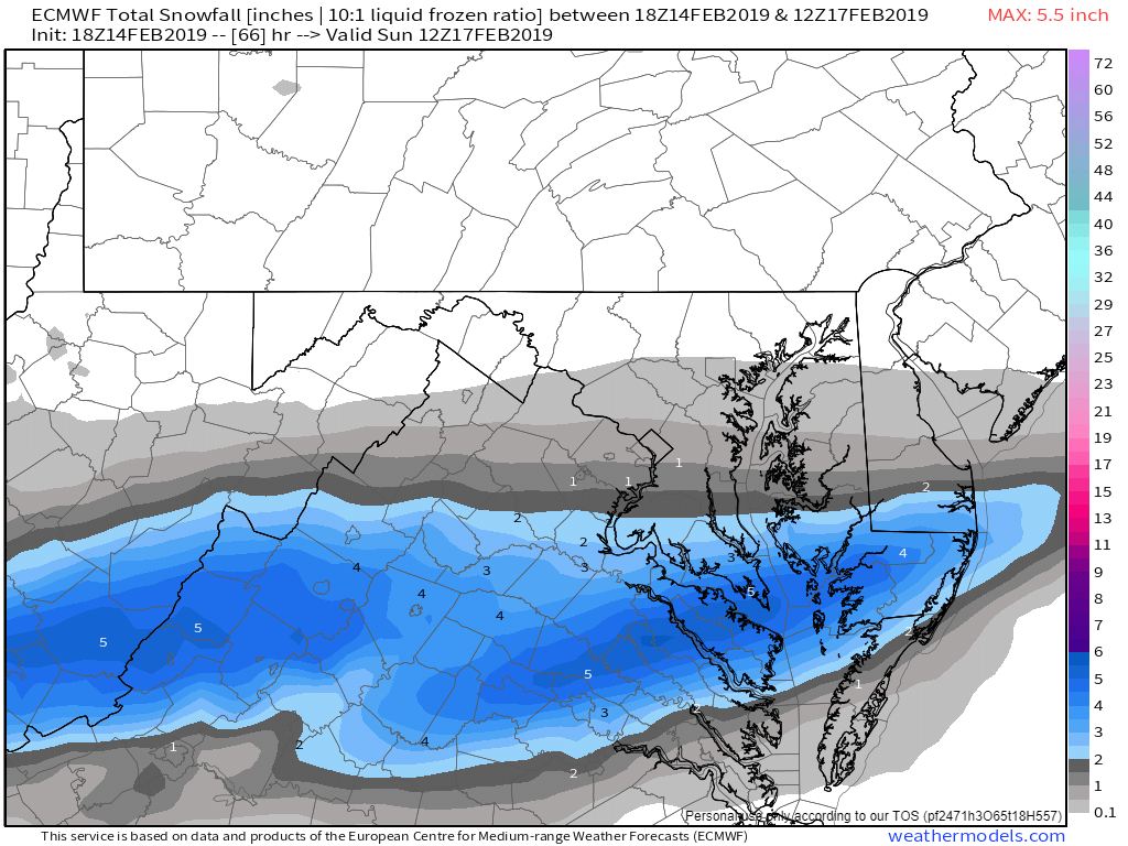
Mount Holly and Wakefield (as usual) not performing their best. Doubt it mixes in Easton, and Wakefield has gone from 4-6 inches in Salisbury, back to 3-4, and now back up to 4-6. They had less than an inch in Ocean City and now 2-3 inches there. Storm tonight on 00 guidance is slowling the storm down a bit, maybe ending later Sunday night/Monday morning. We will see! These storms LOVE to overperform.
-
3
-
1
-


The Mystical Month of February--Long Range Discussion
in Mid Atlantic
Posted
Big difference on Kuchera.