

brettjrob
-
Posts
2,592 -
Joined
Content Type
Profiles
Blogs
Forums
American Weather
Media Demo
Store
Gallery
Everything posted by brettjrob
-
Central/Western Medium-Long Range Discussion
brettjrob replied to andyhb's topic in Central/Western States
This is the biggest reason why I hate the second season. So many wasted setups over the past decade I can recall due to this problem. -
Central/Western Medium-Long Range Discussion
brettjrob replied to andyhb's topic in Central/Western States
Environment for Wednesday 8/20 in the mid-Missouri Valley should be very impressive for August. I haven't delved into the guidance enough to assess the likelihood and possible timing of CI, but the parameters certainly grabbed my attention. -
Historic Tornado Outbreak April 27, 2011
brettjrob replied to CUmet's topic in Weather Forecasting and Discussion
Interesting -- I'll check that out, and be on the lookout for any publications from his work. I've driven through the Hackleburg-Harvest damage path where it crossed US-72A near Trinity a few times already. Impressive. (Actually, when I visit my parents in HSV next, my trip will be bookended by that and the Moore/Shawnee paths on I-35/40 -- three incredibly impressive swaths across major highways). -
Reconsider majoring in meteorology!
brettjrob replied to stormguy80's topic in Weather Forecasting and Discussion
That doesn't make much sense to me, from a practical standpoint. A vet's "sacrifice," in general, does not correlate with forecasting aptitude or even the potential for development of such aptitude. (Granted, if the veteran was a forecaster in the military, that is valuable experience and should be treated as such). A graduate student or private forecaster, while arguably not "sacrificing" as much, has gained additional experience and knowledge relevant to the job. I'm not trying to minimize yours and other vets' sacrifice (any more than you were trying to minimize those of us in academia), but I do think that with such a surplus of applicants to most NWS positions, MIC's should be selecting from among the most-qualified. That will include some vets and some non-vets, of course. -
Devastating tornado strikes Joplin, Missouri
brettjrob replied to Hoosier's topic in Weather Forecasting and Discussion
It is somewhere in the neighborhood of 75%. -
Historic Tornado Outbreak April 27, 2011
brettjrob replied to CUmet's topic in Weather Forecasting and Discussion
Limestone/Madison Co. tornado (W HSV area) rated EF-4 with upgrade to EF-5 possible: http://forecast.weather.gov/product.php?site=HUN&issuedby=HUN&product=PNS&format=CI&version=2&glossary=0 Video of the wedge approaching I-65 near Athens/Tanner: -
Historic Tornado Outbreak April 27, 2011
brettjrob replied to CUmet's topic in Weather Forecasting and Discussion
I was focused heavily on the HSV-area storms yesterday, since I have family there, and I agree to an extent. It appeared to me that the outflow boundary from the MCS may have been draped across the northern row of counties in AL for several hours during the height of the outbreak. One storm in particular, which initially produced the catastrophic Hackleburg/Phil Campbell tornado, seemed to weaken a bit as it moved northeast from that area. Then, it suddenly went crazy upon reaching the Tennessee River, producing the Limestone Co. wedge near Tanner/Athens with visibly much-lower LCL's than the southern storms. For the rest of the afternoon, supercells trained over this general corridor and would each develop strong low-level rotation as they entered the Dectaur/Huntsville metro area. On the other hand, it still seems that the most prolific, violent tornado-producers were over the open warm sector, south of any clearly-defined boundaries from early convection. So, while I don't believe the MCS is what "made" this outbreak by any means, it may have at minimum not reduced its overall severity. -
Historic Tornado Outbreak April 27, 2011
brettjrob replied to CUmet's topic in Weather Forecasting and Discussion
RIDICULOUS debris ball over Hackleburg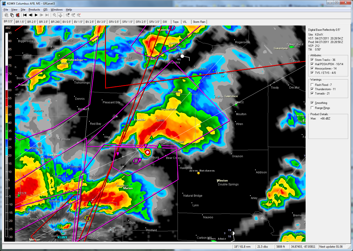
-
Historic Tornado Outbreak April 27, 2011
brettjrob replied to CUmet's topic in Weather Forecasting and Discussion
Cullman tower cam video will go down as one of the top tornado clips of all time, IMO. -
Reconsider majoring in meteorology!
brettjrob replied to stormguy80's topic in Weather Forecasting and Discussion
I can think of counterexamples from personal experience. I can think of counterexamples from personal experience. Not saying those aren't good rules of thumb, but you have to remember that like any other situation involving human discretion, the acceptance/hiring/promotion process in this field has its flaws. -
Reconsider majoring in meteorology!
brettjrob replied to stormguy80's topic in Weather Forecasting and Discussion
Here's something else anyone looking into meteorology should know, particularly if they're already considering the possibility of a graduate degree: Graduate students in this field are almost universally paid employees of the university they work for, and their tuition is waived by the department (for TA's) or their advisor's grant (for RA's). So not only will you pay little or no tuition in graduate school; you'll also be paid a stipend that's comparable to an entry-level job in forecasting. And if you're fortunate enough to get a fellowship, you might well make more as a graduate student than your peers make in the private sector for their first year or two. I guess my point is that graduate school for meteorology should not be seen as a financial burden. Unlike some other fields, where doing your M.S. is a short-term financial investment for long-term financial gain, this is usually a wash even during the years you're in school. (Of course, that speaks as much to the horrid job market for B.S. grads as to the relatively cushy situation grad students enjoy, lol). Just throwing that out there since I didn't realize it until I was at least midway through my undergrad degree. -
Reconsider majoring in meteorology!
brettjrob replied to stormguy80's topic in Weather Forecasting and Discussion
Exactly. And it's getting exponentially worse. The OP probably exaggerated some claims, and he clearly has a personal bias, but I think the same applies to a lot of the happy working meteorologists who are still encouraging people into the field. The truth is somewhere in between. Unfortunately, given the extreme negativity of the OP and the cautious wording from even the most gung-ho optimists, that middle ground is not too pretty. Here's something every prospective met student needs to understand: hard work and good grades do not guarantee you a whole lot these days. The only thing that's a guaranteed pass to success is knowing and being cozy with the right people. In many cases, that trumps everything else. Also, I think it's worth noting that this discussion seems very forecasting-centric. I went into school thinking forecasting was my calling, but now I'm working with numerical modeling as a grad student, and I've become more open to a career in research or model development. Even research and academia are very competitive in this field, since -- as others have noted -- the number of M.S. graduates is exploding now (vicious cycle: more kids can't get jobs after graduation, so they go to grad school as a last resort, deflating the value of an M.S.). But at least employment in research and modeling should continue to grow, whereas manual forecasting seems less certain, especially in the long-term. So if you're open to using numerical modeling or research as an outlet for your passion rather than just forecasting, the outlook is at least marginally better -- but it will, of course, require several more years in school.