

DTWXRISK
-
Posts
3,412 -
Joined
-
Last visited
Content Type
Profiles
Blogs
Forums
American Weather
Media Demo
Store
Gallery
Posts posted by DTWXRISK
-
-
2 minutes ago, NorthArlington101 said:
don’t want to argue with you about it because I respect you and know you are much more knowledgeable than me! I genuinely hope it holds steady with what it’s got.from DC ARLINGton perspective I see what you mean -- best stuff may stay south of you
-
 1
1
-
-
0Z EPS this is an INCREASE ins snow amounts on the eps when compared to the last few runs

-
1
-
-
-
18 minutes ago, NorthArlington101 said:
it didn’t not cave, didn’t look any better than 12z. 0z looks worse than 6z IMO. Might end up working for you and it could work for me if I was desperate enough to drive to Cville, but barring major changes (which there could’ve) I think it’s safe to say Euro/EPS is on an island and is slowly caving.7 hours ago, NorthArlington101 said:18z EURO caved, for those who still care.
18z EPS did NOT cave
DO NOT AGREE
-
-
JUST IN CASE YOU DID NOT NOTICE... since the time I left ... Oct /Nov 2016
we have NOT have BIG widespread northeast US snowstorms---
ya know like RDU/ GSO to BOS snowstorm big KU event
we have been close a few times DEC 8-10 2017 Jan 3-5 2018 March 6-8 2018 DEC 12-13 2019-
1
-
-
5 minutes ago, wxsniss said:
Let's revisit 7pm tomorrow to see if the changeover has not happened in Boston metro.
Haven't seen anyone here tonight say they are expecting the 10:1 snow maps.
Likewise, surely you're not claiming the SV maps you posted with 2-4" in ORH is likely.
No of course not SV is often way too conservative.... ORH 70% chance of 10"
50% of 15" 25% chance of 18"-
1
-
-
JUST IN CASE YOU DID NOT NOTICE... since the time I left ... Oct /Nov 2016
we have NOT have BIG widespread northeast US snowstorms---
ya know like RDU/ GSO to BOS snowstorm big KU event
we have been close a few times DEC 8-10 2017 Jan 3-5 2018 March 6-8 2018 DEC 12-13 2019
-
3
-
-
JUST IN CASE YOU DID NOT NOTICE... since the time I left ... Oct /Nov 2016
we have NOT have BIG widespread northeast US snowstorms---
ya know like RDU/ GSO to BOS snowstorm big KU event
we have been close a few times DEC 8-10 2017 Jan 3-5 2018 March 6-8 2018 DEC 12-13 2019

-
1
-
-
6 hours ago, NorthArlington101 said:
18z EURO caved, for those who still care.
18z EPS did NOT cave
-
6 hours ago, Buddy1987 said:
Even down this way?
who ever said that about 18z euro was wrong sw va will do ok with this little event
-
6 hours ago, BristowWx said:
The fact that we have said “the Euro caved” more than once is like being on some alternate universe. I am quite optimistic about this winter.
18z eps did NOT cave
-
13 minutes ago, NorthArlington101 said:
00z euro just tried to bring it back a little. Barely, but it’s there.

that said, this ain’t happening
dont over react yet
-
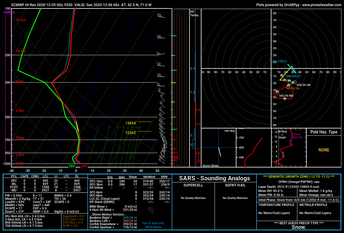
2 minutes ago, ORH_wxman said:
The 10 to 1 maps are def wrong for BOS.
I don’t think the lowest 1500-2000 feet of the 00z sounding looks realistic though for BOS at 00z. It has extremely heavy precip over them but a steep low level lapse rate despite N/NW wind. That should prob be like 32-33F paste.
My guess would be BOS gets several sloppy/pasty inches if the euro came to fruition (and adjusting for the lowest 2k feet)
VERY POSSIBLE.... the reason why i said if the EURO NAM soundings are correct
-
1 minute ago, jm1220 said:
If there's a wicked CCB band through much of SNE east of I-91 still, anyone Rt 128 and west is snowing like crazy and the winds at Logan turn N, that's all I need to know especially with the trend toward slowing down. Maybe I'm totally wrong, I'm an outsider but seen many of these type of storms. That gets even Logan to 6+ maybe even 8+.
yes west boston 100% DIFFERENT
-
2
-
-
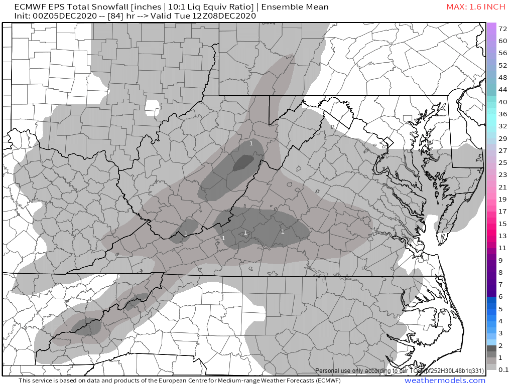
Just now, MJO812 said:
0z Euro snowmap

I DONT love the SV graphics that much BUT at least they are realistic and not full of 100% ruyan maue Joe bustardi dog shit snow weenie
jerk off as if I am looking at dirty pictures snow maps-
 2
2
-
-
12 minutes ago, wxsniss said:
Crushing into BOS metro on 0z Euro
Jerry will like this at his next pee stop
no one looks at the EURO or 0 NAM soundings
DANGER WILL WEENIE ROBINSON DANGER-
1
-
1
-
-
1 minute ago, jm1220 said:
Congrats to you Boston guys hopefully as you leap a light year ahead of NYC in snowfall. Such a cringer down this way and what could've been. We get the same banding and dynamics but a few degrees too warm so it's just rain or catpaws. Complete feast or famine these years here it seems.
JM BSOTON SNOW MAPS from all sources are going to BUST IF ...IF... IF.,.. these sounding are right
if Boston at 7- 8 pm sat is 37 dew point 36-
1
-
-
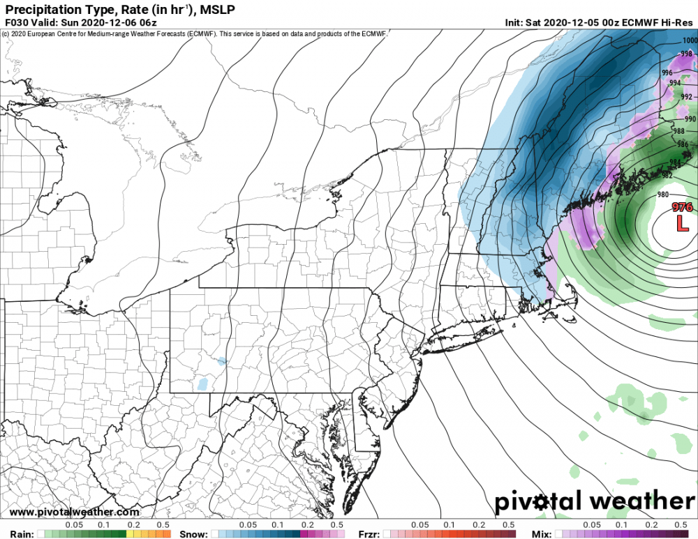
0z saturday euro sounding ar 7pm sat has BOST at 37 Td 34... thats NOT snow
at 30 hrs Temp is 34 Td is 28 and its about to END
-
On 12/5/2020 at 1:05 AM, dryslot said:

did u see the euro sounding? they in no way support BOS getting 10"
-
1
-
-
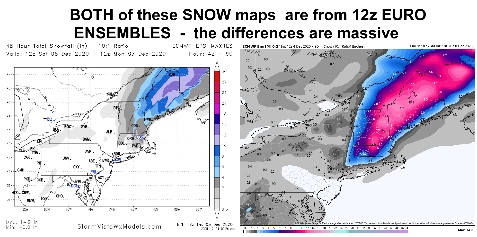
look at differencs between 12Z EURO EPS from 2 different sources

-
wow....
wxbell snow maps-- joke
-
1
-
-
3 minutes ago, powderfreak said:
Holy crap they still exist!
And they haven’t changed one bit, that’s fooking hilarious.

nothing for bos
-
1
-
-
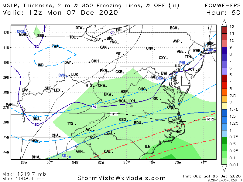
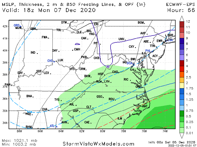
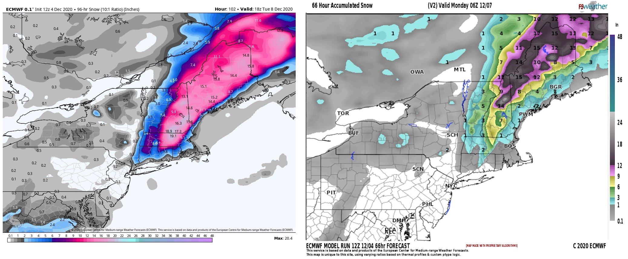
before it turns mild ... there is this ' threat"
.thumb.png.a6ec880eb14cf187988cded946e55398.png)
.png.e0bba2f9711a6de319715e220c0a1459.png)
.png.535506011d36dcf05cea5eec2d5803d6.png)
.png.44b6bf045cfb3cdeb27d6159af063b09.png)


.png.18ff57c602a223b6913684f62c156dd1.png)
GOOD CHANCE OF 1ST LIGHT SNOW EVENT VA / nw NC/ MD DEL MONDAY DEC 7
in Mid Atlantic
Posted
One of the reasons why we have ENSEMBLES Is to check the validity of the operational or deterministic models. In this case the operational 12z GFS is completely flat with only a little bit of precip in Southeast Virginia on the 12Z run. But as I'm sure you have all seen by now the 12ZGFS ensemble looks exactly like 0z and 6z European runs....
This should be a big clue for everybody that the operational GFS for whatever reason is still completely clueless when it comes to this system on Monday. The differences between the 12z GEFS and the operational GFS is simply staggering at 48 hours before the event.