

DTWXRISK
-
Posts
3,412 -
Joined
-
Last visited
Content Type
Profiles
Blogs
Forums
American Weather
Media Demo
Store
Gallery
Posts posted by DTWXRISK
-
-
-
LET ME GO UPDATE ( CRASH facebook)
-
 1
1
-
-
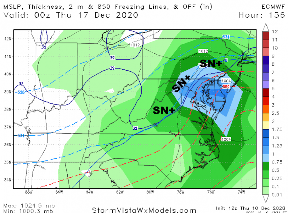
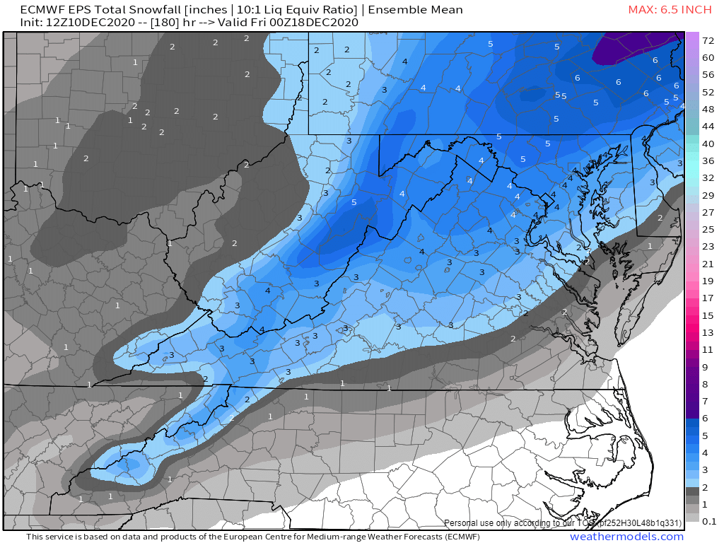
DCA NORTH VA BAL SNOW DROUGHT
-
 9
9
-
6
-
 1
1
-
-
8 minutes ago, leesburg 04 said:
Is this for Monday the 16th or Wed the 14th?
dec16
-
 1
1
-
3
-
-
.
-
11
-
5
-
1
-
 1
1
-
 1
1
-
4
-
-
Just now, Ji said:3 minutes ago, DTWXRISK said:at 40-45 degrees? Good luck with that
Cause gfs is dry. Icon is 32-34
yes at 90 hrs ...18z MON ..
BUT dude when the event begin at 12z Monday
DCA is 38 CHO is 40 Winchester is 35f
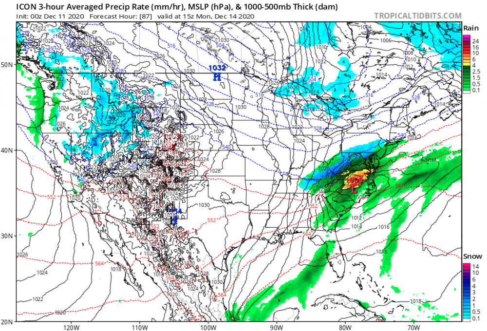
A lot of rain until 18z .... -
WARM SNOW???
what the hell is that?
is it like LIBERAL Bustardi???-
2
-
7
-
-
1 minute ago, Ji said:6 minutes ago, DTWXRISK said:the monday event is a cold rain
Icon is warm snow
at 40-45 degrees? Good luck with that
-
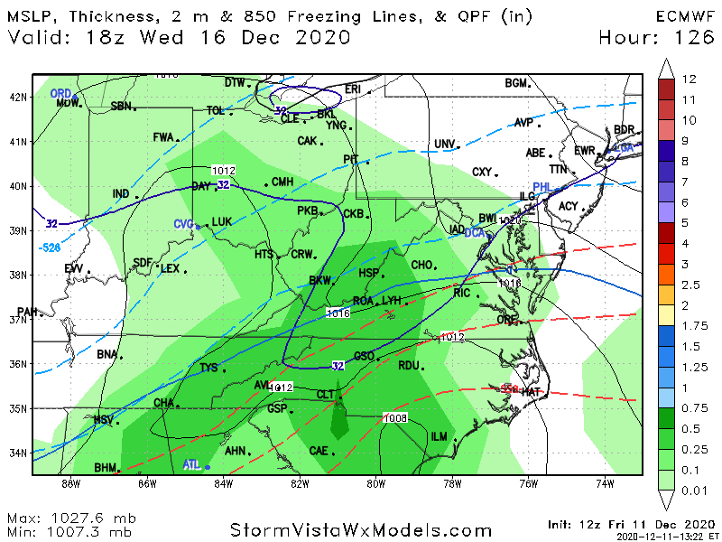
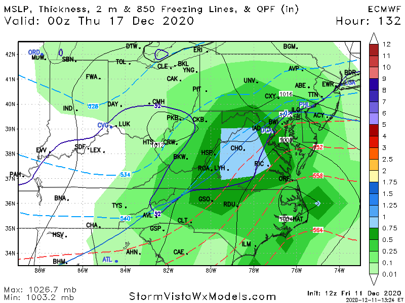
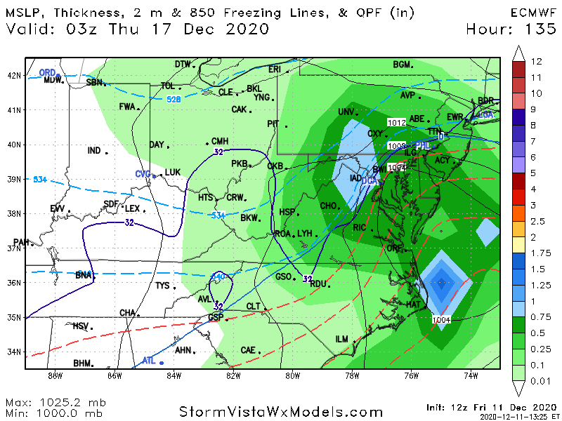
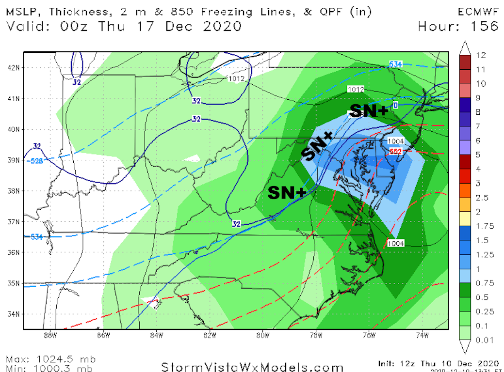
9 minutes ago, Ji said:11 minutes ago, jaydreb said:Here’s the pretty snow maps.

P13ftw
12 of 24 hit DCA BAL nw third of VA central MD with ACCUMULATING snow
-
3
-
-
47 minutes ago, Amped said:
Southern stream is weak. No low coming out of the gulf coast states.
its the GFS
that model simply does not see stj ast 72 84 hrs ... never has been
never will be
see the DEC 7 event here in central VA... GFS has NOTHING every run for 6 days until 42 hrs before the event -
58 minutes ago, stormtracker said:
I don't get the excitement for the Monday thing..maybe it's just me. The mid week thing is what I'm looking for. GFS has the High a little slower...which I think is a good thing. Looks more pronounced with CAD so far
the monday event is a cold rain
-
1
-
-
10 minutes ago, Ji said:15 minutes ago, psuhoffman said:The TPV pulls west and the next trough dives in too far west so even with a -AO/NAO that’s not so good unless it’s 2010 level blocking. But the guidance was doing that for this week not long ago and you were whining that the storms were tracking now were cutters. So...
Lol so much for the meterogically impossible to get cutters during a strong AO NAO block
no that not what it means
what it means is that
a) even if the model shows an inland track with - AO/ - NAO you should NOT accept that solution as validb) and it means after 15 years you have learned not a damn thing
-
2
-
8
-
-
1 minute ago, Buddy1987 said:
It is so freaking close here to it being a bigger deal. 2M in the mid 30s along the 81 corridor. I’m hoping rates can possibly turn it over to a wet a** snow. Looks great for the DC crew and that’s with it having a known warm bias.

counting on the ICON for snowstorm is a LOSE situation
-
1
-
-
1 hour ago, JakkelWx said:
Sheesh... does the ENS control even have any support from the mean? Hell of a way to run a strong NAO block with 50/50 confluence and a high over SE canada.
no one with a brain should ever look at the EPS or GEFS control runs
the only met I know that does that is a ****ing idiot Henry M-
1
-
2
-
-
1 hour ago, Ji said:
the models 48 hours before the storm will have 2 feet in Richmond and 4-8 in DC and 1 inch in philly to too right?
in a Miller B?
dude come on stop -
Just now, jaydreb said:
I think the confusion is that Wednesday is 12/16, not 12/14. People may think you were referring to Weds event and not Monday’s because you said Weds 12/14.
well i edited it a while ago but maybe you are right
-
1
-
-
18 minutes ago, Snowchaser said:
I did. Above 3,000 feet in West Virginia looks pretty good for wet snow.
snowchaser In my earlier reply I got the 2 event dates DEC 14 confused
you may be confused by what I ma saying here
My comments about rain in VA in western VA are for the dec 14 event ONLY
if you saw MY recent previous post I am BULLISH have been for more than 36 hrs about all of western VA for WED DEC16
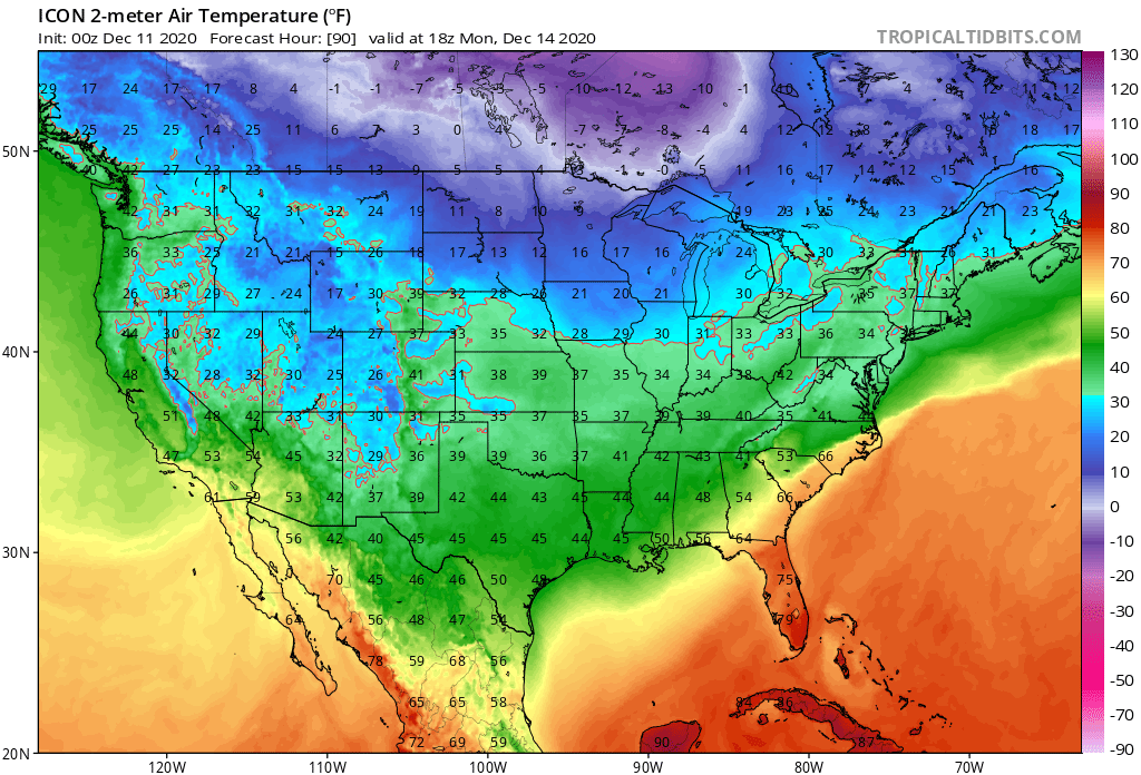
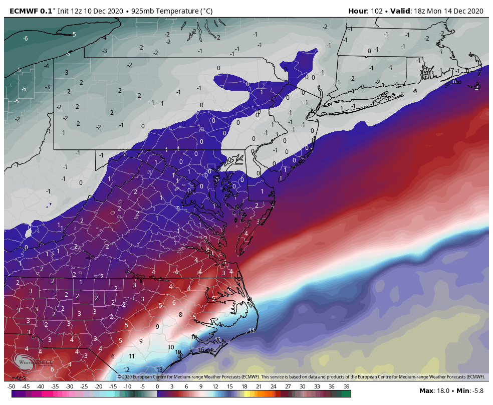
SURFACE TEMPS WED DEC 14 AM
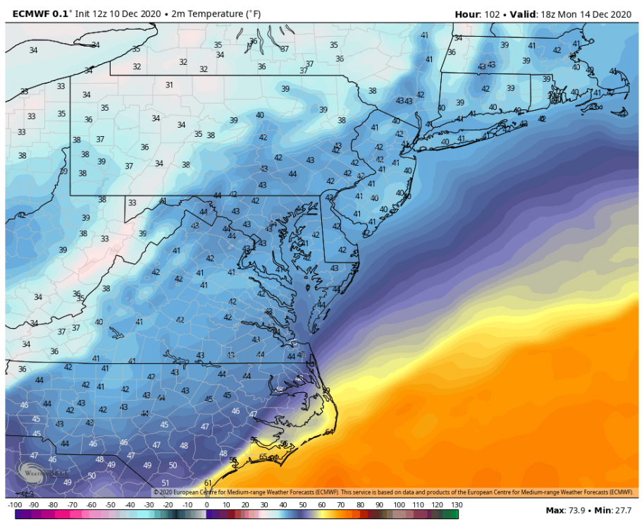
925MB temps well above zero.....

if YOU think you are going to get snow in westrn VA with temps 39-43 degrees and 925 mb temps above 0z ...
that not gonna happen
-
1
-
1
-
-
I DONT KNOW IF OTHERS POSTED THESE OR NOT
screaming ice storm VA Piedmont to snow...
BIG hit for sw va All of the Shend valley central / western MD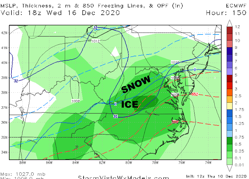
-
5
-
3
-
-
2 minutes ago, Snowchaser said:
Even in the mountains?! What are you smoking?

dec 14 look at the data
-
1
-
-
1 minute ago, WinterWxLuvr said:
Wed or the 14th?
dec 14
-
1
-
-
5 hours ago, Snowchaser said:
I’m feeling solid about this storm upcoming in Cville. I think we all have a great chance of seeing 3”+
yes ... CANT wait to move there in March
-
2
-
1
-
-
2 hours ago, Weather Will said:
WB GFS 18Z. Coastal low not as organized?

its the 18z GFS dont care... WHY?
LOOK at the 18z GEFS ... the differences between the OP GFS and the 18z GEFS are significant which tells me that the op GFS is still not getting it-
4
-
1
-
-
1 hour ago, CAPE said:
Unless one simply likes hand wringing over details of a singular op run 5+ days out, love this panel and live for the next model cycle.
again very much like 12z euro//eps
again east coast storms EURO leading with consistency
-
2
-
1
-
-
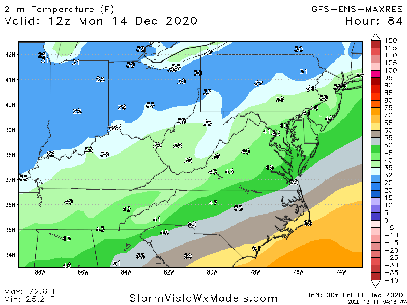
MON DEC 14 looks like a cold rain to me... the 850 mb is cold enough but 925 and surface temps are way too warm
even in the mountains
-
1
-
1
-
1
-


worst long term prediction ever ?
in Climate Change
Posted
The video from 2011 ---watch it 2x and note all the predictions that joe blowhole BUSTardi got wrong.
https://youtu.be/3mzUjn2Z-2E