

wegoweather
-
Posts
127 -
Joined
-
Last visited
Content Type
Profiles
Blogs
Forums
American Weather
Media Demo
Store
Gallery
Posts posted by wegoweather
-
-
3 hours ago, Baum said:
it's the one that will bomb at the end of the month and tank /spike all the relevant endices for winter weather in March...killing an early spring and severe season.

I don't think it's going to kill an early spring based on the fact this has been a muted winter overall, but I hope it does diminish severe season.
-
 1
1
-
-
16 minutes ago, A-L-E-K said:
the wagons west selections on youtube just doesn't have as many bangers as the rainers
-
1
-
-
19 minutes ago, A-L-E-K said:
gfs all about the consistency

Eh, what's 400 miles when dealing with the northern extent of precipitation? lol
-
 1
1
-
-
.gif.d7ecaf0e423853d690d583d54e2d33e0.gif)
-
3
-
 2
2
-
10
-
-
8 minutes ago, A-L-E-K said:
the real question, will i see flakes before it gets dark
Even the HRRR is moving up and down.
-
3
-
-
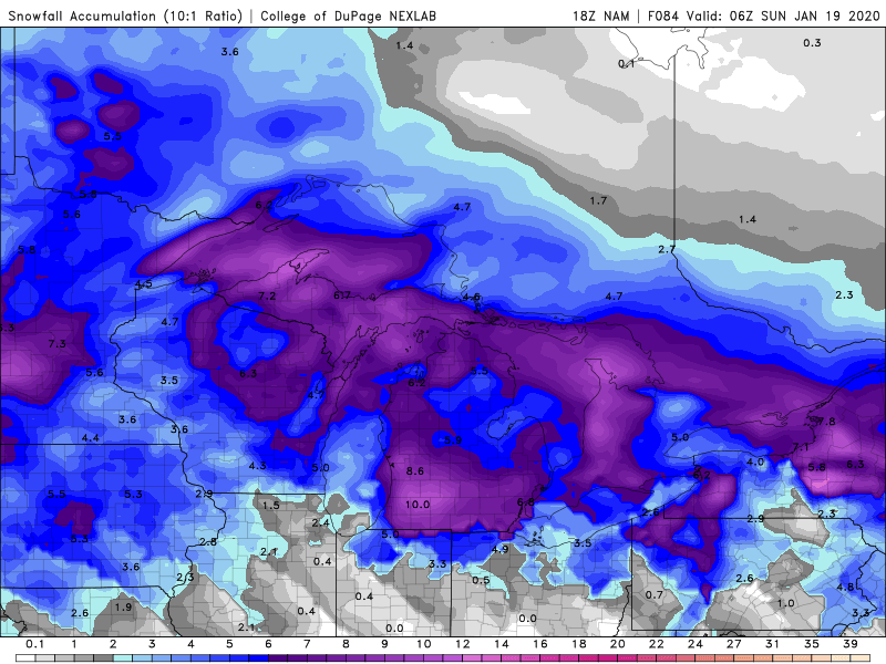
Snow plume mean up a little bit at ORD. QPF and rain up slightly too.
-
34 minutes ago, A-L-E-K said:
If you're not making a final call 100 hrs out, what's the point
Gotta draw a snow map too to really go all out.
-
2
-
-
18z NAM came in favorable for DTX and GRR. Hot mess for LOT.
-
2
-
-
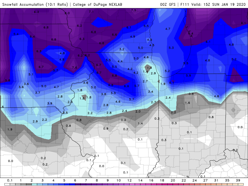
Oz GFS with an ORD donut hole.
-
1
-
-
4 minutes ago, A-L-E-K said:
absolutely nailed the last storm 4 days out, my call is gonna be $$$ again
www.betweather.com
-
1 minute ago, Thundersnow12 said:
Rainer right, Alek?
Lakeshore will be flooded, so no accumulations.
-
1
-
-
4 minutes ago, ILSNOW said:
Thinking Chicago NWS should replace Winter storm warning with an advisory and drop the areas under a watch.
Some watch areas just dropped to Advisory.
edit:
sniped
-
1 minute ago, Sciascia said:
Probably obvious, but just passing along the note that the WSW for the more NW counties (Winnebago, Boone (mby), DeKalb, McHenry, Ogle, Lee) is different than the one for Cook, in terms of snow/ice amounts.
Correct.
Multiple Watches issued with varying frozen/snow accum possibilities.
.
-
1
-
-
Winter Storm Watch on top of a Flood Watch for parts of LOT.
QuoteWinter Storm Watch
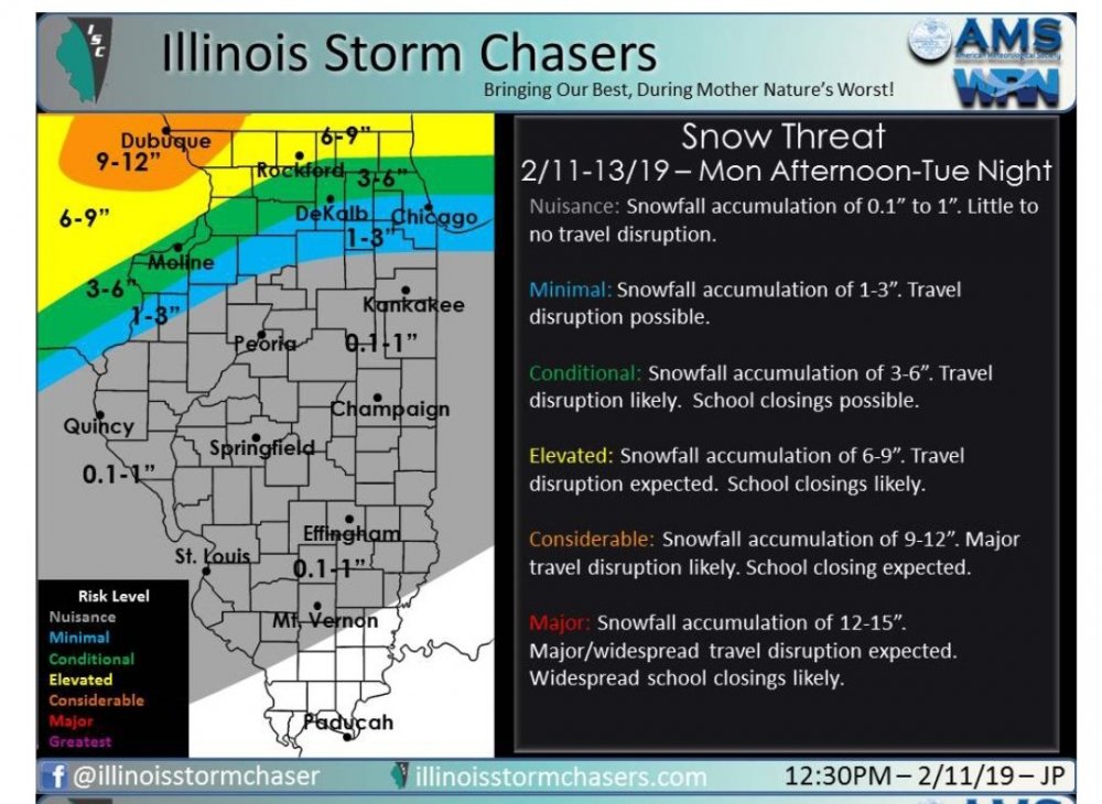
URGENT - WINTER WEATHER MESSAGE
National Weather Service Chicago IL
136 PM CST Thu Jan 9 2020

...Significant Snow and Ice Accumulations Possible late Friday
Night Through Saturday Night...


ILZ006-012-013-019-020-100345-
/O.NEW.KLOT.WS.A.0001.200111T0600Z-200112T0900Z/
Lake IL-Kane-DuPage-La Salle-Kendall-
Including the cities of Waukegan, Buffalo Grove, North Chicago,
Highland Park, Mundelein, Gurnee, Round Lake Beach, Aurora,
Elgin, Naperville, Wheaton, Downers Grove, Elmhurst, Lombard,
Carol Stream, Addison, Ottawa, Streator, Peru, La Salle, Mendota,
Marseilles, Oswego, Boulder Hill, Yorkville, and Plano
136 PM CST Thu Jan 9 2020

...WINTER STORM WATCH IN EFFECT FROM LATE FRIDAY NIGHT THROUGH
LATE SATURDAY NIGHT...

* WHAT...A mix of freezing rain and sleet likely late Friday night
  and Saturday, possibly changing to a period of snow Saturday
  evening. Total ice and sleet accumulations in excess of a
  quarter inch are possible late Friday night into Saturday. Total
  snow accumulations in excess of 3 inches are also possible
  Saturday evening. Winds could gust as high as 40 mph Friday
  night and Saturday.

* WHERE...Lake IL, Kane, DuPage, La Salle and Kendall Counties.

* WHEN...From late Friday night through late Saturday night.

* IMPACTS...Power outages and tree damage are possible due to the
  ice and windy conditions. Travel could be significantly impacted
  across the area Friday night through Saturday evening.

PRECAUTIONARY/PREPAREDNESS ACTIONS...

Monitor the latest forecasts for updates on this situation.

&&

$$
-
4
-
-
9 minutes ago, Chicago Storm said:
Epic ice/snowstorm.
Axis of 12”+ snow, and 1-2”+ ice.
And it’s still going at 84hr, end of run.
.Plus 3"+ rain all within 150 miles.
-
14 minutes ago, Chicago Storm said:
Not too far off, and in line with guidance at that time.
How about posting the evening update too.
I thought you didn't make one?
At 8:15 pm it really wasn't a forecast anymore.
-
3
-
-
5 hours ago, Chicago Storm said:
You might have had a point, if I had actually made one.
-
3
-
-
3 minutes ago, Chicago Storm said:
18z GFS is going north too.
Slightly faster as a result too.
-
1 hour ago, StormChaser4Life said:
I totally agree. Find it pretty unlikely that this would have rain all the way into northern IL. Our last system came in from the SW and was able to pull a big slug of warm air north. However this system is diving SE from the north so it really won't be able to pull as much warm air north given its distance from the Gulf
Untrained opinion here, but there are 850 temps nearing +10C in Calgary as this starts diving down. Models have it bringing it's own warm air with it.
-
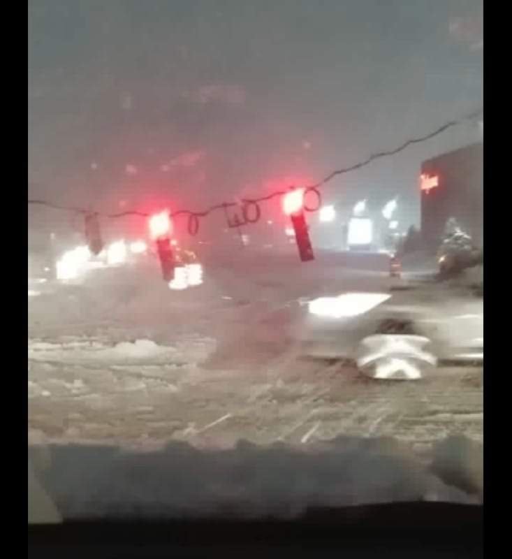
Route 59 in Bartlett @ Stearns closed due to stop lights down.
Photo from Facebook.

-
1
-
-
Numerous reports of lines down and transformer fires out this way. Fire engines are out driving around checking reports and verifying for ComEd.
-
Ripping here. Ground covered in minutes. Huge flake size.
-
1
-
-
Mixed bag just east of KDPA. Some larger flakes mixing in so hopefully a full flip is near.
-
LOT forecasts updated as well. 5-11 IMBY by KDPA.
-
1
-
Winter 2019-20 Medium/Long Range Discussion
in Lakes/Ohio Valley
Posted
True. In relation to the overall winter it may not be much better, but in relation to typical March.....
As someone who runs a spring youth sports organization and is hoping for outside field availability.....