

wegoweather
-
Posts
127 -
Joined
-
Last visited
Content Type
Profiles
Blogs
Forums
American Weather
Media Demo
Store
Gallery
Posts posted by wegoweather
-
-
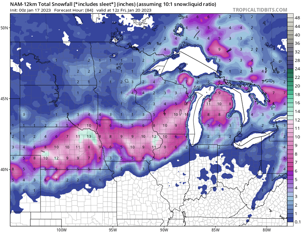
20" Big Dog plume for ORD

-
 2
2
-
-
Pingers at DPA.
-
14 minutes ago, Cary67 said:
Long range NAM looks too far SE
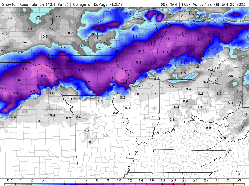
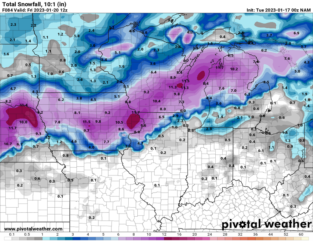
Looks more like an issue on how Tropical is handling the data. Pivotal and COD are showing a different outcome on the SE extent of the snow.
-
 1
1
-
 1
1
-
-
Snow totals decrease and heaviest totals move north and east.
-
1
-
-
16 minutes ago, DaveNay said:
Another 50 miles west and ORD is gonna get 2" of rain.
Already has .50" to .75" in this run.
-
Parachutes dusted the ground at KDPA in a few minutes before transitioning to a mix.
-
-
1 hour ago, Thundersnow12 said:
Yeah hopefully that bozo who works for ISC can finally up amounts on their snowfall map
MSPaint is hard.
-
Battle for which is messier, the storm or creating 3 threads for the storm.
-
2
-
1
-
-
6 minutes ago, Thundersnow12 said:
That looks like close to 36” in east central IL to NW IN, north of LAF
Heck, how about 24"+ on straight 10:1.
-
1
-
-
5 minutes ago, mimillman said:
LOT just issued watches
Message: NOAA-NWS-ALERTS-IL1261CB32631C.WinterStormWatch.1263DC011240IL.LOTWSWLOT.103c7bc075e65d55d974b3b26277e43b from [email protected] Sent: 14:47 CST on 12-30-2021 Effective: 09:00 CST on 01-01-2021 Expires: 06:00 CST on 01-02-2022 Event: Winter Storm Watch Alert: ...WINTER STORM WATCH IN EFFECT FROM SATURDAY MORNING THROUGH LATE SATURDAY NIGHT... * WHAT...Steady, blowing snow and dangerous travel possible. Total snow accumulations greater than 6 inches and northeasterly wind gusts in excess of 40 mph are possible. * WHERE...Lake IL, DuPage, Northern Cook, Central Cook and Southern Cook Counties. * WHEN...From Saturday morning through late Saturday night. * IMPACTS...Travel could be very difficult. Widespread blowing snow could significantly reduce visibility, especially along the Lake Michigan shoreline. * ADDITIONAL DETAILS...The steadiest snow rates appear most likely between noon Saturday and midnight Sunday.
Instructions: Monitor the latest forecasts for updates on this situation. Target Area: Central Cook
DuPage
Lake
Northern Cook
Southern CookEvent: Winter Storm Watch Alert: ...WINTER STORM WATCH IN EFFECT FROM SATURDAY MORNING THROUGH SATURDAY EVENING... * WHAT...Steady, blowing snow and dangerous travel possible. Total snow accumulations greater than 6 inches and northeasterly wind gusts in excess of 35 mph are possible. * WHERE...Portions of north central and northeast Illinois. * WHEN...From Saturday morning through Saturday evening. * IMPACTS...Travel could be very difficult. Widespread blowing snow could significantly reduce visibility, especially in open areas. * ADDITIONAL DETAILS...The steadiest snow rates appear most likely between noon Saturday and midnight Sunday.
Instructions: Monitor the latest forecasts for updates on this situation. Target Area: Boone
De Kalb
Eastern Will
Grundy
Kane
Kendall
La Salle
Lee
McHenry
Northern Will
Ogle
Southern Will
Winnebago -
8 hours ago, Hoosier said:
Take a trip down memory lane with some old TWC style graphics. Just enter your location.
That's great. I got a snow removal job back in high school off the scroll on the bottom.
-
8 minutes ago, janetjanet998 said:
can't ever quite make it to ORD though with the pushes
0 for 3 now
the storm total difference between ORD and MDW will be LOL X 10
due to the above plus * snow measurements early on at ORD
Band never making it to ORD means * is likely not an *, or much less than some want to think.
-
1 hour ago, StormChaser4Life said:
Gfs took a step in the right direction.
-
1
-
4
-
-
Just east of KDPA
-
Very light mix of pingers and the occassional flake at KDPA.
-
12 minutes ago, Chicago WX said:
Trending in the wrong direction
 . Looking the p-type plots, lots of rainers. 21z will be different. They usually follow whatever the preceding NAM does. And it was better for us.
Regardless, 6” is the goal. Hopefully we can get there!
Some 15z SREF members are definitely bringing mix and straight rain further north and west than the 18z NAM.
-
12 minutes ago, ILSNOW said:
and it is being weighed down by 5 members at 2 inches. Also it has 11 members between 8.5 and 13.5 inches.
10 members over 10 inches.
Looking at PType, my guess is some of the duds are effected by mixing/temp profiles.
Edit: about half the duds are ptype (temp), half are total qpf (storm miss).
-
1
-
-
Plumes trending up to 7.5 total at ORD.
Less than an inch from the first wave.
-
12 minutes ago, A-L-E-K said:
Is it still gonna snow?
Somewhere it is going to snow. Accumulations between a turd duster and a foot.
-
9 hours ago, Malacka11 said:
Before the 25th of December
-
1
-
1
-
-
2 hours ago, Baum said:
so rainer for Alek....snow for everyone else. Winter is on.
.gif.d7ecaf0e423853d690d583d54e2d33e0.gif)
-
3
-
-
12z GEFS have tightened up on storm track. North of Ukie, south of op GFS.
-
1
-
-
Just now, Baum said:
Coldest I've ever been was spring baseball and spring track as a spectator.
We are a lacrosse program. We've played in snow, sleet, 34 degree rain, 90 degree sun, and everything in between. We also do summer lacrosse and have had 100+ degree days.
I have everything from snow shovels and boots to a portable misting system at the ready.
-
 1
1
-


March 3-4 Potential Winter Storm
in Lakes/Ohio Valley
Posted
HRRR ptype and highest totals look very dependent on precip rates/evaporative cooling overcoming low ratios and surface temps.