

wegoweather
-
Posts
127 -
Joined
-
Last visited
Content Type
Profiles
Blogs
Forums
American Weather
Media Demo
Store
Gallery
Posts posted by wegoweather
-
-
Haven't gone back to look but I seem to remember some of the CAMs generally modeling where we sit currently (at least in the LOT CWA).
-
 1
1
-
-
13 minutes ago, Chicago Storm said:
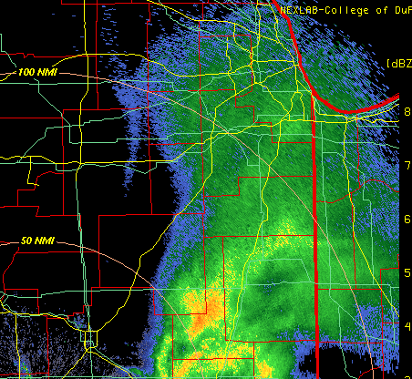
Some sort of gravity wave type of feature has moved across the metro/NE Illinois, with a brief, but sharp increase in winds.
ORD gusted to 55MPH.
.Looks like you can see it from ILX Radar.
-
5
-
-
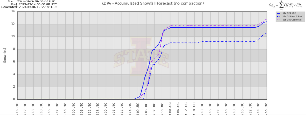
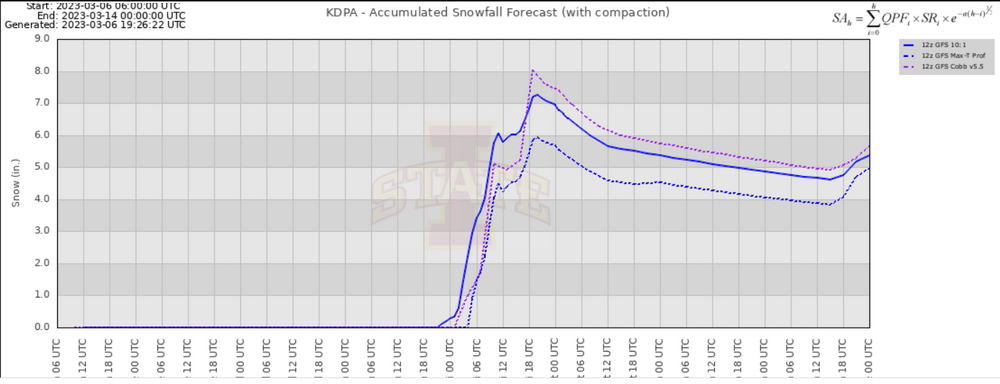
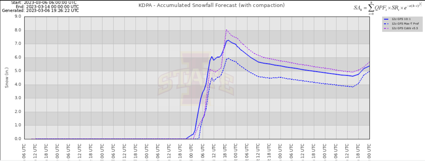
With the amount of snow and the low ratios, compaction is going to really factor in. Would be interesting if someone had the time to run two snowboards and do an aggregate hourly and storm total measurements.
-
Small error in the LOT WSW text in regards to the counties.
QuoteWinter Storm Warning
URGENT - WINTER WEATHER MESSAGE
National Weather Service Chicago IL
222 PM CST Thu Jan 11 2024

ILZ005-012-013-120430-
/O.UPG.KLOT.WS.A.0002.240112T1200Z-240113T1800Z/
/O.NEW.KLOT.WS.W.0002.240112T0900Z-240113T1800Z/
McHenry-Kane-DuPage-
Including the cities of Crystal Lake, Algonquin, McHenry,
Woodstock, Aurora, Elgin, Naperville, Wheaton, Downers Grove,
Lombard, and Carol Stream
222 PM CST Thu Jan 11 2024

...WINTER STORM WARNING IN EFFECT FROM 3 AM FRIDAY TO NOON CST
SATURDAY...

* WHAT...Heavy snow, strong westerly winds, and dangerous travel
  conditions expected. Total snow accumulations in excess of 8
  inches and wind gusts up to 45 mph expected.

* WHERE...Winnebago, Boone, Ogle, Lee and De Kalb Counties.

* WHEN...From 3 AM Friday to noon CST Saturday.

* IMPACTS...Travel could be very difficult to impossible. Areas
  of blowing snow could significantly reduce visibility. The
  hazardous conditions could impact the morning or evening
  commute.

* ADDITIONAL DETAILS...Snow may mix with rain up to the Interstate
  88 corridor early Friday afternoon. Snow rates may exceed 1 inch
  per hour at times. Wind gusts up to 45 mph are expected
  primarily Friday evening and may lead to areas of blowing snow
  and very low visibility.

PRECAUTIONARY/PREPAREDNESS ACTIONS...

If you must travel, keep an extra flashlight, food, and water in
your vehicle in case of an emergency.

The latest road conditions for Illinois can be obtained on the
internet at www.gettingaroundillinois.com.
-
1
-
-
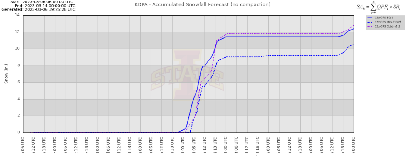
Pavement accumulations have started again at KDPA. 1.5" slush storm total so far.
-
1 minute ago, hawkeye_wx said:
Interestingly, the 00z NAMs expanded the heavier totals back to Cedar Rapids. That seems to be an outlier, though. I'm still going in expecting 6-8", with anything more being a bonus.
NAM back NW a bit and a little wamer for Chicago metro.
-
I wish I could get an old school Earl map to generate for this GFS run.
-
1
-
-
CMC has storm #2 take a right hand turn in Memphis and head for the Delmarva Peninsula eventually burying Baltimore to Boston.
-
2 minutes ago, Jersey Andrew said:
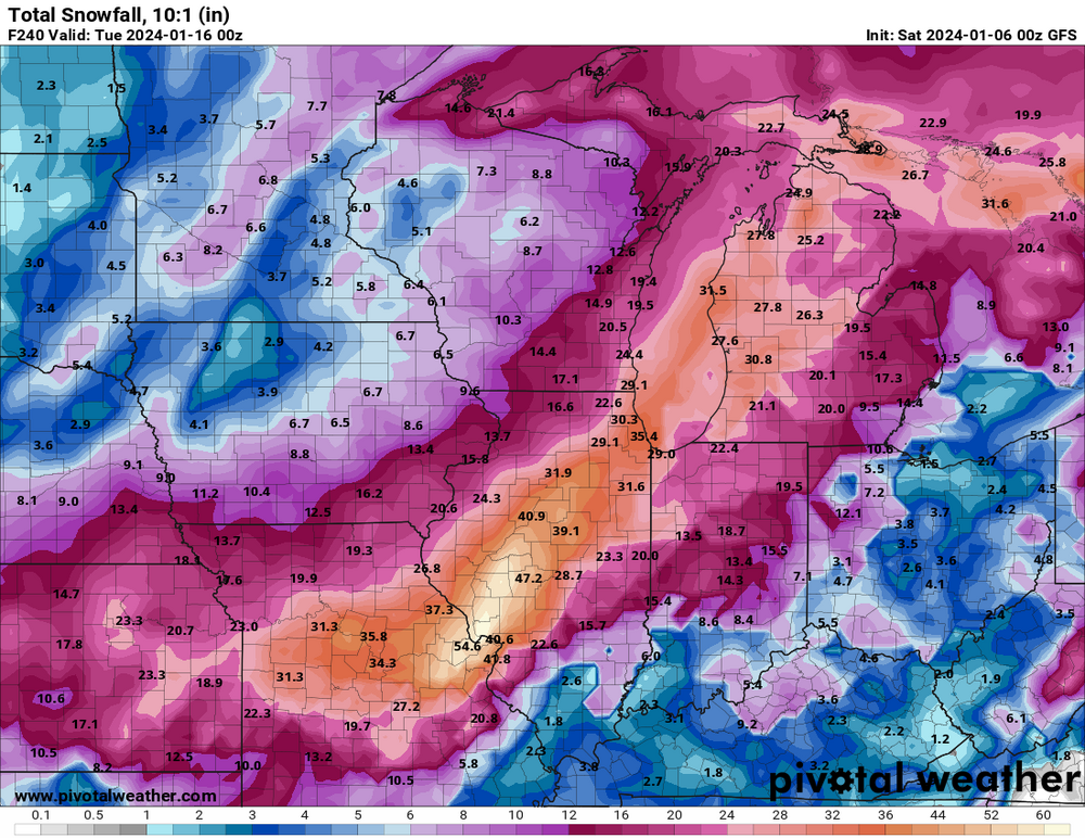
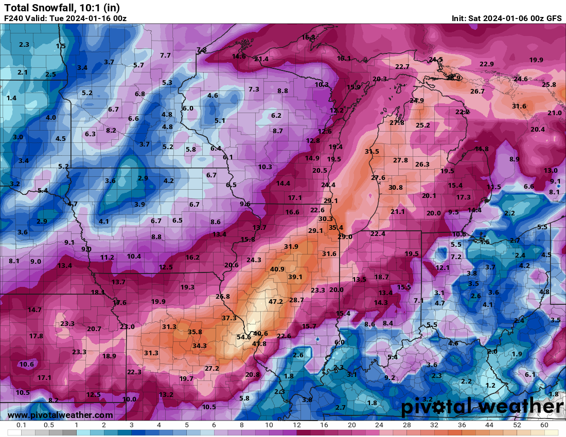
Can anyone post a map of the insane totals GFS is spitting out?
-
 1
1
-
-
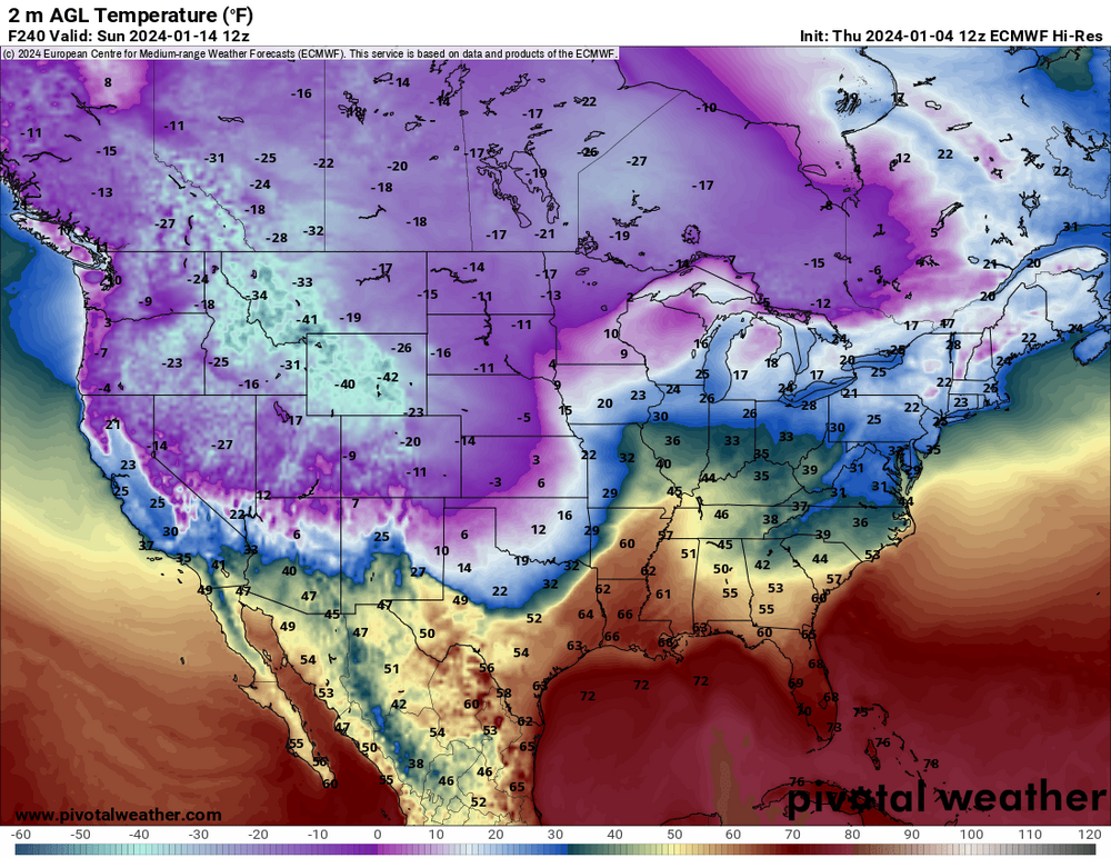
And then take a look at temps on the back end of the storm. So far showing 3 days of widespread single digit to below zero temps.
-
12 minutes ago, Chicago916 said:
Since when did GFS 360hr fantasy blizzards show up at half lead time? Lmao
Not even to 240hrs and there areas of 60+ inches north of STL in Illinois.
-
ummm....
-
3
-
-
1 hour ago, Harry Perry said:
We are still SO far out - no one should have any expectations yet.
It is nice to finally have something to watch though, and to have weenie maps is pure lust.
That's just it, most here should have correct expectations, and due to the season so far the chance for something to track and discuss is what people here want.
Many of the NWS offices have already mentioned it in AFDs and created graphics and posted on social media about the potential. The WPC has regular graphics that go out far enough for the potential. Social media has discussion by pro mets all over the place about the potential.
But here we have gatekeeping forum theatrics.
-
2
-
-
24 minutes ago, Frog Town said:
This weekend's Nor'easter did trend weaker and SE. Seems to be following last year's trends.
I've seen some interesting theories (climate change induced) on this trend on the NE forums, but it definitely appears to be a trend.
-
 1
1
-
-
180HR weenie winners from north to south....
Euro - Kansas City to Milwaukee via Quad Cities.
GFS - Columbia, Mo to Gary via Bloomington, IL
CMC - St. Louis to Detroit via Fort Wayne
-
3
-
-
16 minutes ago, andyhb said:
Low occludes too early on the 18z GFS.
Will be interesting to see the differences in the 18z deterministic vs ensemble mean.
12z GFS looked like it was one of the furthest outliers from its ensemble mean both in terms of low placement and strength. The Euro was within a higher confidence of its ensemble mean, and both the GEFS and EPS means were close in placement and strength..
-
2
-
-
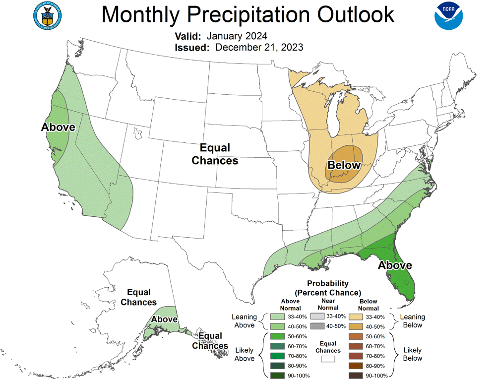
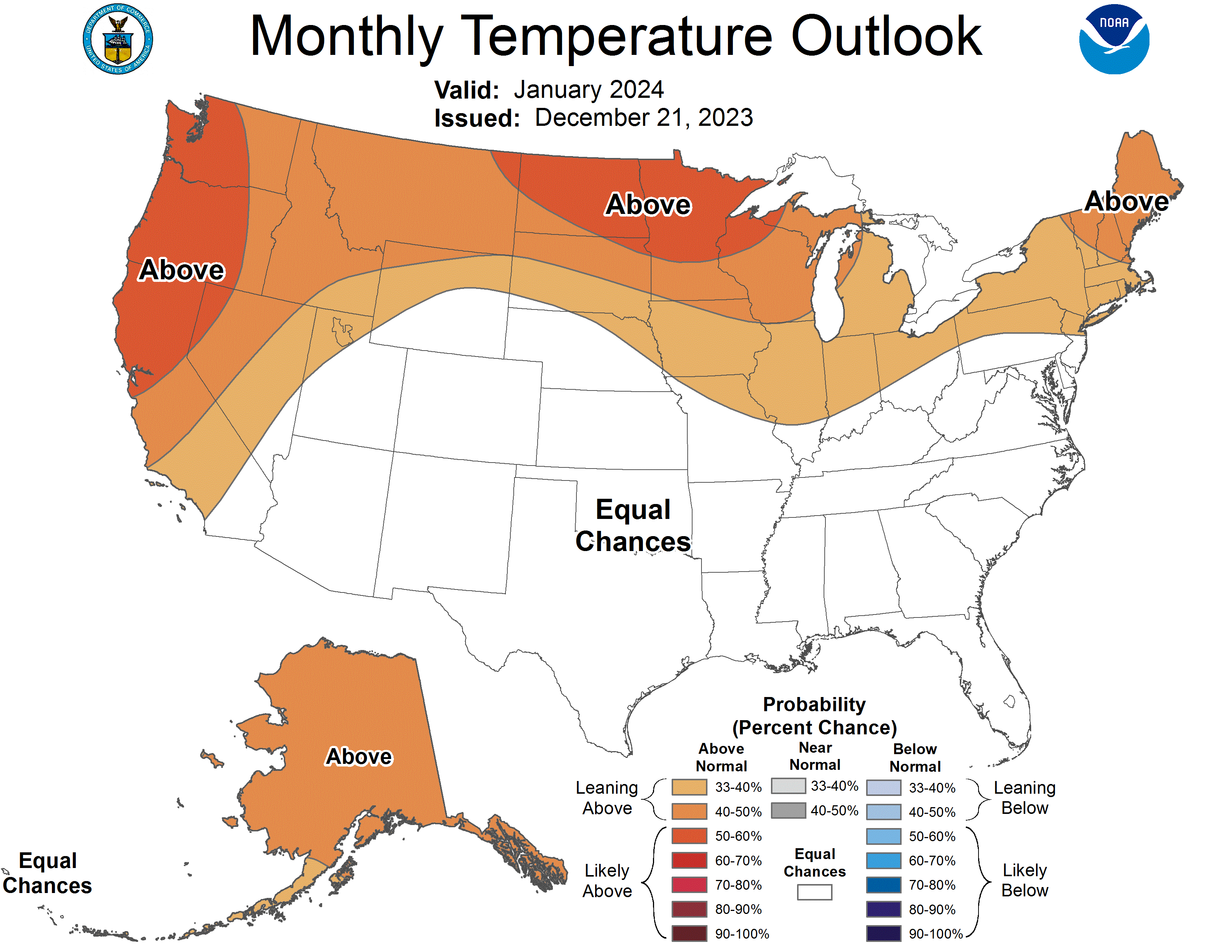
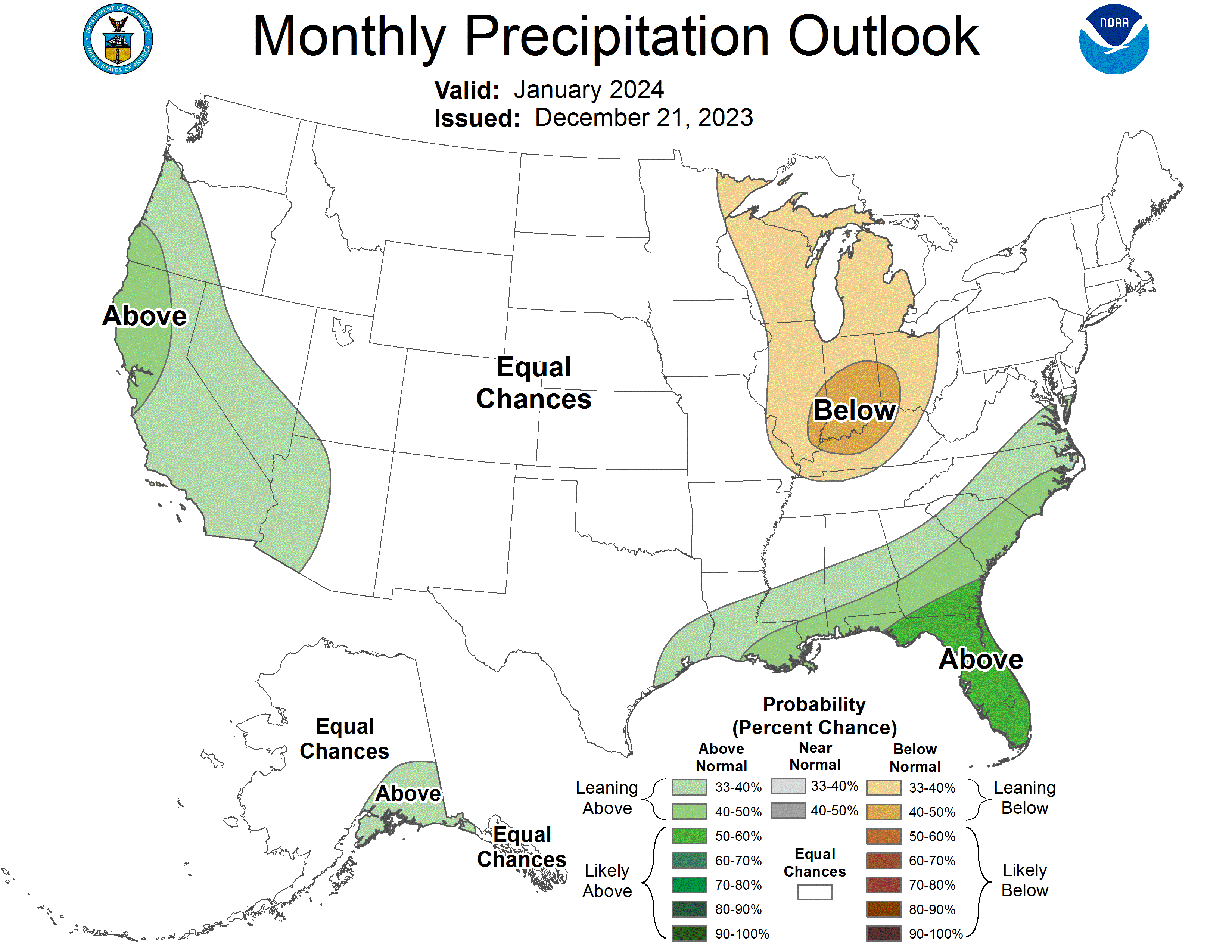
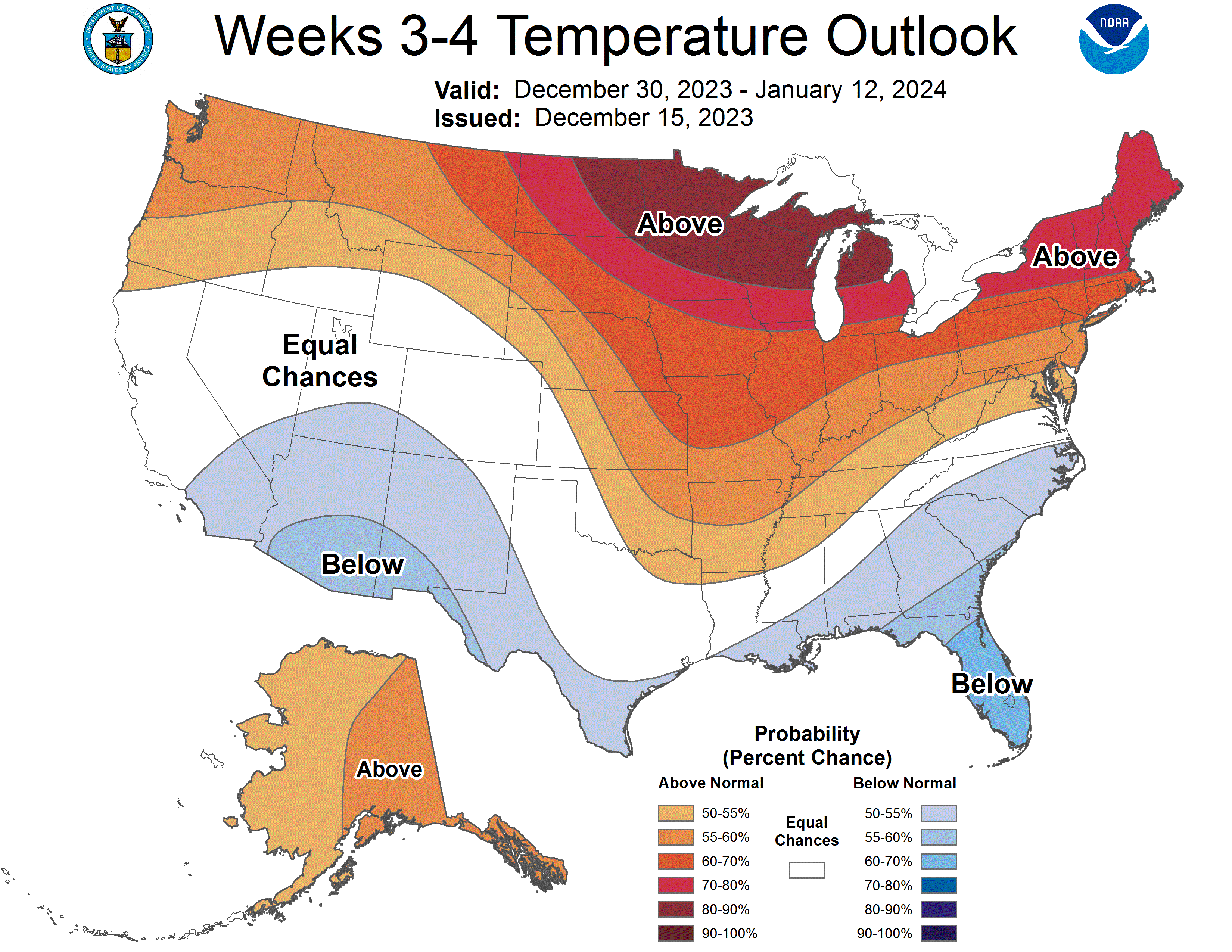
WAD. Updated 3 month outlooks are warmer and drier.

-
 1
1
-
 3
3
-
-
1 hour ago, DocATL said:
No guarantees that a SSWE will occur and furthermore lead to wide spread cold in NA. The MJO isn’t great early January and with our luck could be low amplitude.
-
3 hours ago, Stevo6899 said:
I'm all for severe weather out in open fields in Iowa, but I'll never understand why people want severe weather in their backyards and homes.
Anyone who "wants" severe weather makes no sense, but I can respect those who want it in their own backyards as opposed to somewhere else.
-
4
-
-
38 minutes ago, Cary67 said:
Do storm chasers pay exorbitant auto insurance rates?
If insurance finds out how it happened, they may not cover it at all.
A chaser that was purposely driving into hail was laughing about driving a rental car on their stream. Good chance they will have to pay the damage completely out of pocket if it's discovered what they were doing.
-
1
-
-
Non-event at KDPA.
-
Virga-fest at KDPA.
-
1 hour ago, hardypalmguy said:
Are you serious right now? The NWS did a wishy washy flip flopping in the last 12 hours. General public went from "OMG winter storm watch" to "ok no big deal just a WWA" to now "it's a warning now?" and the event hasn't even begun. Too much flip flopping. General public is now tuned out. They are already laughing about it on Facebook.
Response on NWS MKE Facebook post upgrading to a warning. I'm missing the laughing part.
-
1
-
1
-
-
Pick the algorithm.

Jan 11-13th Blizzard
in Lakes/Ohio Valley
Posted
Flipped back to snow at KDPA. We'll see what we get out of the last couple of hours.