

Ja643y
-
Posts
95 -
Joined
-
Last visited
Content Type
Profiles
Blogs
Forums
American Weather
Media Demo
Store
Gallery
Posts posted by Ja643y
-
-
2 minutes ago, Met1985 said:
NAM showing some mixing towards the later part of the run but im very suspect of that also.
Shows almost 3/4 inch of ice for a lotnof the Blue Ridge.
-
7 minutes ago, Maggie Ace said:
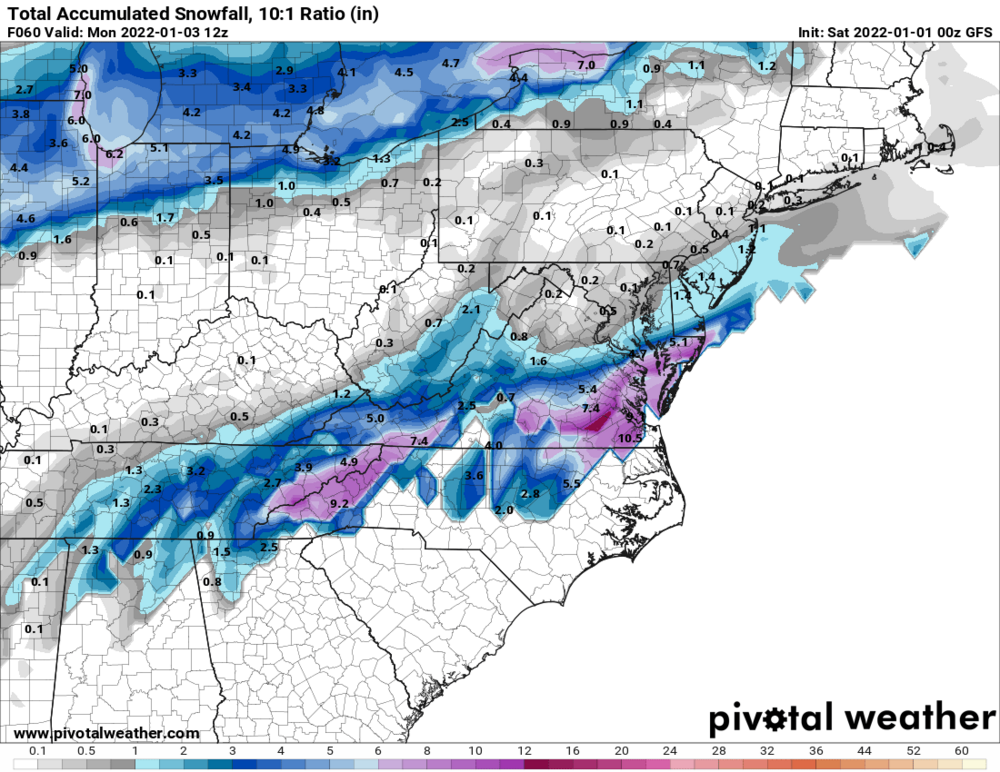
00Z GFS
.thumb.png.af0bd75ef4389f8fb8129a18f1e824fe.png)
Check please. I think I'll wait until tomorrow nights 0Z runs to make the final decision to drive 10 hours to chase this one.
-
2 minutes ago, wncsnow said:
The main thread is a disaster, thank goodness for this one
Thinking about coming up again and getting the storm I wanted 2 weekends ago... reading that main thread made me almost change my mind about wanting to come. LOL... it's looking like that Mitchell/McDowell line this time around could be close to jackpot on the last several runs
-
Wish I would have gotten my porch cam set up.
-
Looks like I left a bit early. This may end up better on the Mitchell/McDowell line than the last storm
-
 1
1
-
-
3 minutes ago, BooneWX said:
My jealousy runs deep this morning. That death band from Roan to Spruce Pine looks incredible. Rake it in fellas!
Curious to see how Spruce Pine does. I'm just up the mountain near Little Switzerland and the snow is not impressive, but the wind is INCREDIBLE
-
1
-
-
I'd guess about 1/2 inch here. I think the wind has hindered as well as being in a marginal area that didn't flip until after 5a
-
1
-
-
Just flipped to fine granular flakes. Deck starting to whiten.
-
1
-
-
Just went from 41 to 35 in about 15 minutes. Hopefully changeover soon. Wind is ripping up here.
-
3
-
-
Stuck at 43 up here on the Mitchell/McDowell line. Worried the cold air isn't going to come fast enough and totals are going to be slashed from the models. Changeover was supposed to be around 4, but I don't think we see it until 5 or later.
-
Ok... I've been watching and reading. I think I'm in a good spot and excited for the kids (we'll, me too) but tempering expectations. I'll consider 4+ a win with 6+ and 3 on the ground a jackpot
-
1
-
-
I'm optimistic. Seems I'm going to be right on the border of the heaviest rain/snow line. Hopefully with the elevation, it means we'll puke a few hours! With those kind of rates, should overcome the warm ground pretty quickly too
-
2 minutes ago, wncsnow said:
Yes, it's elevation dependent. On the eastern escarpment down in Marion to Morganton, it will take forever for the cold air to make it over the mountains. They usually only do well in CAD situations.
OK. Yea, I'm basically straight up from Marion. About 2000' higher, so hopefully that will help
-
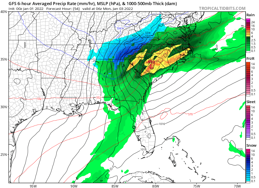
8 minutes ago, wncsnow said:
HRRR is more amped too though compared to earlier runs. This system looks like it will mean business but very fast moving
.thumb.png.6e708a0753564adb31558be55b8c7c98.png)
Noticing on most of the models I'm right on the edge between bigger totals and nothing. I'm right on the McDowell/Mitchell line. Is that a result of being on the escarpment?
-
Lock it in
-
20 minutes ago, Hvward said:
WNC about to get NAMed.
Looks like that run was better further South. Hoping it can spread the love a bit further north
-
8 minutes ago, BooneWX said:
Nearly spit my coffee out when I looked at the SREF plumes this morning. My hopes have perked up quite a bit.
Can you share?
-
Well then
-
3
-
-
Sign me up

-
1
-
-
10 minutes ago, wncsnow said:
On the next episode of "As the models turn" the NAM and HRRR have no moisture.
Big flips. I have a feeling we're going to see 6+ or flurries. Reminds me of living on LI when the forecast was for 18+ or maybe a really hard cold rain
-
I was out... and now I'm back in. Let's see what 0z runs show tonight. Then I'll start to be bought in. Wondering if I should chase up toward Beech/Sugar or if I'll be OK at my location just east of Spruce Pine
-
1
-
-
16 minutes ago, Met1985 said:
Both the euro and the GFS have slashed totals overnight for the mountains. Especially the EURO looks pretty paltry with the overnight run.
Yea, not liking the trend. Seems moisture is just going to dry up before the cold arrives.
-
3 minutes ago, Met1985 said:
You should see some snow if the synoptics works out that way. That's a decent spot for sure but as of right now we will see how this ends up.
Thanks! We're up atop a hill at 3310' with a NW facing exposure. Hoping for the best!
-
1
-
-
Hey all, up in the Spruce Pine area. Frequent here a few times a year, but normally in the warmer months. Does anyone know how this area does with snow? Not really knowledgeable, just AmericanWX learned. Trying to figure out if I've got a shot to have the kids see snow Sunday night.
Also, I'll check back to see your feedback on tonight's line. Could be interesting and I figure I'll get it about 30 minutes or so after some of the people posting tonight.
-
1
-
.png.4262cbac01ea3a6c7062fa506002b1d6.png)
.png.63b7cd29e7e63efb7f8ff254afe3081d.png)
2021-2022 Fall/Winter Mountains Thread
in Southeastern States
Posted
Just locked in the trip, driving up the 10 hours to the cabin tomorrow afternoon. I have never seen so much consistency for a single location - the last 6 GFS and last 3 or 4 Euro all printing 14+. I'll take 1/2 of that an no power outages and be super happy!