

Ja643y
-
Posts
95 -
Joined
-
Last visited
Content Type
Profiles
Blogs
Forums
American Weather
Media Demo
Store
Gallery
Posts posted by Ja643y
-
-
Just checked the camera for our place just above the BlueRidge off 226… snow finally starting come down a bit and stick on elevated parts of the deck.
-
 1
1
-
-
1 hour ago, strongwxnc said:
Found in NWS chat. .25 FR in Little Switzerland
 fff
fff
We left yesterday, but the outdoor cam I have shows more ice this morning than we had with the Saturday storm. All melted off now, but looked to be every bit of .25” this morning
-
Just a very basic temp gauge that has been here for years, not sure how well calibrated… but showed 20 for morning low, 37 for high. Currently 30.
-
1
-
-
12 minutes ago, wncsnow said:
We actually got down to 27.8 and it clouded up more and its 29 again. It was supposed to be 34 right now.
Latest HRRR has a lot more snow on the escarpment than previous runs and it's been going up each run
.thumb.png.464297e712dcf843614311da400ce841.png)
I’m right up 226 from Marion before you get to Spruce Pine. Thoughts? Hoping to keep power tonight, but wouldn’t mind the kids waking up to an inch or two of snow.
-
2
-
-
Yea, I'm just up 226 from Marion... It has not let up for nearly 2 hours. I'm from Florida, so know some good rainfall rates, and although I don't have a gauge here, would be we've picked up 2.5 to 3 inches just since 8a.
-
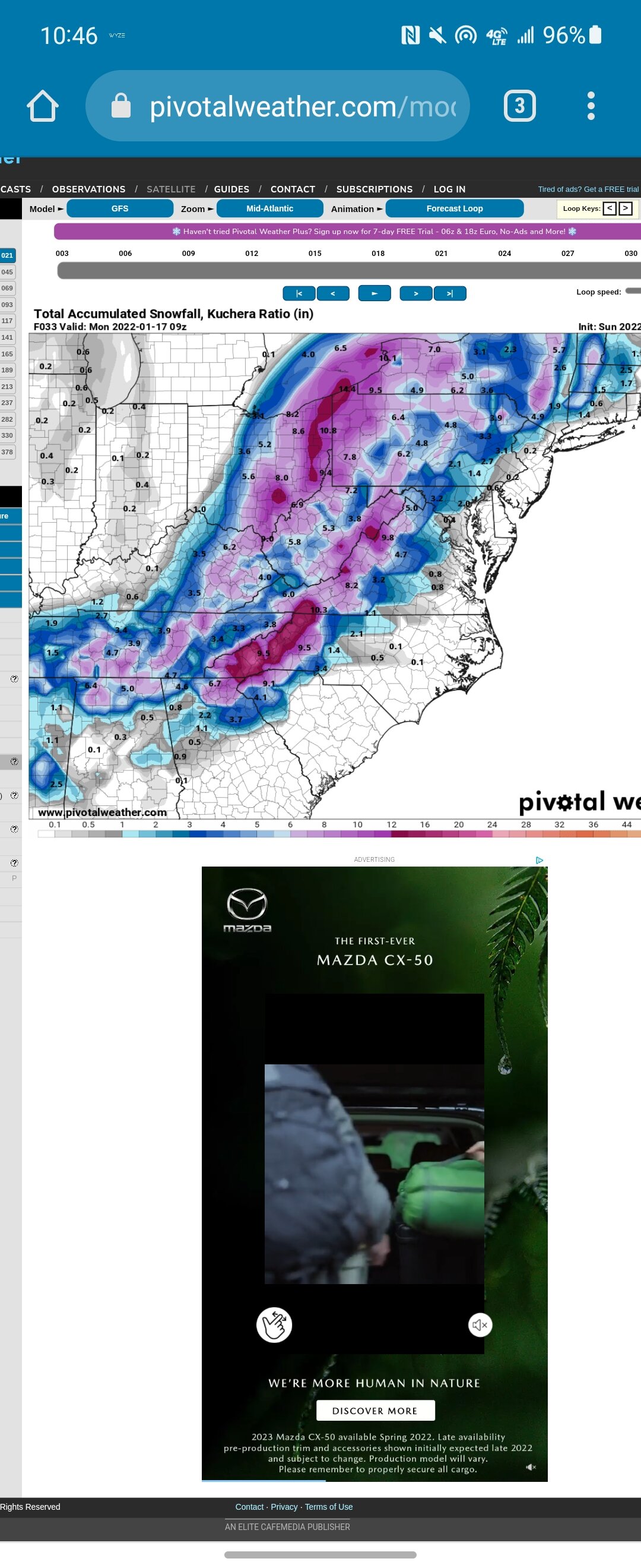
0z GFS with maybe the best output all season. Long ways off, but last 8 or so runs have held serve for some type of event.
-
1
-
-
Don’t look now, but there’s a storm 8 days out on the GFS. I’m headed up with the kids next week. It looks like it may be colder than when I was there in early January!
-
2
-
-
I’ve got a place I can go to right on the McDowell/Mitchell line just under 3,300 feet. The maps show a pretty steep drop off with almost nothing. Is there shadowing that happens or does all the moisture get rung out pretty quick NE to SW as it crosses the boarder. I’ve only been there for one storm (last year - 10”+) but never for a Flow event. Any thoughts?
-
1
-
-
Wondering if anyone has looked at Next Friday and think there’s a chance for that to trend better for the region. GFS had an interesting solution at 6z that I imagine wouldn’t be too far fetched to trend for some snow for the Mountains - but then again, I know very little and only spend a month or two a year up here, so don’t know all the nuances.
-
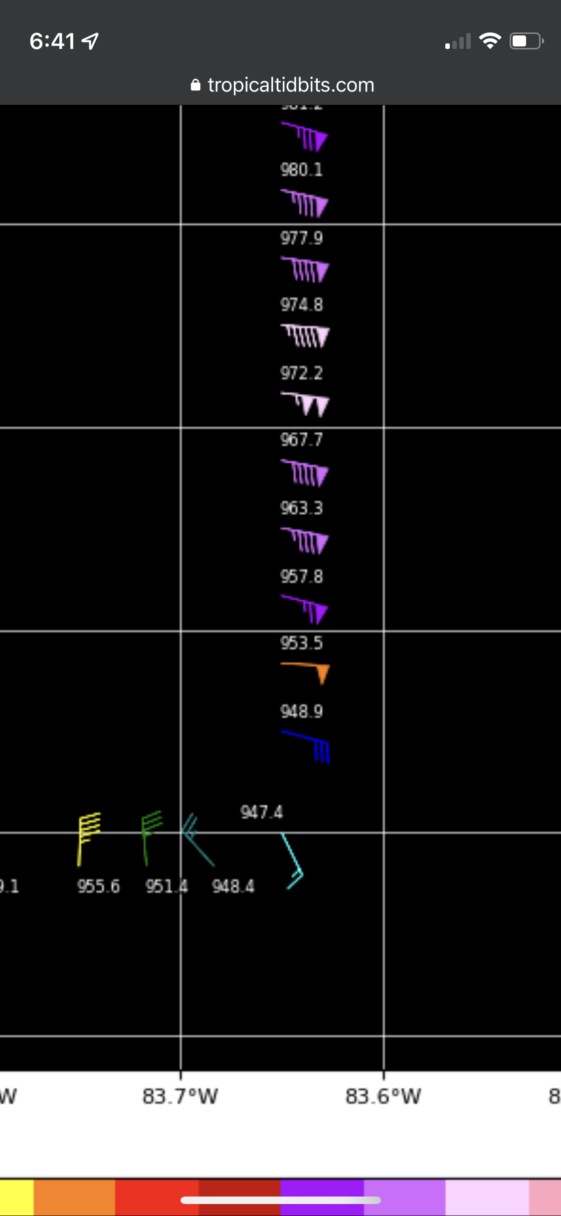
Hurricane Hunter showing reading of 947.4 over land.. is this extrapolated from Wind speed? They obviously aren’t dropping dropsondes over land.

-
https://www.weather.gov.ky/radar
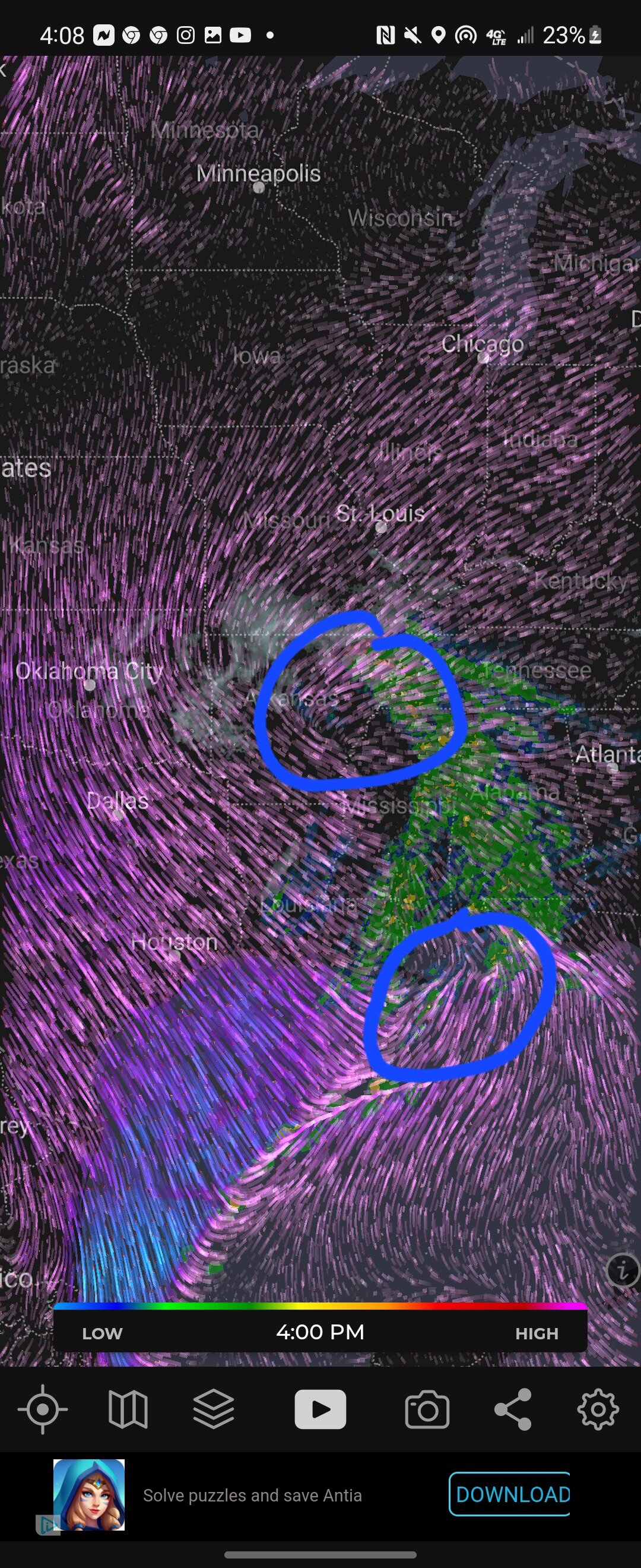
looking at Cayman Radar, seems like the eye may be tightening, but also causing it to move due N or maybe even a smidge E of N… anyone else see this? -
Not familiar with the area yet, how does the Spruce Pine area in Mitchell County set up for Flow Snow?
-
Just turned to a HEAVY sleet for the first time.
-
Fattest flakes of the storm right now
-
3
-
-
Solid 5.5" everywhere here and coming down hard! I think we get 10" by the time it's all said and done
-
 1
1
-
-
⁰22 degrees and coming down at a good clip. I'd say between 4 and 5 inches here near Little Switzerland.
-
Coming down pretty good. Eyeballing 1.5” on the railing!
-
Remarkably consistent. 12+ for probably 10 straight runs. If it verifies, I'll be thrilled and very impressed with the lead time at which this was accurate

-
First flakes - really fine, but quickly whitened up the deck railing. Near Little Switzerland @ around 3300'
-
4
-
-
2 minutes ago, franklin NCwx said:
Lol... big time in haywood County. I'll have a big pot of chili tomorrow
Our Chili is cooking now to be ready for tomorrow! Sausage and Peppers tonight!
-
1
-
-
No real idea, looking for some input. Is there anything to the low level circulation of the winds down near Louisiana coast? Could that be where the LP tries to "jump south" over the next few hours as some of the models show?

-
1 minute ago, Blue_Ridge_Escarpment said:
I’m 2 miles from the Chalet in little Switzerland, hopefully these totals pan out.
I'm about the same. I'll take 50% and call it a huge win
-
1
-
-
2 minutes ago, Blue_Ridge_Escarpment said:
Per 3k NAM, 2 feet at little Switzerland and a dusting from weaverville to mars hill, wow!
That's a jackpot IMBY. Lol
-
2
-
-
2 minutes ago, wncsnow said:
Scrumptious
(21).thumb.png.e87b60aa2efa3622749e24af6e08daaf.png)
21" IMBY... that's upped from the consistent 15-18 the last 6 runs have shown. Incredible even if half that verifies.
-
1
-
.png.0d8545ee3ef2ba9faeaa75b1ac61adaf.png)
(21).png.b7626ae2232fa0f45e19ad782ee0634e.png)
2023-2024 Fall/Winter Mountain Thread
in Southeastern States
Posted
Just like that back to mostly rain. Looks very rate dependent