stormtracker
-
Posts
64,389 -
Joined
-
Last visited
Content Type
Profiles
Blogs
Forums
American Weather
Media Demo
Store
Gallery
Everything posted by stormtracker
-

Feb 22nd/23rd "There's no way..." Storm Thread
stormtracker replied to Maestrobjwa's topic in Mid Atlantic
I don't think it ever has tbh -
Feb 22nd/23rd "There's no way..." Storm Thread
stormtracker replied to Maestrobjwa's topic in Mid Atlantic
Well, the mood killer will be along in an hour to bring this place into the sunken. But what if...if showed what the GFS is showing. This server would melt down. -
Feb 22nd/23rd "There's no way..." Storm Thread
stormtracker replied to Maestrobjwa's topic in Mid Atlantic
Ok, the CMC and UKmet lends credence to what we all know: GFS is in la la land -
Feb 22nd/23rd "There's no way..." Storm Thread
stormtracker replied to Maestrobjwa's topic in Mid Atlantic
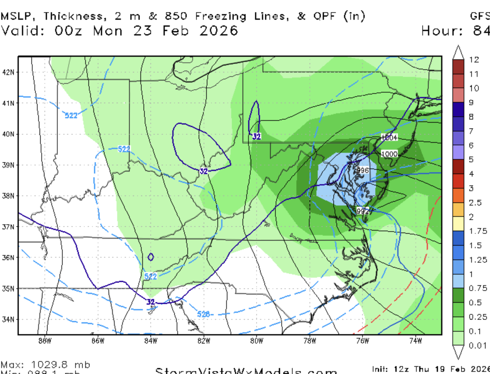
If you know what to expect, it won't be. The GFS is literally on its own. I hope nobody here is falling for this. It has a historic blizzard at 84 hours and it will be wrong. That's fucking embarrasing. -
Feb 22nd/23rd "There's no way..." Storm Thread
stormtracker replied to Maestrobjwa's topic in Mid Atlantic
The unfortunate thing about all of this is...it's the GFS. It's thrilling to see, but the come down is already happening for me. NAM is shit, but that model usually goes crazy in situations like this. And it's got jack shit. -
Feb 22nd/23rd "There's no way..." Storm Thread
stormtracker replied to Maestrobjwa's topic in Mid Atlantic
Too low -
Feb 22nd/23rd "There's no way..." Storm Thread
stormtracker replied to Maestrobjwa's topic in Mid Atlantic
I'm at a loss for words...like WTF -
Feb 22nd/23rd "There's no way..." Storm Thread
stormtracker replied to Maestrobjwa's topic in Mid Atlantic
I don't know any others to describe this -
Feb 22nd/23rd "There's no way..." Storm Thread
stormtracker replied to Maestrobjwa's topic in Mid Atlantic
It's just filthy yall. -
Feb 22nd/23rd "There's no way..." Storm Thread
stormtracker replied to Maestrobjwa's topic in Mid Atlantic
This would be an all time snowfall for the forum. -
Feb 22nd/23rd "There's no way..." Storm Thread
stormtracker replied to Maestrobjwa's topic in Mid Atlantic
FUCK -
Feb 22nd/23rd "There's no way..." Storm Thread
stormtracker replied to Maestrobjwa's topic in Mid Atlantic
Jesus -
Feb 22nd/23rd "There's no way..." Storm Thread
stormtracker replied to Maestrobjwa's topic in Mid Atlantic
FOLKS -
Feb 22nd/23rd "There's no way..." Storm Thread
stormtracker replied to Maestrobjwa's topic in Mid Atlantic
GFS is a good bit wetter. It's a huge hit. Everything shifted back west with the heavier amounts so far. It Mauls us -
Feb 22nd/23rd "There's no way..." Storm Thread
stormtracker replied to Maestrobjwa's topic in Mid Atlantic
It's a pbp friend. I'm describing the model, not saying I believing it -
Feb 22nd/23rd "There's no way..." Storm Thread
stormtracker replied to Maestrobjwa's topic in Mid Atlantic
It's wetter so far -
Feb 22nd/23rd "There's no way..." Storm Thread
stormtracker replied to Maestrobjwa's topic in Mid Atlantic
Guys -
Feb 22nd/23rd "There's no way..." Storm Thread
stormtracker replied to Maestrobjwa's topic in Mid Atlantic
GFS is def more amp'd so far vs 6z at H5 -
Feb 22nd/23rd "There's no way..." Storm Thread
stormtracker replied to Maestrobjwa's topic in Mid Atlantic
Because we are data freaks. Goes hand in hand with loving weather/snow. -
Feb 22nd/23rd "There's no way..." Storm Thread
stormtracker replied to Maestrobjwa's topic in Mid Atlantic
Yeah, insomnia caught up with me finally and I was out at like 11 last night and just woke up. The GFS is still a shit ass model and I'm in no way excited by it. -
Feb 22nd/23rd "There's no way..." Storm Thread
stormtracker replied to Maestrobjwa's topic in Mid Atlantic
It's vastly improved..more precip by far than 12z, BUT STILL NOT LIKE THE GFS. I don't have snow maps, but there will be increase in snow amounts, but probably nothing earth shattering -
Feb 22nd/23rd "There's no way..." Storm Thread
stormtracker replied to Maestrobjwa's topic in Mid Atlantic
Better run. Not good as the GFS, but trending the right way. -
Feb 22nd/23rd "There's no way..." Storm Thread
stormtracker replied to Maestrobjwa's topic in Mid Atlantic
Ok, got to 69 (hehe) and the difference is more evident out front. -
Feb 22nd/23rd "There's no way..." Storm Thread
stormtracker replied to Maestrobjwa's topic in Mid Atlantic
Slighter more amp'd so far than 12z. But nothing to get excited about....so far